List of Public Service Railway lines

Last updated

The Public Service Railway operated the following streetcar lines in the U.S. state of New Jersey. Public Service assigned odd numbers to streetcar routes (as shown here) and even numbers to bus routes. [1]

Contents

Bergen Division

RouteTerminalsMajor streetsHistoryCurrent status
1 Hudson RiverEdgewater Ferry Terminal, Edgewater Paterson Broadway Terminal part of the 751 bus route (east of Hackensack)
770 bus route (west of Hackensack)
3 Fort Lee Leonia part of the 755 bus route
5 Englewood Tenafly part of the 166 bus route (north of Palisades Park)
5 Paterson-Suffern Paterson Broadway Terminal Suffern, New York roughly the 746 bus route (south of Ridgewood)
9 Coytesville Edgewater Ferry Terminal, Edgewater Coytesville History Replacement buses

Central Division

RouteTerminalsMajor streetsHistoryCurrent status
1 South Amboy New Brunswick South Amboy roughly part of the 815 bus route
3 Middlesex New Brunswick Perth Amboy 814 bus route (west of Bonhamtown)
813 bus route (east of Bonhamtown)
5 Rahway Perth Amboy Westfield
7 Carteretjunction with Newark-Trenton Fast Line Carteret part of the 62 bus route
9 Highland Park New Brunswick Piscatawaytown roughly part of the 810 bus route (east of downtown New Brunswick)
11 Elizabeth Newark Elizabeth
13 EastonNew Brunswickpart of the 811 bus route
15 New Brunswick-Trenton New Brunswick Trenton
27 Aldene Elizabeth Aldene part of the 58 bus route
27 Elmora Elizabeth Elmora part of the 58 bus route
27 Raritan New Brunswick Raritan
29 Jefferson Elizabeth
45 Perth Amboy Newark Perth Amboy part of the 62 bus route
47 New Brunswick-Newark Newark New Brunswick
49 Union Newark Bound Brook 59 bus route (east of Dunellen)
part of the 114 bus route (west of Dunellen)

Essex Division

RouteTerminalsMajor streetsHistoryCurrent status
1 Newark Newark Public Service Terminal Exchange Place part of the 1 bus route
3 BergenNewark
5 KinneyNewarkroughly part of the 34 (east of downtown Newark)
part of the 5 bus route (west of downtown Newark)
7 City Subway Broad St. (renamed "Military Park" in 2012)
Newark Penn Station
Franklin Ave. (renamed "Branch Brook Park" in 2012)
Grove St.
Morris Canal bed Newark City Subway Still exists; incorporated into Newark Light Rail
7 WeequahicNewarkroughly part of the 39 bus route
9 CliftonNewarkpart of the 99 bus route
13 BroadNewark Nutley part of the 13 bus route
15 NutleyNewark Nutley part of the 13 bus route
17 PatersonNewark Paterson part of the 13 bus route (south of Nutley)
part of the 74 bus route (north of Nutley)
19 Crosstown Orange Bloomfield roughly part of the 92 bus route
21 OrangeNewark Orange 21 bus route
23 CentralNewark Orange part of the 24 bus route
25 SpringfieldNewark Maplewood roughly part of the 34 bus route (east of downtown Newark)
25 bus route (west of downtown Newark)
27 Mount ProspectNewarkpart of the 27 bus route
29 BloomfieldNewark Bloomfield or Caldwell part of the 29 bus route (Caldwell)
part of the 72 bus route (Bloomfield)
31 South OrangeNewark Maplewood roughly part of the 25 bus route (east of downtown)
part of the 31 bus route (west of downtown Newark)
33 MarketNewarkpart of the 1 bus route
35 Kearny Hillside North Arlington part of the 59 bus route (south of downtown Newark)
roughly part of the 39 and 76 bus routes (north of downtown Newark)
37 HackensackNewarkEdgewater Ferry Terminal, Edgewater Ridge Road, Park Avenue, Hackensack Street, Court Street, Degraw Avenueroughly the 76 (south of Hackensack)
part of the 751 bus route (east of Hackensack)
39 HarrisonNewark North Arlington part of the 39 bus route
41 Montrose Orange South Orange
43 Jersey City Newark Public Service Terminal Exchange Place 43 bus route
51 Irvington Irvington part of the 13 bus route
59 Valley Road East Orange Montclair part of the 34 and 28 bus routes

Hudson Division

RouteTerminalsMajor streetsHistoryCurrent status
1 Newark Newark Public Service Terminal Exchange Place Essex Division train through Hudson County part of the 1 bus route
3 Newark Avenue Jersey City Newark Avenue
5 Pacific Avenue Jersey City
7 Jackson Hudson Place (Hoboken) Bayonne Courthouse

Jackson Ave

elevated 87 bus route (north of Bayonne)
part of 81 bus route (in Bayonne)
9 Newark Avenue Jersey City
11 Montgomery Jersey City roughly the 80 bus route
13 Greenville Jersey City Bayonne 81 bus route
15 Passaic Hudson Place (Hoboken) Paterson Broadway Terminal Transfer Station roughly part of the 85 bus route (south of Secaucus)
17 Summit Hudson Place (Hoboken) Transfer Station elevated part of 85 bus route
19 Union City Hudson Place (Hoboken) or West Shore Ferry Terminal Hudson Place (Hoboken) or West Shore Ferry Terminal Bergenline
Pershing Road
Union Hill roughly part of the 89 bus route
21 West New York Hudson Place (Hoboken)
14th Street (Hoboken)
West Shore Ferry Terminal,
Nungesser's Willow Avenue
Pershing Road
part of the 89 bus route (south of Union City)
part of the 181 bus route (north of Union City)
23 Palisade West Shore Ferry Terminal Fort Lee Pershing Road
25 Weehawken Hudson Place (Hoboken) West Shore Ferry Terminal, Weehawken Willow Avenue
Pershing Road
27 Pavonia Pavonia Terminal Transfer Station roughly the 82 bus route
29 Hudson Exchange Place Secaucus Transfer Station 82 bus route (south of Union City)
31 Grove Exchange Place Hudson Place (Hoboken)
33 Crosstown Pavonia Terminal Communipaw Junction Jersey City
33 West Hoboken Hudson Place (Hoboken) Union City
35 Bergen Exchange Place or Hudson Place Hackensack Plank Road Hackensack roughly the 83 bus route
35 Journal Square Jersey City
35 Secaucus Jersey City Secaucus Paterson Plank Road Transfer Station
37 Oakland Hudson Place (Hoboken) Jersey City Courthouse elevated rush hour service
39 Willow Hudson Place (Hoboken) 14th Street (Hoboken) Willow Avenue
57 South Kearny Jersey City Kearny
59 Federal [2] Exchange Place Kearny Montgomery Street1943–1945

Passaic Division

RouteTerminalsMajor streetsHistoryCurrent status
3 Singac Paterson Broadway Terminal Singac part of the 704 bus route
7 Governor Paterson
9 Park Avenue Paterson Broadway Terminal Patersonpart of the 744 bus route
11 TotowaPaterson Totowa roughly part of the 704 and 722 bus routes (northeast of downtown Paterson)
13 HaledonPaterson Haledon part of the 703 bus route
76 Paterson Orange Paterson station Orange station

Southern Division

RouteTerminalsMajor streetsHistoryCurrent status
5 Haddon HeightsPennsylvania-Reading Seashore Lines (Pennsylvania RR, Camden & Amboy RR) Federal St. Ferry Terminal, CamdenClementon Lake Amusement Park, ClementonHaddon Ave., Atlantic Ave.By 1935, a 1 trolley shuttle at the Clementon end, then All Service Vehicles, later part of the 50 & 53 bus routesno exact service in 2012

Related Research Articles

<span class="mw-page-title-main">Newark Light Rail</span> Light rail system

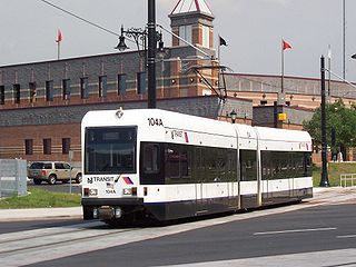
The Newark Light Rail (NLR) is a light rail system serving Newark, New Jersey and surrounding areas, owned by New Jersey Transit and operated by its bus operations division. The service consists of two segments, the original Newark City Subway (NCS), and the extension to Broad Street station. The City Subway opened on May 16, 1935, while the combined Newark Light Rail service was officially inaugurated on July 17, 2006.

<span class="mw-page-title-main">Brookville Equipment</span> Rolling stock manufacturer

Brookville Equipment Corporation, based in Brookville, Pennsylvania, United States, manufactures railroad locomotives for industrial and light capacity switching needs. The company also builds and restores streetcars. The company used to be known as Brookville Locomotive Company.

<span class="mw-page-title-main">Newark Public Service Terminal</span>

The Public Service Terminal was a three-level streetcar station in Newark, New Jersey, owned and operated by the Public Service Corporation, adjacent to the Hudson and Manhattan Railroad's Park Place station. It served as the terminus for streetcar lines from as far as Trenton. Public Service was both a transportation company and a utility, providing electric and gas service to much of northern New Jersey. The six office stories above the terminal served as company headquarters.

<span class="mw-page-title-main">Public Service Corporation</span>

The Public Service Corporation (PSC) was an energy and transportation company in New Jersey. It was formed to shore up financing and development of New Jersey's streetcar and power companies at a time when they were growing but exhausting capital. It did this by leasing their operations or buying them outright, and using the size and integration of the systems to get favorable financing for improvements.

<span class="mw-page-title-main">San Diego Electric Railway</span> Mass transit system (1892–1949)

The San Diego Electric Railway (SDERy) was a mass transit system in Southern California, United States, using 600 volt DC streetcars and buses.

<span class="mw-page-title-main">Toronto streetcar system</span> Streetcar network in Ontario, Canada

The Toronto streetcar system is a network of eleven streetcar routes in Toronto, Ontario, Canada, operated by the Toronto Transit Commission (TTC). It is the third busiest light-rail system in North America. The network is concentrated primarily in Downtown Toronto and in proximity to the city's waterfront. Much of the streetcar route network dates from the 19th century. Three streetcar routes operate in their own right-of-way, one in a partial right-of-way, and six operate on street trackage shared with vehicular traffic with streetcars stopping on demand at frequent stops like buses. Since 2019, the network has used low-floor streetcars, making it fully accessible.

<span class="mw-page-title-main">509 Harbourfront</span> Streetcar route in Toronto, Canada

509 Harbourfront is a Toronto streetcar route in Ontario, Canada, operated by the Toronto Transit Commission and connecting Union Station with Exhibition Loop.

<span class="mw-page-title-main">Boston-area streetcar lines</span>

As with many large cities, a large number of Boston-area streetcar lines once existed, and many continued operating into the 1950s. However, only a few now remain, namely the four branches of the Green Line and the Ashmont–Mattapan High-Speed Line, with only one running regular service on an undivided street.

The Massachusetts Bay Transportation Authority (MBTA) maintains a large public transit system in the Boston, Massachusetts area, and uses various methods to name and number their services for the convenience of users.

<span class="mw-page-title-main">Blue Night Network</span> Overnight public transit service in Toronto, Ontario, Canada

The Blue Night Network is the overnight public transit service operated by the Toronto Transit Commission (TTC) in Toronto, Ontario, Canada. The network consists of a basic grid of 27 bus and 4 streetcar routes, distributed so that almost all of the city is within 2 km (1.2 mi) of at least one route. It is the largest and most frequent overnight network in North America.

<span class="mw-page-title-main">NJ Transit Bus Operations</span> Public transport operator in New Jersey

NJ Transit Bus Operations is the bus division of NJ Transit, providing bus service throughout New Jersey along with service along with the Newark Light Rail service. Many of the agency’s bus routes travel over state lines to New York City or Philadelphia. In 2022, the bus system had a ridership of 112,626,600.

<span class="mw-page-title-main">International Railway (New York–Ontario)</span> Former urban transit company in Buffalo, NY

The International Railway Company (IRC) was a transportation company formed in a 1902 merger between several Buffalo-area interurban and street railways. The city railways that merged were the West Side Street Railway, the Crosstown Street Railway and the Buffalo Traction Company. The suburban railroads that merged included the Buffalo & Niagara Electric Street Railway, and its subsidiary the Buffalo, Lockport & Olcott Beach Railway; the Buffalo, Depew & Lancaster Railway; and the Niagara Falls Park & River Railway. Later the IRC acquired the Niagara Gorge Railroad (NGRR) as a subsidiary, which was sold in 1924 to the Niagara Falls Power Company. The NGRR also leased the Lewiston & Youngstown Frontier Railroad.

<span class="mw-page-title-main">Transport of New Jersey</span>

Transport of New Jersey (TNJ), earlier Public Service Transportation and then Public Service Coordinated Transport, was a street railway and bus company in the U.S. state of New Jersey from 1917 to 1980, when NJ Transit took over their operations. It was owned by the Public Service Corporation, now the Public Service Electric and Gas Company.

<span class="mw-page-title-main">Light rail in the United States</span> Overview of light rail in the United States

Light rail is a mode of rail-based transport, usually urban in nature. When compared to heavy rail systems like commuter rail or rapid transit (subway), light rail systems are typically designed to carry fewer passengers and are capable of operating in mixed traffic or on routes that are not entirely grade-separated. Systems typically take one of four forms: the "first-generation" legacy systems, the "second-generation" modern light rail systems, streetcars, and hybrid rail systems. All of the systems use similar technologies, and some systems blur the lines between the different forms.

<span class="mw-page-title-main">Public transport bus service</span> Road transport using buses

Public transport bus services are generally based on regular operation of transit buses along a route calling at agreed bus stops according to a published public transport timetable.

<span class="mw-page-title-main">Benjamin Franklin Bridge</span> Suspension bridge between Philadelphia, Pennsylvania and Camden, New Jersey

The Benjamin Franklin Bridge, originally named the Delaware River Bridge and known locally as the Ben Franklin Bridge, is a suspension bridge across the Delaware River connecting Philadelphia, Pennsylvania, and Camden, New Jersey. Owned and operated by the Delaware River Port Authority, it is one of four primary vehicular bridges between Philadelphia and southern New Jersey, along with the Betsy Ross, Walt Whitman, and Tacony-Palmyra bridges. It carries Interstate 676/U.S. Route 30, pedestrians/cyclists, and the PATCO Speedline.

<span class="mw-page-title-main">Transportation in metropolitan Detroit</span>

Transportation in metropolitan Detroit comprises an expansive system of roadways, multiple public transit systems, a major international airport, freight railroads, and ports. Located on the Detroit River along the Great Lakes Waterway, Detroit is a significant city in international trade, with two land crossings to Canada. Three primary Interstate highways serve the region.

<span class="mw-page-title-main">Bx15 and M125 buses</span> Bus routes in Manhattan and the Bronx, New York

The Bx15 and M125 bus routes constitute the Third Avenue/125th Street Line, a public transit line in New York City. The Bx15 runs between Fordham Plaza and the Hub in the Bronx, running primarily along Third Avenue. The M125 runs between the Hub in the Bronx and Manhattanville in Manhattan, running along Willis Avenue in the South Bronx and along 125th Street in Harlem, Manhattan.

<span class="mw-page-title-main">Ipswich Street line</span> Former streetcar line in Boston and Brookline, Massachusetts

The Ipswich Street line was a streetcar line in Boston and Brookline, Massachusetts. The line ran on Boylston Street and Ipswich Street in the Fenway–Kenmore neighborhood, and on Brookline Avenue through what is now the Longwood Medical Area to Brookline Village.

References

  1. Eid, Jr., Joseph; Gummere, Barker (2007), Streetcars of New Jersey: Metropolitan Northeast, ISBN   9780980102628
  2. Federal Archived 2009-07-08 at the Wayback Machine