List of streetcar lines on Long Island

Last updated

The following streetcar lines once operated on Long Island, New York in Queens, Nassau, and Suffolk Counties. Many of these systems were owned by the Long Island Consolidated Electrical Companies, a holding company partially owned by the Long Island Rail Road, and Interborough Rapid Transit Company between March 30, 1905 and July 18, 1935.

Contents


Babylon Railroad

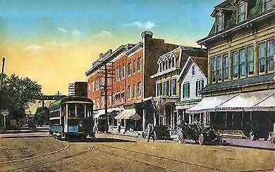
The Babylon Railroad Company began in 1870 as a horse-drawn trolley from the South Side Railroad's Babylon Station to the Fire Island Ferry. After the Central Railroad of Long Island opened in 1873 passengers could access the horse car to the Great South Bay at the Watson House. [1] A second line was opened from Babylon Station into Amityville in 1910.

NameFromRouteToNotes
Fire Island LineBabylon StationDeer Park Avenue and Fire Island Avenue to ferry at Great South Bay.Great South Bay FerryAbandoned May 15, 1920.
Amityville LineBabylon StationTrolley Line Road and Union Avenue.Amityville 1910 (station 1912)Abandoned May 15, 1920.

Cedarhurst Railway

The Cedarhurst Railway Company ran a line from Woodmere (LIRR station) to Brosewere Bay where the Rockaway Hunt Club and Rockaway Steeplechase Association were located. [2]

NameFromToRouteNotes
Cedarhurst Railway Woodsburgh Railroad Station Brosewere Bay Wood Lane, Railroad Avenue, Rutherford Lane.Abandoned 1894.

Echo Line Railroad

The Echo Line was a trolley line that ran from Port Jefferson Harbor to Port Jefferson (LIRR station) in what was then the Hamlet of Echo, New York. It was acquired by the Suffolk Traction Company to be merged into the main trolley line to Patchogue, but collapsed along with the rest of Suffolk Traction Company.

NameFromToRouteNotes
Echo Line Port Jefferson Harbor Port Jefferson Station Main Street, East Main Street, East Broadway.Abandoned in 1919.

Freeport Railroad Company

The Freeport Railroad Company owned and operated a year-round trolley route in Freeport, New York, and leased from the connecting Great South Bay Ferry Company that portion of the latter’s route between Front Street and Ellison’s dock. The Freeport Railroad Company and the Great South Bay Ferry Company were commonly controlled. Service was inaugurated on August 5, 1913. Service ended on or about November 8, 1917, and on July 13, 1918, the trolley route was sold to the Great South Bay Ferry Company.

NameFromToRouteNotes
Fishermen's Delight Freeport LIRR station Nautical Mile Grove Street (now Guy Lombardo Boulevard), Front Street, then south to Ellison's dock on Little Swift Creek, using private right-of-way between Miller Avenue and South Ocean AvenueServed the ferry to Point Lookout. Sold in 1918. Replaced by n62 bus via Guy Lombardo Blvd. (abandoned in 2017)

Garden City Shuttle

In the early-20th Century, the Long Island Rail Road installed a trolley line that ran along the former CRRLI Main Line between Garden City Station and Plainedge from 1915 to 1933. A connection to Country Life Press station was established in 1927. Trolleys were replaced by MP41's and later MP54's.

NameFromToRouteNotes
Long Island Rail RoadGarden City StationSalisbury PlainsCentral BranchTerminal changed in 1927 to Country Life Press
Long Island Rail Road Country Life Press Railroad Station Salisbury PlainsLIRR Central Branch.1933, Trolley Car replaced by MP41s, 1949 by MP54s.

Glen Cove Railroad

The Glen Cove Railroad was one of two trolley lines that ran from the Sea Cliff Railroad Station. The route was north in private right of way alongside the LIRR to Glen Street station and from there in streets on a circuitous route through the City of Glen Cove. The line existed between 1905 and November 15, 1924. [3] [4]

NameFromToRouteNotes
Glen Cove Railroad Sea Cliff Railroad Station Glen Cove Waterfront right of way, Glen Street, School Street, Cottage Row, Mill Street, The Place, Ellwood Street, Clement Street, Carpenter Street, Landing Road.Abandoned 1924. Split up between current n27 bus route, and City of Glen Cove bus loop route.

Great South Bay Ferry Company

The Great South Bay Ferry Company operated a summer-only trolley route in Freeport, New York, connecting with its ferries to and from Point Lookout, New York. Its route was initially owned by the Long Beach Transportation Company which was then leased to the Great South Bay Ferry Company for operation. Service was inaugurated on May 27, 1905, between Atlantic Avenue and Front Street; from May 26, 1906, service was extended to operate the full route between Atlantic Avenue and Ellison’s dock on Little Swift Creek. On or about March 4, 1907, the ferry company became a subsidiary of a holding company, the newly-incorporated Seashore Municipal Railroad Company. On September 27, 1907, the Long Beach Transportation Company was merged into the Great South Bay Ferry Company; thereafter the ferry company was the owner of the trolley route. The larger ambitions of the Seashore Municipal Railroad Company were not realized, and by 1913 it was practically defunct. The southern portion of the route, between Front Street and Ellison’s dock, was leased to the Freeport Railroad Company in 1913. The Great South Bay Ferry Company and the Freeport Railroad Company were commonly controlled. On July 13, 1918, the trolley route of the Freeport Railroad Company was purchased and became part of the ferry company’s summer-only trolley operations. Service probably ended on or about September 30, 1921.

NameFromToRouteNotes
Great South Bay Ferry Company Freeport Atlantic Avenue Nautical Mile Atlantic Avenue, Freeport, south to Ellison's dock on Little Swift Creek, using private right-of-way between Miller Avenue and South Ocean AvenueServed the ferry to Point Lookout. Abandoned in 1921. Currently occupied by condominiums. n62 bus via Guy Lombardo Blvd. (abandoned in 2017)
Fishermen's Delight Freeport LIRR station Nautical Mile Grove Street (now Guy Lombardo Boulevard), Front Street, then south to Ellison's dock on Little Swift Creek, using private right-of-way between Miller Avenue and South Ocean AvenueServed the ferry to Point Lookout. Purchased in 1918; abandoned in 1921. Replaced by n62 bus via Guy Lombardo Blvd. (abandoned in 2017)

Huntington Railroad

The Huntington Railroad was established on July 19, 1890 with a trolley line between Huntington Village and Halesite. It was eventually extended to Huntington Railroad Station, then along what is today mostly NY 110 through Melville, Farmingdale, and as far south as the docks of Amityville.

NameFromToRouteNotes
Huntington Railroad Halesite Amityville Wincoma Drive, East Shore Drive, New York Avenue, Walt Whitman Road, Amityville Road, Broad Hollow Road, Conklin Street, Main Street(Farmingdale), Broadway, Sterling Place, Greene Street, Bennett Place, Richmond Avenue.Service ended September 23, 1919. Current S1 bus route.

Huntington Traction Company

The Huntington Traction Company was the successor to the Huntington Railroad Company inheriting the original line between Huntington Railroad Station and Halesite. The company ran the line only as far south as Jericho Turnpike until it was finally abandoned in 1927.

NameFromToRouteNotes
Huntington Traction Company Halesite South Huntington Wincoma Drive, East Shore Drive, New York Avenue, Walt Whitman Road.Abandoned in 1927. Northern portion of current S1 route.


Nassau County Railway

The Nassau County Railway ran from the Sea Cliff Railroad Station through the Village of Sea Cliff to the top of the "cable road" incline that went down to the dock. The trolley was in operation from July 2, 1902 to December 31, 1924. [5] [6]

NameFromToRouteNotes
Sea Cliff Railroad Station Sea Cliff Landing Sea Cliff Avenue, Glen Cove Avenue, Glen Avenue, Main Avenue, Twelfth Avenue, to Prospect Avenue, near the inclineAbandoned 1924. Incorporated into current n21 bus route.

New York and Long Island Traction

The New York and Long Island Traction Company operated east to Freeport, Hempstead, and Mineola in Nassau County.

NameFromToRouteNotes
Mineola Line Queens Village (Becomes Long Island Electric Railway at the Queens-Nassau Line) Mineola Jamaica Avenue abandoned April 3, 1926
now the n24 bus
Jamaica-Hempstead Line Jamaica (Becomes Long Island Electric Railway at the Queens-Nassau Line) Freeport 160th Street Jamaica to Belmont Park on 160th Street, Jamaica Avenue, and Hempstead Avenue(Turnpike)Joint NY&LI-LIER service; abandoned April 3, 1926 Current n6 bus.
Brooklyn-Freeport Line Brooklyn (Becomes Long Island Electric Railway at the Queens-Nassau Line) Freeport Rockaway Boulevard, North Conduit Avenue, and Sunrise Highway abandoned April 3, 1926 Current n4 & n36 bus.


New York and North Shore Traction

The New York and North Shore Traction Company operated from northeastern Queens east into Nassau County. It was established in 1902 and was originally known as the "Mineola Roslyn & Port Washington Traction Company," then renamed 1907.

NameFromToRouteNotes
North Shore Line Flushing, Queens Roslyn 35th Avenue, 39th Avenue, and Northern Boulevard abandoned 1920
now the n20 bus
Port Washington Line Port Washington Mineola Main Street (Port Washington), Port Washington Boulevard, Middle Neck Road, Old Northern Boulevard, Main Street (Roslyn), Roslyn Road, Railroad Avenue, Roslyn (LIRR station), Warner Avenue, Mineola Avenue, Willis Avenue.abandoned 1920
Now the n23 bus.
Hicksville Line Mineola Hicksville Westbury Avenue, Maple Avenue, Post Road, Union Avenue, Prospect Avenue, West John Street.abandoned 1920
Includes part of the n22 bus.

Northport Traction Company

The Northport Traction Company operated from the Northport East Railroad Station into downtown Northport Village.

NameFromToRouteNotes
Northport Traction Company Northport East Station Northport Village Larkfield Avenue, Laurel Avenue, Main Street, Woodbine(Cherry) Avenue by Northport Harbor.abandoned 1924
now includes some of the HART H40 bus route.


South Shore Traction Company

The South Shore Traction Company was based in Sayville, New York. It had plans to expand into Patchogue and north through Bohemia, Lake Ronkonkoma, St. James and Stony Brook towards Port Jefferson, not to mention through Nassau and Queens County. However, because it was unable to break through the monopoly of the LIRR-held lines in Nassau County, it sold off its two original lines to the Suffolk Traction Company.

NameFromToRouteNotes
Sayville Railroad Station Sayville at the Great South Bay Railroad Avenue, Montauk Highway, Candee AvenueAcquired by Suffolk Traction Company, then abandoned. Part of current S57/S59 bus route.
Bayport-Blue Point Line Sayville Railroad Station Blue Point Middle Road, Oakwood Avenue, Railroad Street/Maple Street, Blue Point Avenue, Montauk Highway Acquired by Suffolk Traction Company, then abandoned. Part of S40 bus route.

Suffolk Traction Company

The Suffolk Traction Company operated between Patchogue, Canaan Lake, and Holtsville in Suffolk County. It also had lines to Medford, Blue Point, Bayport, and even a connection to Sayville. The Sayville, and Bayport-Blue Point Lines were originally owned by the South Shore Traction Company. Plans to extend the main trolley to Port Jefferson failed, even as a bridge was being built over the LIRR Main Line. Another extension that was never built included a line towards Bellport and Brookhaven.

NameFromToRouteNotes
Main Line Patchogue Railroad Station Holtsville South Ocean Avenue, North Ocean Avenue, Old North Ocean Avenue, Suffolk Traction Boulevard Abandoned. Segments of the ROW no longer exist north of the Canaan Lake neighborhood. Part of current S63 bus route.
Medford Line Patchogue Railroad Station Medford Unknown(Presumably, the current NY 112).Abandoned. Part of current S61 bus route.
Bayport-Blue Point Line Sayville Railroad Station Patchogue at Medford Avenue Middle Road, Oakwood Avenue, Railroad Street/Maple Street, Blue Point Avenue, Montauk Highway Abandoned. Served Bayport, Blue Point, and went as far east as what is today NY 112. Part of current S40 bus route.
Sayville Line Sayville Railroad Station Sayville at the Great South Bay Railroad Avenue, Montauk Highway, Candee AvenueAbandoned. Part of current S57/S59 bus route.


See also

Related Research Articles

The Babylon Rail Road was a horsecar line in Babylon Village, New York, later converted to a trolley line. It was opened in 1871 and ceased operations in 1920.

<span class="mw-page-title-main">Woodmere station</span> Long Island Rail Road station in Nassau County, New York

Woodmere is a station on the Long Island Rail Road's Far Rockaway Branch in Woodmere, in the Town of Hempstead in Nassau County, New York, United States. The station is located at Woodmere Boulevard and Cedar Lane, between Central Avenue and West Broadway.

<span class="mw-page-title-main">Far Rockaway station (LIRR)</span> Long Island Rail Road station in Queens, New York

Far Rockaway is the terminus of the Long Island Rail Road's Far Rockaway Branch in the Far Rockaway neighborhood of Queens in New York City. The station is located at Nameoke Avenue and Redfern Avenue.

<span class="mw-page-title-main">Montauk Branch</span> Long Island Rail Road branch

The Montauk Branch is a rail line owned and operated by the Long Island Rail Road in the U.S. state of New York. The line runs the length of Long Island, 115 miles (185 km) from Long Island City to Montauk. However, in LIRR maps and schedules for public use, the term Montauk Branch refers to the line east of Babylon; service from Jamaica to Babylon is covered by separate Babylon Branch schedules, while the line west of Jamaica is currently unused for passenger service. A select number of Montauk Branch trains operate via the Main Line during peak hours.

The Suffolk Traction Company is a former streetcar system in Suffolk County, New York. It operated primarily between Patchogue and Holtsville, but also included a route that served Blue Point, Bayport, and Sayville. It was opened in 1909 and ceased operations in 1919.

The South Side Railroad of Long Island was a railroad company in the U.S. state of New York. Chartered in 1860 and first opened in 1867 as a competitor to the Long Island Rail Road, it was reorganized in 1874 as the Southern Railroad of Long Island and leased in 1876 to the LIRR. After a reorganization as the Brooklyn and Montauk Railroad in 1879 it was merged in 1889.

<span class="mw-page-title-main">Patchogue station</span> Long Island Rail Road station in Suffolk County, New York

Patchogue is a station of the Montauk Branch of the Long Island Rail Road in Patchogue, New York. It is on Division Street between West Avenue and South Ocean Avenue. The station is the eastern terminus for some trains on the branch.

<span class="mw-page-title-main">Sayville station</span> Long Island Rail Road station in Suffolk County, New York

Sayville is a station on the Montauk Branch of the Long Island Rail Road in the village of Sayville, New York, on Depot Street between Greeley Avenue and Railroad Avenue. Ferries to Fire Island board from a port south of the station.

The Long Island Rail Road is a railroad owned by the Metropolitan Transportation Authority in the U.S. state of New York. It is the oldest United States railroad still operating under its original name and charter. It consolidated several other companies in the late 19th century. The Pennsylvania Railroad owned the Long Island Rail Road for the majority of the 20th century and sold it to the State in 1966.

<span class="mw-page-title-main">Northport station</span> Long Island Rail Road station in Suffolk County, New York

Northport is a station on the Port Jefferson Branch of the Long Island Rail Road. It is located at the corner of Larkfield Road and Bellerose Avenue, north of Suffolk CR 11 in East Northport, Suffolk County, New York.

<span class="mw-page-title-main">Bayport station</span> Railroad station in New York, US

Bayport was a station stop along the Montauk Branch of the Long Island Rail Road. It was located on Railroad Street between Oakwood and Snedecor Avenues in Bayport, New York, and was the easternmost station along the Montauk Branch in the Town of Islip.

<span class="mw-page-title-main">Blue Point station</span> Railway station in Blue Point, the United States of America

Blue Point was a station stop along the Montauk Branch of the Long Island Rail Road It was located on Martha Avenue on the south side of the tracks in Blue Point, New York, and was the westernmost station along the Montauk Branch in the Town of Brookhaven. Access to the station was through a driveway that emptied onto Blue Point Avenue. The station was originally opened on February 1, 1870, by the South Side Railroad of Long Island and closed on June 1, 1882. The second depot opened around June, 1900, evidently in conjunction with the bridge over Blue Point Avenue. The newer station also had a connection to the South Shore Traction Company trolleys, which were later replaced by Suffolk Traction Company trolleys. Blue Point station closed on September 6, 1980. It was located between Bayport and Patchogue stations, the former of which also closed on the same day. It was located between Bayport and Patchogue stations. The former station site, across from the Blue Point Wine & Liquor store, remains, to this day, gated off, and covered partially in trees, leaves, and weeds. Somewhat recently, the former site has been used by LIRR workers as a storage yard for road vehicles and equipment, being cleaned up in the process.

The Huntington Railroad was established on July 19, 1890 with a trolley line between Huntington Village and Halesite on Long Island, New York. It was eventually extended to Huntington Railroad Station, then along what is today mostly NY 110 through Melville, Farmingdale, and as far south as the docks of Amityville. Huntington Railroad had only one line throughout its history, although the length varied through the years.

<span class="mw-page-title-main">Northport Traction Company</span>

Northport Traction Company was a trolley service in the Town of Huntington in New York. It ran from 1902 to 1924 and served East Northport and Northport, New York. The company only had one line throughout its history which ran from Northport to Northport Harbor, at what is today Cow Harbor Park. Unlike Huntington Railroad to the west, Northport Traction Company never expanded beyond either Northport or East Northport, and no record exists of any proposal to do so.

Hammels was a Long Island Rail Road station on the Rockaway Beach Branch in Hammels, Queens. It was located at what is today Beach 84th Street at the west leg of the Hammels Wye.

The White Line was a short-lived branch of the Long Island Rail Road in western Queens County, New York. Officially known as the Newtown and Flushing Railroad, the line was chartered in 1871, but was only in service from 1873 to 1876.

The Manhattan and Queens Traction Company, also known as the Manhattan and Queens Transit Company, was a streetcar company operating in Manhattan and Queens County, New York between 1913 and 1937.

References

  1. To Fire Island - The Watson House: The Babylon Rail Road (Arrt's Arrchives)
  2. Cedarhurst Railway Company; LIRR Cedarhurst Branch (Arrt's Arrchives)
  3. Victorian Stations of the Long Island Railroad (Sam Berliner III)
  4. E. Belcher-Hyde, Atlas of Nassau County Long Island N.Y. Complete in One Volume, 1914, double page 5, page 101
  5. Victorian Stations of the Long Island Railroad (Sam Berliner III)
  6. E. Belcher-Hyde, Atlas of Nassau County Long Island N.Y. Complete in One Volume, 1914, double page 11 and page 28