
23rd Street is a broad thoroughfare in the New York City borough of Manhattan, one of the major two-way, east-west streets in the borough's grid. As with Manhattan's other "crosstown" streets, it is divided into its east and west sections at Fifth Avenue. The street runs from Avenue C and FDR Drive in the east to Eleventh Avenue in the west.
The Forty-second Street and Grand Street Ferry Railroad was a horse-drawn streetcar line in Manhattan, New York City, United States. It ran from the 42nd Street Ferry on the Hudson River to the Grand Street Ferry on the East River. The line was distinguished by a light green light.

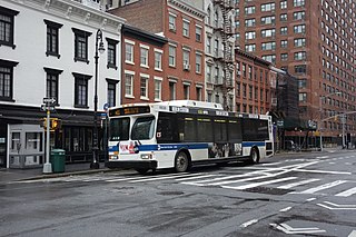
The 23rd Street Crosstown is a surface transit line on 23rd Street in Manhattan, New York City. It currently hosts the M23 SBS bus route of the Metropolitan Transportation Authority (MTA)'s Regional Bus Operations. The M23 runs between Chelsea Piers, along the West Side Highway near 22nd Street, via 23rd Street, to Avenue C and 20th Street in Stuyvesant Town–Peter Cooper Village.

The Third Avenue Railway System (TARS), founded 1852, was a streetcar system serving the New York City boroughs of Manhattan and the Bronx along with lower Westchester County. For a brief period of time, TARS also operated the Steinway Lines in Long Island City.
The Ninth and Tenth Avenues Line or Ninth Avenue Line is a surface transit line in the New York City borough of Manhattan, running mostly along Ninth Avenue and Amsterdam Avenue from Lower Manhattan to Manhattanville. Originally a streetcar line operated by the Manhattan and Bronx Surface Transit Operating Authority, it is now the M11 bus route operated by the New York City Transit Authority.

The M5 and M55 bus routes constitute a public transit corridor in Manhattan, New York City, running along the Fifth / Sixth Avenues / Riverside Drive Line as well as the southern portion of the Broadway Line after the discontinuation of the M6. The routes primarily run along Broadway, Fifth and Sixth Avenues, and Riverside Drive from South Ferry, Lower Manhattan to Washington Heights. The M5 covers the northern portion of the route north of 31st Street, while the M55 operates along the southern portion of the route south of 44th Street. The two routes overlap in Midtown Manhattan. The portion along Broadway south of East 8th Street was originally a streetcar line.
The Eighth and Ninth Streets Crosstown is a public transit line in Manhattan, New York City, running mostly along Eighth Street, Ninth Street, Tenth Street, and Christopher Street through the West Village, Greenwich Village, and East Village. Originally a streetcar line, it is now the M8 bus route, operated by the New York City Transit Authority.

The Columbus Avenue Line is a public transit line in Manhattan, New York City, running mostly along Columbus Avenue, 116th Street, and Lenox Avenue from Lower Manhattan to Harlem. Originally a streetcar line, it is now the M7 bus route, operated by the New York City Transit Authority, a division of the Metropolitan Transportation Authority.
The Bleecker Street Line was a public transit line in Manhattan, New York City, United States, running mostly along Bleecker Street, Crosby Street, and Lafayette Street from the West 14th Street Ferry in Chelsea to the Fulton Ferry in the Financial District. It was the last horse car line in New York City, and was not replaced with a trolley line or bus route when it was abandoned in 1917.
The 17th and 18th Streets Crosstown Line was a public transit line in Manhattan, New York City, United States, running mostly along 14th Street, 17th Street, and 18th Street from the West 14th Street Ferry in Chelsea and Christopher Street Ferry in the West Village to the East 23rd Street Ferry at Peter Cooper Village. It was not replaced with a trolley line or bus route when it was abandoned in 1913.

The M9 is a local bus route that operates along the Avenue C Line, in Manhattan, New York City. The route runs mostly along Essex Street and Avenue C from Battery Park City to Kips Bay. Originally a streetcar line, the Avenue C Line is now part of the M9 route, as well as the M21, which operates on the Houston Street Line. Both the Avenue C and Houston Street segments were served by a single route, the M21, until June 2010. The M9 and M21 are operated by the New York City Transit Authority, and based out of the Michael J. Quill Depot.

The Nassau Electric Railroad was an electric street railway company in the U.S. state of New York. The company operated throughout the borough of Brooklyn, as well as over the Brooklyn Bridge and Williamsburg Bridge into Manhattan.
The New York Railways Company operated street railways in Manhattan, New York City, United States between 1911 and 1925. The company went into receivership in 1919 and control was passed to the New York Railways Corporation in 1925 after which all of its remaining lines were replaced with bus routes.
The Seventh Avenue Line is a surface public transit line in Manhattan, New York City, United States, connecting Lower Manhattan with Central Park along Seventh Avenue. Once a streetcar line, it is now part of the southbound direction of the M10 and M20 bus routes.

The Broadway Line is a surface transit line in Manhattan, New York City, running mainly along 42nd Street and Broadway from Murray Hill to Harlem. Formerly a streetcar line operated by the Third Avenue Railway, it is now the M104 bus route operated by the New York City Transit Authority, a subsidiary of the Metropolitan Transportation Authority. This bus route no longer runs along the entire route of the former streetcar.
The 53rd Street Crosstown Line was a surface transit line in Manhattan, New York City, United States, running along 53rd Street in Midtown, between Sixth Avenue and Ninth Avenue. It served as a connection between north-south lines during the times that they were not affiliated with the 59th Street Crosstown Line. The street is no longer used by buses, which now use 59th Street to make the crosstown connection.
The Lenox Avenue Line is a surface transit line on Lenox Avenue in Harlem, Manhattan, New York City, United States. The line was once operated separately, but later became the northern end of the Broadway and Columbus Avenue Line and Broadway and Lexington Avenue Line, now the M7 and M102 bus routes.

The 86th Street Crosstown Line is a bus line in Manhattan, New York City, running mostly along 86th Street on the Upper West and Upper East Sides of Manhattan. Originally a streetcar line, it now comprises the M86 Select Bus Service bus line.