Related Research Articles
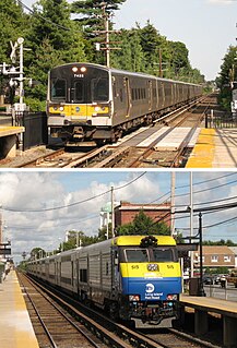
The Long Island Rail Road, often abbreviated as the LIRR, is a commuter rail system in the southeastern part of the U.S. state of New York, stretching from Manhattan to the eastern tip of Suffolk County on Long Island. With an average weekday ridership of 354,800 passengers in 2016, it is the busiest commuter railroad in North America. It is also one of the world's few commuter systems that runs 24/7 year-round. It is publicly owned by the Metropolitan Transportation Authority, which refers to it as MTA Long Island Rail Road.
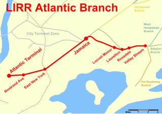
The Atlantic Branch is an electrified rail line owned and operated by the Long Island Rail Road in the U.S. state of New York. It is the only LIRR line that runs in the borough of Brooklyn.

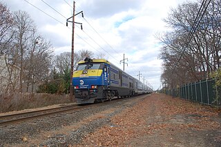
The Montauk Branch is a rail line owned and operated by the Long Island Rail Road in the U.S. state of New York. The branch runs the length of Long Island, 115 miles (185 km) from Long Island City on the west to Montauk on the east. However, in LIRR maps and schedules for public use the term Montauk Branch refers to the line east of Babylon; the line west of there is covered by Babylon Branch schedules, and a few Montauk Branch trains operate via the Main Line west of Babylon due to increased track capacities.
The Suffolk Traction Company is a former streetcar system in Suffolk County, New York. It operated primarily between Patchogue and Holtsville, but also included a route that served Blue Point, Bayport, and Sayville. It was opened in 1909 and ceased operations in 1919.

Patchogue is a station of the Montauk Branch of the Long Island Rail Road in the village of Patchogue, New York. It is on Division Street between West Avenue and South Ocean Avenue. This train station is located in the Patchogue-Medford Union Free School District.
Vincent Francis Seyfried was an American historian of Long Island. His work between 1950 and 2010 includes eleven books on trolley systems in Queens and Long Island, twelve books on areas of Queens, a seven-volume set on the Long Island Rail Road, and a history of the founding of Garden City, where he was Village Historian from 1987 to 2006. He provided many entries on Queens history for The Encyclopedia of New York City (1995).

Sayville is a station on the Montauk Branch of the Long Island Rail Road in the village of Sayville, New York, on Depot Street between Greeley Avenue and Railroad Avenue. Ferries to Fire Island board from a port south of the station.
The North Shore Bus Company operated public buses in Queens, New York City. It was established in 1920 as the successor to the New York and North Shore Traction Company trolley system, and operated until 1947 when it went bankrupt, and its operations were taken over by the New York City Board of Transportation.
The Long Island Rail Road is a railroad owned by the Metropolitan Transportation Authority in the U.S. state of New York. It is the oldest United States railroad still operating under its original name and charter. It consolidated several other companies in the late 19th century. The Pennsylvania Railroad owned the Long Island Rail Road for the majority of the 20th century and sold it to the State in 1966.

Nearly every major type of transportation serves Long Island, including three major airports, railroads and subways, and several major highways. The New York City Subway only serves the New York City boroughs of Brooklyn and Queens. There are historic and modern bridges, recreational and commuter trails, and ferries, that connect the boroughs of Queens and Brooklyn to Manhattan, the south shore with Fire Island and Long Island's north shore and east end with the state of Connecticut.
Central Railroad of Long Island was built on Long Island, New York, by Alexander Turney Stewart, who was also the founder of Garden City. The railroad was established in 1871, then merged with the Flushing and North Side Railroad in 1874 to form the Flushing, North Shore and Central Railroad. It was finally acquired by the Long Island Rail Road in 1876 and divided into separate branches. Despite its short existence, the CRRLI had a major impact on railroading and development on Long Island.
Bayport was a station stop along the Montauk Branch of the Long Island Rail Road. It was located on Railroad Street between Oakwood and Snedecor Avenues in Bayport, New York, and was the easternmost station along the Montauk Branch in the Town of Islip.
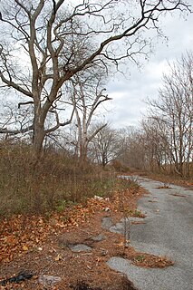
Blue Point was a station stop along the Montauk Branch of the Long Island Rail Road It was located on Martha Avenue on the south side of the tracks in Blue Point, New York, and was the westernmost station along the Montauk Branch in the Town of Brookhaven. Access to the station was through a driveway that emptied onto Blue Point Avenue. The station was originally opened on February 1, 1870, by the South Side Railroad of Long Island and closed on June 1, 1882. The second depot opened around June, 1900, evidently in conjunction with the bridge over Blue Point Avenue. The newer station also had a connection to the South Shore Traction Company trolleys, which were later replaced by Suffolk Traction Company trolleys. Blue Point station closed on September 6, 1980, in conjunction with the nearby Bayport Station. It was located between Bayport and Patchogue stations. The former station site, across from the Blue Point Wine & Liquor store, remains, to this day, gated off, and covered partially in trees, leaves, and weeds.
The Huntington Railroad was established on July 19, 1890 with a trolley line between Huntington Village and Halesite. It was eventually extended to Huntington Railroad Station, then along what is today mostly NY 110 through Melville, Farmingdale, and as far south as the docks of Amityville. Huntington Railroad had only one line throughout its history, although the length varied through the years.
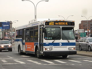
The Q60 bus route constitutes a public transit line running primarily along Queens Boulevard in Queens, New York City, extending from Jamaica into Midtown Manhattan. It is city-operated under the MTA Bus Company brand of MTA Regional Bus Operations.

The Q111, Q113, and Q114 bus routes constitute a public transit line between the Jamaica and Far Rockaway neighborhoods of Queens, New York City, running primarily along Guy R. Brewer Boulevard. The Q113 and Q114 provide limited-stop service between Jamaica and Far Rockaway, connecting two major bus-subway hubs, and crossing into Nassau County. The Q111 provides local service exclusively within Queens, with the exception of select rush-hour trips to or from Cedarhurst in Nassau County. Some of the last bus routes to be privately operated in the city, they are currently operated by the MTA Bus Company brand of MTA Regional Bus Operations. The Q113 and Q114 are one of the few public transit options between the Rockaway peninsula and "mainland" New York City.
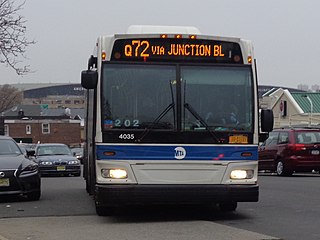
The Q72 bus route constitutes a public transit route along Junction Boulevard and 94th Street in Queens, New York City. It operates between the Rego Park and East Elmhurst neighborhoods of Queens, and extends into LaGuardia Airport at the north end of the borough. It is city-operated under the MTA Bus Company brand of MTA Regional Bus Operations.

The Q65 bus route constitutes a public transit line in Queens, New York City. The south-to-north route runs primarily on 164th Street, operating between two major bus-subway hubs: Sutphin Boulevard–Archer Avenue station in Jamaica and Flushing–Main Street station in Flushing. It then extends north along College Point Boulevard to College Point at the north end of the borough. The route is city-operated under the MTA Bus Company brand of MTA Regional Bus Operations.
References
- ↑ Seyfried, Vincent F. (1950). "New York and Queens County Railway and the Steinway Lines, 1867-1939". Vincent F. Seyfried. Retrieved December 20, 2015– via archive.org.
- Meyers, Stephen L. (2006). Lost Trolleys of Queens and Long Island. Images of Rail.