Sunset Beach, North Carolina

Last updated

Sunset Beach, North Carolina
SeagullOverWave.jpg
Seagull over wave in Sunset Beach
Sunset Beach, NC Town Seal.jpg
USA North Carolina location map.svg
Red pog.svg
Sunset Beach
Location within the state of North Carolina
Coordinates: 33°52′22″N78°29′36″W / 33.87278°N 78.49333°W / 33.87278; -78.49333
Country United States
State North Carolina
County Brunswick
Township Shallotte Township
Area
[1]
  Total7.88 sq mi (20.42 km2)
  Land6.97 sq mi (18.05 km2)
  Water0.92 sq mi (2.37 km2)
Elevation
[2]
33 ft (10 m)
Population
 (2020)
  Total4,175
  Density599.17/sq mi (231.33/km2)
Time zone UTC-5 (Eastern (EST))
  Summer (DST) UTC-4 (EDT)
ZIP code
28468
Area codes 910, 472
FIPS code 37-65900 [3]
GNIS feature ID2406693 [2]
Website www.sunsetbeachnc.gov

Sunset Beach is a seaside town in Brunswick County, North Carolina, United States. The population was 3,572 at the 2010 census, [4] up from 1,824 in 2000 census. It is part of the Wilmington, NC Metropolitan Statistical Area.

Contents

History

The seaside town of Sunset Beach got its start in 1955 when the land it occupies was bought by Mannon C. Gore. Impressed by the sunsets the southeast-facing island offered, he renamed 'Bald Beach,' as it had been called previously, to 'Sunset Beach.' Development began in earnest with the completion of a bridge connecting the beach island to the mainland in 1958 [5] , modeled by Gore and operated by him until 1961 when it was taken over by the North Carolina Department of Transportation. With the help of his son, Edward, Gore began selling property on the island in 1958. Additionally, Gore built the original pier on the island, named the 'Vesta Pier' for the beached civil war blockade-runner which sat beneath the structure, though is now completely covered by sand. [6] Sunset Beach was later incorporated as a town in 1963. [7]

On February 15, 2021, an EF3 tornado hit the north side of town around midnight, damaging multiple homes in several neighborhoods, including some that were completely destroyed. Three people were killed and 10 others were injured. [8] [9]

Geography

Sunset Beach is located in southwestern Brunswick County. It is the last developed Atlantic Ocean beach before the South Carolina border. One-third of the town's area occupies a barrier island between the ocean and the Intracoastal Waterway; the remainder of the town extends onto the mainland to the north. Undeveloped Bird Island is directly to the west, Calabash is the closest town to the west on the mainland, and Ocean Isle Beach is to the east.

According to the United States Census Bureau, the town of Sunset Beach has a total area of 7.3 square miles (19.0 km2), of which 6.4 square miles (16.7 km2) is land, and 0.89 square miles (2.3 km2) (12.22%) is water. [4]

Demographics

Historical population
CensusPop.Note
1970 108
1980 304181.5%
1990 3112.3%
2000 1,824486.5%
2010 3,57295.8%
2020 4,17516.9%
U.S. Decennial Census [10]

2020 census

Sunset Beach racial composition [11]
RaceNumberPercentage
White (non-Hispanic)3,93594.25%
Black or African American (non-Hispanic)260.62%
Native American 130.31%
Asian 340.81%
Pacific Islander 50.12%
Other/Mixed 661.58%
Hispanic or Latino 962.3%

As of the 2020 United States census, there were 4,175 people, 2,014 households, and 1,289 families residing in the town.

2000 census

As of the census [3] of 2000, there were 1,824 people, 909 households, and 678 families residing in the town. The population density was 360.9 inhabitants per square mile (139.3/km2). There were 2,983 housing units at an average density of 590.3 per square mile (227.9/km2). The racial makeup of the town was 97.37% White, 0.49% African American, 0.38% Native American, 0.38% Asian, 0.27% from other races, and 1.10% from two or more races. Hispanic or Latino of any race were 1.37% of the population.

There were 909 households, out of which 7.6% had children under the age of 18 living with them, 70.0% were married couples living together, 3.3% had a female householder with no husband present, and 25.4% were non-families. 21.3% of all households were made up of individuals, and 9.2% had someone living alone who was 65 years of age or older. The average household size was 2.01 and the average family size was 2.28.

In the town, the population was spread out, with 6.9% under the age of 18, 2.7% from 18 to 24, 12.1% from 25 to 44, 43.6% from 45 to 64, and 34.7% who were 65 years of age or older. The median age was 60 years. For every 100 females, there were 97.2 males. For every 100 females age 18 and over, there were 95.2 males.

The median income for a household in the town was $47,356, and the median income for a family was $57,019. Males had a median income of $40,795 versus $27,708 for females. The per capita income for the town was $36,181. About 3.0% of families and 4.2% of the population were below the poverty line, including 3.5% of those under age 18 and 3.2% of those age 65 or over.

Sunset Beach Bridge

Sunset beach bridge Sunset Beach Bridge East view.JPG
Sunset beach bridge
Sunset beach bridge 2006 with cars Sunset Beach Bridge with cars.JPG
Sunset beach bridge 2006 with cars

Since most of Sunset Beach and the adjoining Bird Island coastal reserve encompass a barrier island, the only way to get there from the mainland was by crossing a pontoon bridge (swing bridge) straddling the Intracoastal Waterway and adjacent marshland. It was a wooden structure that could only hold one lane of traffic at any given time, and was the only one of its kind still in use along the East Coast until 2010. During the day in the summer, traffic would be stopped every hour, on the hour, and the bridge would open to boat traffic on the waterway for 10 minutes. At 10 minutes after the hour, every hour, the bridge would reopen for vehicular traffic again for 50 minutes. During the off-season, the bridge only opened at the request of boat traffic. While this caused headaches for those trying to get on or off the island, many locals said the bridge did, however, give the town a more relaxed feel. Historically, this had been in stark contrast to the rapid growth affecting other beach communities along the Grand Strand.

In February 2008 the NCDOT started construction to replace the old bridge with a modern, 65-foot-high (20 m) arc bridge (non-draw, non-swing). The bridge opened November 11, 2010. The old Sunset Beach pontoon swing bridge was saved by the Old Bridge Preservation Society which plans to create a museum celebrating the old bridge and the town's history. [12] The new bridge eliminates the need for a bridge keeper and provides for a continual flow of vehicle traffic on and off the island, and water traffic on the Intracoastal Waterway. [13]

Sunset Beach Beach Houses at Dusk Sunset Beach at dusk.JPG
Sunset Beach Beach Houses at Dusk
A beach house at Sunset Beach, NC named "SandTrap" "SandTrap" Beach house.JPG
A beach house at Sunset Beach, NC named "SandTrap"

Housing in Sunset Beach

The town consists of both mainland neighborhoods and a barrier island of approximately 1,200 homes. Three of the larger mainland neighborhoods in the town are golf course developments at Oyster Bay, Sea Trail Resort and Sandpiper Bay. Ocean Ridge Plantation, while not in the town limits, has one of its "sister communities" in Sunset Beach's ETJ. Ocean Ridge has an amenities center/clubhouse on the island, while Sea Trail Home Owners Association has a designated parking lot for members. The island is primarily home to vacation rental homes and cottages, although there are close to 100 full-time residents as well.

Related Research Articles

<span class="mw-page-title-main">Georgetown County, South Carolina</span> County in South Carolina, United States

Georgetown County is a county located in the U.S. state of South Carolina. As of the 2020 census, the population was 63,404. Its county seat is Georgetown. The county was founded in 1769. It is named for George III of the United Kingdom.

<span class="mw-page-title-main">Pamlico County, North Carolina</span> County in North Carolina, United States

PamlicoCounty is a county located in the U.S. state of North Carolina. As of the 2020 census, the population was 12,276. Its county seat is Bayboro.
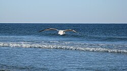
<span class="mw-page-title-main">Currituck County, North Carolina</span> County in North Carolina, United States

Currituck County is the northeasternmost county in the U.S. state of North Carolina. As of the 2020 census, the population was 28,100. Its county seat is Currituck. The county was formed in 1668 as a precinct of Albemarle County and later gained county status in 1739. The name is "traditionally said to be an indigenous word for wild geese; Coratank." Currituck County is included in the Virginia Beach-Chesapeake, VA-NC Combined Statistical Area. It is in the northeastern section of the state and is bounded by the Atlantic Ocean, Currituck Sound, Camden County, Dare County and the Commonwealth of Virginia. Currituck Court House, mentioned as early as 1755, was the name of the county seat. Today the words "Court House" have been dropped and only Currituck is used as the community name.

<span class="mw-page-title-main">Brunswick County, North Carolina</span> County in North Carolina, United States

Brunswick County is the southernmost county in the U.S. state of North Carolina. As of the 2020 census, the population was 136,693. Its population was only 73,143 in 2000, making it one of the fastest-growing counties in the state. With a nominal growth rate of approximately 47% in ten years, much of the growth is centered in the eastern section of the county in the suburbs of Wilmington such as Leland, Belville and Southport. The county seat is Bolivia, which at a population of around 150 people is among the least populous county seats in the state.

<span class="mw-page-title-main">Lauderdale-by-the-Sea, Florida</span> Town in the state of Florida, United States

Lauderdale-by-the-Sea is a town in Broward County, Florida, United States, situated 33 miles north of Miami. The town is part of the South Florida metropolitan area. As of the 2020 census, the population was 6,198.

<span class="mw-page-title-main">Beverly Beach, Florida</span> Town in Florida, United States

Beverly Beach is a town in Flagler County, Florida, United States. The population was 338 at the 2010 census, down from 547 in 2000. It is part of the Deltona–Daytona Beach–Ormond Beach, FL metropolitan statistical area.

<span class="mw-page-title-main">Golden Beach, Florida</span> Town in Florida

Golden Beach is a town in Miami-Dade County, Florida, United States, between the Intracoastal Waterway and Atlantic Ocean. The town is part of the Miami metropolitan area of South Florida. As of the 2020 US census, the town had a population of 961.

<span class="mw-page-title-main">Madeira Beach, Florida</span> City in Florida, United States

Madeira Beach is a city in Pinellas County, Florida, United States, bordered on the west by the Gulf of Mexico, and on the east by St. Petersburg. As of the 2020 census, the population was 3,895. The entertainment district of John's Pass is located on the Intracoastal Waterway. The city is often referred to by locals as Mad Beach. It is named after the Portuguese island of Madeira.

<span class="mw-page-title-main">Holden Beach, North Carolina</span> Seaside town in North Carolina, United States

Holden Beach is a seaside town in Brunswick County, North Carolina. The population was 575 at the time of the 2010 census. It is part of the Wilmington, NC Metropolitan Statistical Area.

<span class="mw-page-title-main">Oak Island, North Carolina</span> Town in North Carolina, United States

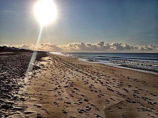
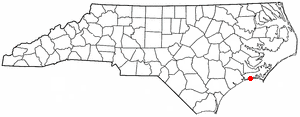
Oak Island is a seaside town located in the southeastern corner of North Carolina, United States. Part of Brunswick County, the major portion of the town is on Oak Island which it shares with Caswell Beach. Founded in 1999 as the result of the consolidation of two existing towns, Oak Island's main industry is tourism. Per the 2020 census, the town has a permanent population of 8,396 while its summer population is near 50,000. It along with the town of Caswell Beach is part of the Wilmington, NC, Metropolitan Statistical Area.

<span class="mw-page-title-main">Ocean Isle Beach, North Carolina</span> Town in North Carolina, United States

Ocean Isle Beach is a small seaside town in Brunswick County, North Carolina, United States. It was incorporated as a town in 1959 and is part of the Wilmington, NC Metropolitan Statistical Area. The population was 867 at the 2020 census. Located at the southern end of North Carolina's Atlantic coastline, along the Atlantic Intracoastal Waterway, Ocean Isle Beach has private homes, seasonal rentals, and tourist attractions.

<span class="mw-page-title-main">Atlantic Beach, North Carolina</span> Town in North Carolina, United States

Atlantic Beach is a town in Carteret County, North Carolina, United States. It is one of the five communities located on Bogue Banks. The population was 1,364 at the 2020 census.

<span class="mw-page-title-main">Emerald Isle, North Carolina</span> Town in North Carolina, United States

Emerald Isle is a town in Carteret County, North Carolina, United States. It is part of the Crystal Coast and is located entirely on Bogue Banks. The population was 3,847 at the 2020 census, but as many as 50,000 tourists each week inhabit the area during the summer season, filling up vacant rental properties that do not count toward official census results.

<span class="mw-page-title-main">Indian Beach, North Carolina</span> Town in North Carolina, United States

Indian Beach is a town in Carteret County, North Carolina, United States. The population was 223 as of the 2020 census.

<span class="mw-page-title-main">Pine Knoll Shores, North Carolina</span> Town in North Carolina, United States

Pine Knoll Shores is a coastal town in Carteret County, North Carolina, United States. The population was 1,388 at the 2020 census. One of North Carolina's state aquariums is located here.

<span class="mw-page-title-main">Wrightsville Beach, North Carolina</span> Town in North Carolina, United States

Wrightsville Beach is a town in New Hanover County, North Carolina, United States. Wrightsville Beach is just east of Wilmington and is part of the Wilmington Metropolitan Statistical Area. The population was 2,477 at the 2010 census. The town consists of a 4-mile (6 km) long beach island, an interior island called Harbor Island, and pockets of commercial property on the mainland. It served as a filming location of Dawson's Creek.

<span class="mw-page-title-main">Swansboro, North Carolina</span> Town in North Carolina, United States

Swansboro is a town in Onslow County, North Carolina, United States, located along the Atlantic Ocean. In 2010, the population was 2,663. By 2021, the population had grown to 3,825.

<span class="mw-page-title-main">Isle of Palms, South Carolina</span> Barrier island on the coast of South Carolina, United States

Isle of Palms is a city in Charleston County, South Carolina, United States. At the 2010 census, the population was 4,133. Isle of Palms is a barrier island on the South Carolina coast. The city is included within the Charleston-North Charleston-Summerville metropolitan area and the Charleston-North Charleston Urbanized Area. The town lies along a narrow strip of land, hugging the beach, separated from the mainland by the Intracoastal Waterway. It is a community of both vacation home owners and year-round residents, with large beachfront homes, resorts, and local restaurants. Beach volleyball is popular in the summer, and the "Windjammer" club hosts several tournaments throughout the year.

<span class="mw-page-title-main">Bucksport, South Carolina</span> Census-designated place in South Carolina, United States

Bucksport is an unincorporated community and census-designated place (CDP) in Horry County, South Carolina, United States. The population was 876 at the 2010 census. It is a rural port on the Atlantic Intracoastal Waterway at the merger point with the Waccamaw River. The port has some services available for boaters and is also home to the Bucksport Restaurant.

<span class="mw-page-title-main">Surf City, North Carolina</span> Town in North Carolina, United States

Surf City is a town in Onslow and Pender counties in the U.S. state of North Carolina. The population was 3,867 at the 2020 census. It is located on Topsail Island.

References

  1. "ArcGIS REST Services Directory". United States Census Bureau. Retrieved September 20, 2022.
  2. 1 2 U.S. Geological Survey Geographic Names Information System: Sunset Beach, North Carolina
  3. 1 2 "U.S. Census website". United States Census Bureau . Retrieved January 31, 2008.
  4. 1 2 "Geographic Identifiers: 2010 Demographic Profile Data (G001): Sunset Beach town, North Carolina". U.S. Census Bureau, American Factfinder. Archived from the original on February 12, 2020. Retrieved February 12, 2014.
  5. "The History of Sunset Beach". Sunset Beach, North Carolina. Retrieved May 27, 2014.
  6. "Sunset Beach History". Town of Sunset Beach, NC. October 1, 2010. Retrieved December 29, 2023.
  7. "Sunset Beach". Star-News. May 24, 1998. p. 28. Retrieved November 1, 2015.
  8. Storm Events Database February 15, 2021 (Report). National Centers for Environmental Information. National Centers for Environmental Information. Retrieved May 28, 2021.
  9. Hayley Fowler (February 19, 2021). "Deadly tornado carved 22-mile path of destruction in NC". The News & Observer. Retrieved March 7, 2022.
  10. "Census of Population and Housing". Census.gov. Retrieved June 4, 2015.
  11. "Explore Census Data". data.census.gov. Retrieved December 22, 2021.
  12. "NCDOT Opens Sunset Beach Bridge". NCDOT. November 12, 2010. Retrieved November 12, 2010.
  13. http://www.sunsetbeachnc.gov/vertical/Sites/{F34277FF-C30A-451F-9BE1-D84A8D87A7B2}/uploads/{C7670507-D331-4ED4-A641-2505B37F52A6}.DOC

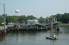
The Old Bridge has been moved and is now a museum and gift shop, sitting almost directly under the new Mannon C. Gore bridge.

Preceded by Beaches of Southeastern North Carolina Succeeded by
Southernmost point