Ocean Isle Beach, North Carolina

Last updated

Ocean Isle Beach, North Carolina
Ocean Isle Beach NC Fishing Pier Jun 10.JPG
Ocean Isle Beach Fishing Pier
Ocean Isle Beach, NC Town Seal.png
Motto: 
"Unchanged"
USA North Carolina relief location map.jpg
Red pog.svg
Ocean Isle Beach
Location within the state of North Carolina
Coordinates: 33°53′35″N78°25′53″W / 33.89306°N 78.43139°W / 33.89306; -78.43139
CountryUnited States
State North Carolina
County Brunswick
TownshipShallotte Township
Area
[1]
  Total4.72 sq mi (12.22 km2)
  Land3.74 sq mi (9.69 km2)
  Water0.98 sq mi (2.53 km2)
Elevation
[2]
0 ft (0 m)
Population
 (2020)
  Total867
  Density231.69/sq mi (89.47/km2)
Time zone UTC-5 (Eastern (EST))
  Summer (DST) UTC-4 (EDT)
ZIP code
28469
Area codes 910, 472
FIPS code 37-48700 [3]
GNIS feature ID2407032 [2]
Website www.oibgov.com

Ocean Isle Beach (or simply Ocean Isle) is a small seaside town in Brunswick County, North Carolina, United States. It was incorporated as a town in 1959 [4] and is part of the Wilmington, NC Metropolitan Statistical Area. The population was 867 at the 2020 census. Located at the southern end of North Carolina's Atlantic coastline, along the Atlantic Intracoastal Waterway, Ocean Isle Beach has private homes, seasonal rentals, and tourist attractions.

Contents

History

Ocean Isle Beach completed a roundabout located at North Carolina Highway 179. This design includes a brick retaining wall with "Welcome to Ocean Isle Beach" along with three bronze statues of children playing with kites. [5]

The American Shore and Beach Preservation Association named Ocean Isle Beach the winner of its 2008 Best Restored Beach Award. Ocean Isle Beach's quest for a federal beach restoration program began after Hurricane Hugo devastated the area in 1989. The town lobbied members of Congress for federal funding and opened a capital reserve savings account to provide the local share of funding necessary for restoration. Coastal engineers began the project in 2001 and provided high-quality sand for the beach and created a deeper channel for boaters. Judging for the award was based on three criteria: the economic and ecological benefits the beach brings to its community; the short and long-term success of the restoration project; and the challenges each community overcame during the course of the project. [6]

Geography

View of the Atlantic Ocean from Ocean Isle Beach Ocean isle Beach.jpg
View of the Atlantic Ocean from Ocean Isle Beach

Ocean Isle Beach is located in southwest Brunswick County. The town spans the barrier island of Ocean Isle Beach, extending 5 miles (8 km) from Tubbs Inlet on the west to Shallotte Inlet on the east, and a section of the mainland to the north along North Carolina Highway 904.

According to the United States Census Bureau, the town has a total area of 4.5 square miles (11.7 km2); 3.4 square miles (8.8 km2) is land (74.79%) and the balance water. [7]

The quiet sound in Western Ocean Isle during low tide, taken by a panoramic camera view. West Ocean Isle.jpg
The quiet sound in Western Ocean Isle during low tide, taken by a panoramic camera view.

Weather

Weather in Ocean Isle tends to be warm but varied, with the temperature averaging around 88F (31C) during the Summer of 2021, and 58F (14C) during the Winter of 2020. Rainfall is normal during the end of the Summer, and lightning storms are frequent. Hurricanes are also common and have been known to cause fires. In 1989, Hurricane Hugo devastated the area. In 2020, Hurricane Isaias made landfall near Ocean Isle Beach, as high end Category 1, causing significant damage to waterfront properties and the fishing pier.

Demographics

Historical population
CensusPop.Note
1960 5
1970 781,460.0%
1980 14383.3%
1990 523265.7%
2000 426−18.5%
2010 55029.1%
2020 86757.6%
U.S. Decennial Census [8] [7]
Ocean Isle Pier Ocean Isle Beach.jpg
Ocean Isle Pier

2020 census

Ocean Isle Beach racial composition [9]
RaceNumberPercentage
White (non-Hispanic)82294.81%
Native American 30.35%
Asian 60.69%
Pacific Islander 10.12%
Other/Mixed 202.31%
Hispanic or Latino 151.73%

As of the 2020 United States census, there were 867 people, 374 households, and 289 families residing in the town.

2000 census

As of the census [3] of 2000, there were 426 people, 209 households, and 141 families residing in the town. The population density was 124.2 inhabitants per square mile (48.0/km2). There were 2,507 housing units at an average density of 731.0 per square mile (282.2/km2). The racial makeup of the town was 98.59% White, 0.94% Native American and 0.47% Asian. Hispanic or Latino of any race were 0.47% of the population.

There were 209 households, out of which 11.5% had children under the age of 18 living with them, 62.7% were married couples living together, 2.4% had a female householder with no husband present, and 32.5% were non-families. 25.4% of all households were made up of individuals, and 5.3% had someone living alone who was 65 years of age or older. The average household size was 2.04 and the average family size was 2.40.

In the town, the population was spread out, with 10.3% under the age of 18, 5.4% from 18 to 24, 17.8% from 25 to 44, 45.3% from 45 to 64, and 21.1% who were 65 years of age or older. The median age was 53 years. For every 100 females, there were 99.1 males. For every 100 females age 18 and over, there were 97.9 males.

The median income for a household in the town was $67,639, and the median income for a family was $65,625. Males had a median income of $37,188 versus $22,188 for females. The per capita income for the town was $42,605. About 3.5% of families and 4.1% of the population were below the poverty line, including none of those under age 18 and 5.9% of those age 65 or over.

Arts and culture

Known as the "Gem of the Brunswick Islands", [10] Ocean Isle Beach is located along the coastal corridor between Wilmington, North Carolina and Myrtle Beach, South Carolina. The beach runs east to west and offers a fishing pier, public boat launch facility, direct access to the Intracoastal Waterway, and beach paths every 500 feet (150 m).[ citation needed ] The Museum of Coastal Carolina offers dioramas on coastal life, a touch tank, a collection of Civil War and Native American artifacts, and a variety of interactive exhibits.[ citation needed ]

A popular myth in Ocean Isle beach are the mysterious lights which float over the ocean during the nighttime. It is unknown whether it is a drone, stars, or fishing boats. It has been reported to split apart into multiple lights before joining back together.[ citation needed ]

One of the eastern streets of Ocean Isle was, at one point, flooded and is now engulfed underwater. Pieces of the remaining asphalt from the street have washed up on the beaches. To defend against future flooding, sandbags have been installed under the stilted houses on "second street" and the beaches have been manually expanded. As of 2022, the beaches on the east side of the island have been heavily cleaned and restored.[ citation needed ]

Parks and recreation

Brunswick County has completed a new 58-acre (23 ha) recreational park on the mainland. The park offers a variety of amenities, such as an amphitheater, festival grounds, ball parks, lighted tennis courts, and biking trails. This recreational park is located on Old Georgetown Road and is part of a $500,000 federal grant for parks throughout the county. Other projects scheduled is the Shallotte Blvd Recreation Area, which is a joint project between Ocean Isle Beach Land Conservancy and the Town of Ocean Isle Beach. The park will be at Shallotte Blvd and the ferry landing at the East end of the island. The recreation area will have a gazebo, picnic tables, a fishing pier, and a walkway with steps to the sand.

On the island of Ocean Isle Beach the town has recently finished a community area with an amphitheater, playground, small water area and bathrooms. Likewise. a children's play area and public gazebo are located on the eastern end of the island adjacent to the Intracoastal Waterway, along with a concert stage. The Town of Ocean Isle is also about to finish a new town Hall with administration office next to the Fire station.

Related Research Articles

<span class="mw-page-title-main">Georgetown County, South Carolina</span> County in South Carolina, United States

Georgetown County is a county located in the U.S. state of South Carolina. As of the 2020 census, the population was 63,404. Its county seat is Georgetown. The county was founded in 1769. It is named for George III of the United Kingdom.

<span class="mw-page-title-main">Dare County, North Carolina</span> County in North Carolina, United States

Dare County is the easternmost county in the U.S. state of North Carolina. As of the 2020 census, the population was 36,915. Its county seat is Manteo.
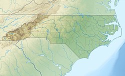
<span class="mw-page-title-main">Brunswick County, North Carolina</span> County in North Carolina, United States

Brunswick County is the southernmost county in the U.S. state of North Carolina. As of the 2020 census, the population was 136,693. Its population was only 73,143 in 2000, making it one of the fastest-growing counties in the state. With a nominal growth rate of approximately 47% in ten years, much of the growth is centered in the eastern section of the county in the suburbs of Wilmington such as Leland, Belville and Southport. The county seat is Bolivia, which at a population of around 150 people is among the least populous county seats in the state.

<span class="mw-page-title-main">Flagler Beach, Florida</span> City in Florida, United States

Flagler Beach is a city in Flagler County in the U.S. state of Florida. The population was 5,160 at the 2020 census.

<span class="mw-page-title-main">Golden Beach, Florida</span> Town in Florida

Golden Beach is a town in Miami-Dade County, Florida, United States, between the Intracoastal Waterway and Atlantic Ocean. The town is part of the Miami metropolitan area of South Florida. As of the 2020 US census, the town had a population of 961.

<span class="mw-page-title-main">Sunny Isles Beach, Florida</span> City in Florida

Sunny Isles Beach is a city located on a barrier island in northeast Miami-Dade County, Florida, United States. The city is part of the Miami metropolitan area of South Florida, and is bounded by the Atlantic Ocean on the east and the Intracoastal Waterway on the west. As of the 2020 census, it had a population of 22,342.

Calabash is a small fishing town in Brunswick County, North Carolina, United States. As of the 2020 census, the population of the town was 2,011. It is known as the "Seafood Capital of the World" because of the town's seafood restaurants.

<span class="mw-page-title-main">Caswell Beach, North Carolina</span> Town in North Carolina, United States

Caswell Beach is a small seaside town located on the Atlantic Ocean at the mouth of the Cape Fear River in Southeastern North Carolina, United States. Occupying the eastern part of Oak Island in Brunswick County, its population was listed at 395 in the 2020 census. Prominent features include the Civil War era Fort Caswell, the Oak Island Lighthouse co-located with the Oak Island Coast Guard Station, and the Oak Island Golf Club, the sole business in town and one of the few eighteen-hole courses located on a North Carolina barrier island. Along with the Town of Oak Island which occupies the central and west parts of the island, Caswell Beach is part of the Wilmington, NC Metropolitan Statistical Area.

<span class="mw-page-title-main">Holden Beach, North Carolina</span> Seaside town in North Carolina, United States

Holden Beach is a seaside town in Brunswick County, North Carolina. The population was 575 at the time of the 2010 census. It is part of the Wilmington, NC Metropolitan Statistical Area.

<span class="mw-page-title-main">Oak Island, North Carolina</span> Town in North Carolina, United States

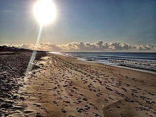
Oak Island is a seaside town located in the southeastern corner of North Carolina, United States. Part of Brunswick County, the major portion of the town is on Oak Island which it shares with Caswell Beach. Founded in 1999 as the result of the consolidation of two existing towns, Oak Island's main industry is tourism. Per the 2020 census, the town has a permanent population of 8,396 while its summer population is near 50,000. It along with the town of Caswell Beach is part of the Wilmington, NC, Metropolitan Statistical Area.

<span class="mw-page-title-main">Shallotte, North Carolina</span> Town in North Carolina, United States

Shallotte is a town in Brunswick County, North Carolina, United States. The population was 3,675 at the 2010 census. The Shallotte River passes through the town.

<span class="mw-page-title-main">Sunset Beach, North Carolina</span> Town in North Carolina, United States

Sunset Beach is a seaside town in Brunswick County, North Carolina, United States. The population was 3,572 at the 2010 census, up from 1,824 in 2000 census. It is part of the Wilmington, NC Metropolitan Statistical Area.

<span class="mw-page-title-main">Emerald Isle, North Carolina</span> Town in North Carolina, United States

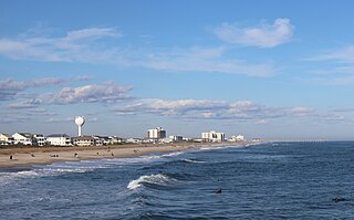
Emerald Isle is a town in Carteret County, North Carolina, United States. It is part of the Crystal Coast and is located entirely on Bogue Banks. The population was 3,847 at the 2020 census, but as many as 50,000 tourists each week inhabit the area during the summer season, filling up vacant rental properties that do not count toward official census results.

<span class="mw-page-title-main">Nags Head, North Carolina</span> Town in North Carolina, United States

Nags Head is a town in Dare County, North Carolina, United States. It is a busy vacation spot because of its beaches and sand dunes of Jockey's Ridge. The population was 3,146 at the 2020 census.

<span class="mw-page-title-main">Wrightsville Beach, North Carolina</span> Town in North Carolina, United States

Wrightsville Beach is a town in New Hanover County, North Carolina, United States. Wrightsville Beach is just east of Wilmington and is part of the Wilmington Metropolitan Statistical Area. The population was 2,477 at the 2010 census. The town consists of a 4-mile (6 km) long beach island, an interior island called Harbor Island, and pockets of commercial property on the mainland. It served as a filming location of Dawson's Creek.

<span class="mw-page-title-main">Swansboro, North Carolina</span> Town in North Carolina, United States

Swansboro is a town in Onslow County, North Carolina, United States, located along the Atlantic Ocean. In 2010, the population was 2,663. By 2021, the population had grown to 3,825.

<span class="mw-page-title-main">Isle of Palms, South Carolina</span> Barrier island on the coast of South Carolina, United States

Isle of Palms is a city in Charleston County, South Carolina, United States. At the 2010 census, the population was 4,133. Isle of Palms is a barrier island on the South Carolina coast. The city is included within the Charleston-North Charleston-Summerville metropolitan area and the Charleston-North Charleston Urbanized Area. The town lies along a narrow strip of land, hugging the beach, separated from the mainland by the Intracoastal Waterway. It is a community of both vacation home owners and year-round residents, with large beachfront homes, resorts, and local restaurants. Beach volleyball is popular in the summer, and the "Windjammer" club hosts several tournaments throughout the year.

<span class="mw-page-title-main">McClellanville, South Carolina</span> Town in South Carolina, United States

McClellanville is a small fishing town in rural Charleston County, South Carolina, United States. The population was 605 at the 2020 census. It is situated on the Atlantic coast, on land surrounded by Francis Marion National Forest, and has traditionally derived its livelihood from the Atlantic Ocean and coastal marshes by fishing, shrimping and oystering. McClellanville is part of the Charleston-North Charleston-Summerville metropolitan area and the Charleston-North Charleston Urbanized Area.

<span class="mw-page-title-main">Surf City, North Carolina</span> Town in North Carolina, United States

Surf City is a town in Onslow and Pender counties in the U.S. state of North Carolina. The population was 3,867 at the 2020 census. It is located on Topsail Island.

<span class="mw-page-title-main">Cape Fear (region)</span> Wilmington metropolitan area

Cape Fear is a coastal plain and Tidewater region of North Carolina centered about the city of Wilmington. The region takes its name from the adjacent Cape Fear headland, as does the Cape Fear River which flows through the region and empties into the Atlantic Ocean near the cape. Much of the region's populated areas are found along the Atlantic beaches and the Atlantic Intracoastal Waterway, while the rural areas are dominated by farms and swampland like that of the Green Swamp. The general area can be also identified by the titles "Lower Cape Fear", "Wilmington, NC Metropolitan Statistical Area", "Southeastern North Carolina", and "Azalea Coast". The latter name is derived from the North Carolina Azalea Festival held annually in Wilmington. Municipalities in the area belong to the Cape Fear Council of Governments.

References

  1. "ArcGIS REST Services Directory". United States Census Bureau. Retrieved September 20, 2022.
  2. 1 2 U.S. Geological Survey Geographic Names Information System: Ocean Isle Beach, North Carolina
  3. 1 2 "U.S. Census website". United States Census Bureau . Retrieved January 31, 2008.
  4. "Ocean Isle Beach". Star-News. May 24, 1998. p. 37. Retrieved November 1, 2015.
  5. "Construction Coming for OIB". oceanislebeach. January 8, 2020.
  6. "Ocean Isle Beach, North Carolina - Official Website".
  7. 1 2 "Geographic Identifiers: 2010 Demographic Profile Data (G001): Ocean Isle Beach town, North Carolina". U.S. Census Bureau, American Factfinder. Archived from the original on February 12, 2020. Retrieved February 12, 2014.
  8. "Census of Population and Housing". Census.gov. Retrieved June 4, 2015.
  9. "Explore Census Data". data.census.gov. Retrieved December 22, 2021.
  10. "Ocean Isle Beach, Gem of the Brunswick Islands". Coastal Communities. The Coastal Companies. March 31, 2011. Retrieved February 25, 2020.

Commons-logo.svg Media related to Ocean Isle Beach, North Carolina at Wikimedia Commons

Preceded by Beaches of Southeastern North Carolina Succeeded by