
The Michipicoten River is a river in Algoma District of northern Ontario, Canada, which flows from Dog Lake and joins with the Magpie River to empty into Michipicoten Bay on Lake Superior near the town of Wawa. This river is 113 km (70 mi) in length and drains an area of about 5,200 km2 (2,000 sq mi).

A branch line is a secondary railway line which branches off a more important through route, usually a main line. A very short branch line may be called a spur line.

The Spanish River is a river in Algoma District, Sudbury District and Greater Sudbury in Northeastern Ontario, Canada. It flows 338 kilometres (210 mi) in a southerly direction from its headwaters at Spanish Lake and Duke Lake to its mouth at the North Channel of Lake Huron just outside the community of Spanish.

The Algoma Central Railway is a railway in Northern Ontario that operates between Sault Ste. Marie and Hearst. It used to have a branch line to Wawa, Ontario. The area served by the railway is sparsely populated, with few roads.
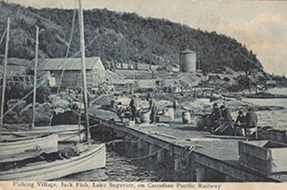
Jackfish is a ghost town in northern Ontario, Canada, located on the north shore of Lake Superior east of Terrace Bay.
The Magpie River is a river in Algoma District, northeastern Ontario, Canada, The river empties into Michipicoten Bay on Lake Superior near the town of Wawa. The river drains an area of about 1,900 square kilometres (734 sq mi).

Unorganized North Algoma District is an unorganized area in northeastern Ontario, Canada, comprising all areas in Algoma District, north of the Sault Ste. Marie to Elliot Lake corridor, which are not part of an incorporated municipality or a First Nation. It covers 44,077.03 km2 (17,018.24 sq mi) of land, and had a population of 5739 in 2016.

The Huron Central Railway is a railway operating in northern Ontario, Canada. It is operated by Genesee & Wyoming Canada, the Canadian subsidiary of Genesee & Wyoming.

Baldwin is a township in the Canadian province of Ontario. Located in Sudbury District north of Espanola, the township's two main communities and population centres are McKerrow and Lorne.

The Sudbury–White River train, formerly the Lake Superior, informally called the Budd Car, is a Canadian passenger train operated by Via Rail serving communities between Sudbury and White River, Ontario three times a week. The timetable numbers for this train are 185 for the westbound and 186 for the eastbound.
Esnagi Lake is a large "V"-shaped lake in the Unorganized North part of Algoma District, Ontario, Canada. Part of the Great Lakes Basin, it is about 45 kilometres (28 mi) long and 5.0 kilometres (3.1 mi) wide and lies at an elevation of 344 metres (1,129 ft), with the "V" on its side and the apex facing west. The primary inflows are the Magpie River from Mosambik Lake at the north end of the lake, Tripoli Creek on the west side, and other unnamed creeks. The primary outflow is also the Magpie River, which flows downstream from the south end of the lake at the east switch of the siding at Swanson on the Canadian Pacific Railway transcontinental mainline, and eventually into Lake Superior.

Wabatongushi Lake is a lake in Northern Ontario, Canada, fully within the Chapleau Crown Game Preserve. The lake is highly diversified in its topography. The north end of Wabatongushi is shallow with many low, swampy areas. This is perfect habitat for northern pike and hungry moose. The south half of the lake is much deeper, with a maximum depth of 175' located right off of Loch Island Lodge. This set up is ideal for large game fish such as walleye and northern pike. The shoreline on the south end is much higher, with exposed Pre-Cambrian shield plummeting straight into the tea-stained water. Large schools of bait fish congregate off of these shorelines which attract the game fish. Fishing is excellent in these locations on the south end near Loch Island Lodge. Wabatongushi is the top lake in a chain that stretches almost 100 miles, eventually draining into lake Superior. It sits on the crest of the northern watershed. Wabatongushi Lake was a traditional transportation route from Hudson Bay to Lake Superior for both First Nations and Voyageurs. Wabatongushi in the Ojibwa language approximately means "White Sand Lake".
Tripoli Creek is a creek in the Unorganized North Part of Algoma District in northeastern Ontario, Canada. It is part of the Lake Superior drainage basin.
Mosambik Lake is a lake in the Lake Superior drainage basin in Algoma District, Ontario, Canada. It is about 5.9 kilometres (3.7 mi) long and 2.0 kilometres (1.2 mi) wide and lies at an elevation of 347 metres (1,138 ft). The primary inflow is the Magpie River from North Wejinabikun Lake on the west side of the lake, and there are several unnamed creek inflows, including one from Kabiskagami Lake on the southwest side. The primary outflow is also the Magpie River, which flows downstream from the north end of the lake towards Esnagi Lake, and eventually into Lake Superior.
Summit Lake is a lake in the James Bay drainage basin in the Unorganized North Part of Algoma District in northeastern Ontario, Canada. It is the source of the Kabinakagami River, which flows via the Kenogami River and Albany River to James Bay. The lake is about 1.0 kilometre (0.6 mi) long and 0.2 kilometres (0.1 mi) wide, lies at an elevation of 442 metres (1,450 ft), and there are no significant inflows.
The Vermilion River is a river in the Lake Huron drainage basin in Sudbury District and Greater Sudbury in Northeastern Ontario, Canada.

Ryerson is a railway point and unincorporated place in the Unorganized North Part of Algoma District in northeastern Ontario, Canada. It lies on the Canadian Pacific Railway transcontinental main line between the settlements of Girdwood on the line 4 kilometres (2 mi) to the southwest and Swanson on the line 13.4 kilometres (8.3 mi) to the east. As of 2016, its population is 648, and 93.4% of the population's mother tongue is English. There is a siding at Ryerson, and Via Rail provides flag stop services with the Sudbury – White River train once daily in each direction. The place is adjacent to the eponymous Ryerson Creek and Ryerson Lake.
Girdwood is a railway point and unincorporated place in geographic Atkinson Township in the Unorganized North Part of Algoma District in northeastern Ontario, Canada. It lies on the Canadian Pacific Railway transcontinental main line between the settlements of Amyot on the line 13.5 kilometres (8.4 mi) to the west northwest and Ryerson on the line 4 kilometres (2 mi) to the northeast. Via Rail provides services to Girdwood railway station with the Sudbury – White River train once daily in each direction. Girdwood is adjacent to Tripoli Creek, a tributary of the Magpie River.
The Algoma Eastern Railway was a railway in Northeastern Ontario, Canada. Originally known as the Manitoulin and North Shore Railway (M&NS) with a charter dating back to 1888, the full mainline was opened to traffic in 1913, serving the area along the north shore of Lake Huron between Sudbury and Little Current on Manitoulin Island. It and its sister railway, the Algoma Central, were originally owned by the Lake Superior Corporation, a conglomerate centred on Sault Ste. Marie which was founded by the American industrialist Francis Clergue. Despite ambitious plans to expand across Lake Huron to the Bruce Peninsula using a railcar ferry, the company failed to develop further and was acquired by the Canadian Pacific Railway in 1930. With freight traffic low during the Great Depression, Canadian Pacific soon abandoned much of the Algoma Eastern mainline in favour of its own Algoma Branch. Remaining sections of the Algoma Eastern line were turned into spurs, with the longest surviving section operated as a branch line known as the Little Current Subdivision.

Redgrave siding is about 35 kilometres (22 mi) west of Golden, and about 40 kilometres (25 mi) east of the mid-point of the Connaught Tunnel beneath Rogers Pass, in southeastern British Columbia. Accessible by road in the summer months, the former small railway community is long gone. The highway turnoff is at the Redgrave Rest Area.

