
Restoule is a community and designated place in geographic Patterson Township in the Centre Unorganized Part of Parry Sound District in Central Ontario, Canada. It is situated on the Restoule River between Commanda Lake, and Restoule Lake and is part of the Almaguin Highlands region.

Lac-Sainte-Thérèse is a dispersed rural community in geographic Casgrain Township, Cochrane District in Northeastern Ontario, Canada. The community is counted as part of Unorganized Cochrane North Part in Canadian census data.

Jogues is a dispersed rural community and unincorporated place in geographic Way Township, Cochrane District in Northeastern Ontario, Canada. It is about 11 kilometres (6.8 mi) southwest of Hearst. Jogues is also a designated place served by a local services board.

Coppell is a dispersed rural community and unincorporated place in geographic Lowther Township, Cochrane District in Northeastern Ontario, Canada. It is about 22 kilometres (14 mi) southwest of Hearst, and is counted as part of Unorganized Cochrane North Part in Canadian census data.
Mead is a Dispersed Rural Community and unincorporated place in geographic Lowther Township, Cochrane District in Northeastern Ontario, Canada. The community is counted as part of Unorganized Cochrane North Part in Canadian census data, and is located just north of the border with Algoma District.

Batchawana Bay is an unincorporated place and Compact Rural Community in Algoma District in Northeastern Ontario, Canada. It is also the name of a local services board, consisting of parts of the geographic townships of Fisher, Herrick, Ryan and Tilley. It is located north of Sault Ste. Marie, Ontario, on the shores of Batchawana Bay off Lake Superior.

The Kapuskasing River is a river in the James Bay drainage basin in Cochrane District and Algoma District in northeastern Ontario, Canada. The river is a left tributary of the Mattagami River.
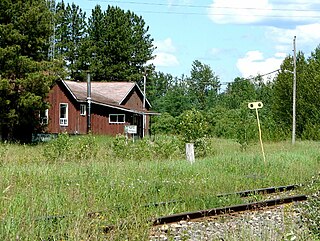
Horsey is a railway point and unincorporated place in geographic Templeton Township, Algoma District in Northeastern Ontario, Canada. The community is counted as part of Unorganized Algoma North Part in Canadian census data, and is located just south of the border with Cochrane District.
Boon is a railway point and unincorporated place in geographic Templeton Township, Algoma District in Northeastern Ontario, Canada. It is counted as part of Unorganized Algoma North Part in Canadian census data.
Hale is a Railway point and unincorporated place in geographic Templeton Township, Algoma District in Northeastern Ontario, Canada. The community is counted as part of Unorganized Algoma North Part in Canadian census data.
Elsas is an unincorporated place and railway point in geographic Kapuskasing Township, in the Unorganized North part of Algoma District in northeastern Ontario, Canada. It is on the Canadian National Railway transcontinental railway main line between the railway points of Agate to the west and Oatland to the east, and is the location of Elsas railway station, a stop for Via Rail transcontinental Canadian trains. The station and settlement are on the northern shore of Kapuskasing Lake, the source of the Kapuskasing River.
Kapuskasing Lake is a lake in Algoma District and Sudbury District in northeastern Ontario, Canada. It is in the James Bay drainage basin and is the source of the Kapuskasing River. The majority of the lake is in geographic Kapuskasing Township, Algoma District, with just the southern tip in geographic Sherlock Township, Sudbury District.
The Chapleau River is a river in Algoma District and Sudbury District in northeastern Ontario, Canada. It is in the James Bay drainage basin, begins at Chapleau Lake and is the main tributary of Kapuskasing Lake.
Agate is an unincorporated place and railway point in geographic Kapuskasing Township, in the Unorganized North part of Algoma District in northeastern Ontario, Canada. It is on the Canadian National Railway transcontinental railway main line between the railway points of Dunrankin to the west and Elsas to the east, has a passing track, and is passed but not served by Via Rail transcontinental Canadian trains. The place is just northwest of Kapuskasing Lake, the source of the Kapuskasing River.
Dunrankin is an unincorporated place and railway point in geographic Kirkwall Township, in the Unorganized North part of Algoma District in northeastern Ontario, Canada. It is on the Canadian National Railway transcontinental railway main line between the dispersed rural community of Peterbell to the west and the railway point of Agate to the east, and is passed but not served by Via Rail transcontinental Canadian trains. The place is on the Dunrankin River, a left tributary of the Kapuskasing River.
Peterbell is an unincorporated place and dispersed rural community in geographic Coderre Township, in the Unorganized North part of Algoma District in northeastern Ontario, Canada. It is on the Canadian National Railway transcontinental railway main line between the railway points of Argolis to the west and Dunrankin to the east, has a passing track, and is passed but not served by Via Rail transcontinental Canadian trains. The place is on the Missinaibi River, a tributary of the Moose River. It is named for Peter Bell, who was in charge of the Hudson's Bay Company Superior District from 1866 to 1895.
The Dunrankin River is a river in Algoma District and Sudbury District in northeastern Ontario, Canada. It is in the James Bay drainage basin, begins at Upper Dunrankin Lake and is a left tributary of the Kapuskasing River.
The East Dunrankin River is a river in Algoma District and Sudbury District in northeastern Ontario, Canada. It is in the James Bay drainage basin, and is a right tributary of the Dunrankin River.
The Kirkwall River is a river in Algoma District and Sudbury District in northeastern Ontario, Canada. It is in the James Bay drainage basin, and is a right tributary of the Dunrankin River.
The Nemegosenda River is a river in Algoma District and Sudbury District in northeastern Ontario, Canada. It is in the James Bay drainage basin, and is a right tributary of the Kapuskasing River.

