
Sulawesi, also known as Celebes, is an island in Indonesia. One of the four Greater Sunda Islands, and the world's eleventh-largest island, it is situated east of Borneo, west of the Maluku Islands, and south of Mindanao and the Sulu Archipelago. Within Indonesia, only Sumatra, Borneo, and Papua are larger in territory, and only Java and Sumatra have larger populations.
A marine park is a designated park consisting of an area of sea set aside to achieve ecological sustainability, promote marine awareness and understanding, enable marine recreational activities, and provide benefits for Indigenous peoples and coastal communities. Most marine parks are managed by national governments, and organized like 'watery' national parks, whereas marine protected areas and marine reserves are often managed by a subnational entity or non-governmental organization, such as a conservation authority.
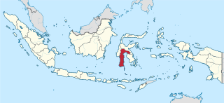
South Sulawesi is a province in the southern peninsula of Sulawesi. The Selayar Islands archipelago to the south of Sulawesi is also part of the province. The capital is Makassar. The province is bordered by Central Sulawesi and West Sulawesi to the north, the Gulf of Bone and Southeast Sulawesi to the east, Makassar Strait to the west, and Flores Sea to the south.

Alas Purwo National Park is situated on Blambangan Peninsula in the Banyuwangi Regency, at the southeastern tip of East Java province. The park is famous for its wild Banteng and surfing location at Grajagan Bay.

Komodo National Park is a national park in Indonesia located within the Lesser Sunda Islands in the border region between the provinces of East Nusa Tenggara and West Nusa Tenggara. The park includes the three larger islands Komodo, Padar and Rinca, and 26 smaller ones, with a total area of 1,733 km2. The national park was founded in 1980 to protect the Komodo dragon, the world's largest lizard. Later it was dedicated to protecting other species, including marine species. In 1991 the national park was declared a UNESCO World Heritage Site.

Baa Atoll is an administrative division of the Maldives. It consists of three separate natural atolls, namely southern Maalhosmadulu Atoll, the Fasdūtherē Atoll and the smaller natural atoll known as Goifulhafehendhu Atoll.

The Tubbataha Natural Park, also known as the Tubbataha Reefs Natural Park, is a protected area of the Philippines located in the middle of the Sulu Sea. The marine and bird sanctuary consists of two huge atolls and the smaller Jessie Beazley Reef covering a total area of 97,030 hectares. It is located 150 kilometres (93 mi) southeast of Puerto Princesa, the capital of Palawan. The uninhabited islands and reefs are part of the island municipality of Cagayancillo, located roughly 130 kilometers (81 mi) to the northeast of the reef.
Selayar or Saleyer, is an archipelago of South Sulawesi province, Indonesia. It lies in the Flores Sea, between Sulawesi and Flores, around 150 km southeast of the major city of Makassar. Kabupaten Selayar is the Regency, covering 1,357 km² with a population of about 138,000 (2021). There are 73 islands, the main one being Selayar Island. To the east lies Pulau (Island) Kalaotoa and Pulau Karompa Lompo, and to the west lies Kepulauan Sabalana. It is a biodiverse diving site.

Wakatobi Regency is a group of ca. 150 islands forming an administrative regency located in Southeast Sulawesi, Indonesia. The four largest islands are Wangi-wangi, Kaledupa, Binongko and Tomia. The capital of the regency is located on Wangi-wangi Island, and was established by virtue of Law of the Republic of Indonesia Number 29 of 2003 dated 18 December 2003. The regency has an area of 473.62 square kilometres and had a population of 92,922 at the 2010 Census and 111,402 at the 2020 Census; the official estimate as at mid 2021 was 113,122.
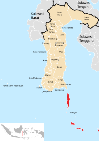
The Selayar Islands Regency is a regency of Indonesia in South Sulawesi province that covers the Selayar Islands, which lie to the south of Sulawesi. The regency covers an area of 1,357.03 km2, and had a population of 103,596 at the 2000 Census, 122,055 at the Census of 2010 and 137,071 at that of 2020. The official estimate for mid 2021 was 137,974. The Selayar Straits separate the regency from Sulawesi island.

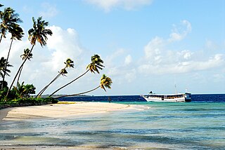
The Taka Bonerate Islands in Indonesia consist of 28 atoll islands, together with the larger island of Kayuadi lying west of the atoll. They lie about 3 to 4 hours by boat from Benteng, the administrative capital of the Selayar Islands. Together they make up the Takabonerate District of Selayar Regency in South Sulawesi Province. It is part of a National Marine Park, with dive sites, pelagic fishes, dolphins, turtles, many soft corals, sea fans. Also it is the third largest atoll in the world.

Moyo is an island in Indonesia's West Nusa Tenggara province. It is off the north coast of Sumbawa Island, and has an area of 349 km2. Moyo Island is located in Sumbawa Regency within the Nusa Tenggara province, just north of Sumbawa. The island has an area of 32,044 hectares, about 8° south of the equator. The island is proposed as part of Moyo Satonda National Park along with Satonda Island.

Loggerhead Key is an uninhabited tropical island within the Dry Tortugas group of islands in the Gulf of Mexico. At approximately 49 acres in size, it is the largest island of the Dry Tortugas. Despite being uninhabited, the island receives visitors, such as day visitors and campers. The island only has a few built structures, including the Dry Tortugas Light and a lightkeeper's house that was constructed in the 1920s. The island has drinking water derived using desalination technology and solar power. The Carnegie Marine Biological Laboratory operated on Loggerhead Key from 1904 to 1939.

Bunaken National Park is a marine park in the north of Sulawesi island, Indonesia. The park is located near the centre of the Coral Triangle, providing habitat to 390 species of coral as well as many fish, mollusc, reptile and marine mammal species. The park is representative of Indonesian tropical water ecosystems, consisting of seagrass plain, coral reef, and coastal ecosystems.

Karimunjawa National Park, also Crimon Java National Park, is a national marine park designated in the Karimun Java archipelago, Jepara Regency, Central Java, Indonesia. It lies 80 km north west of Jepara, Central Java in the Java Sea. The national park was formally declared as Marine Protection Area in 2001. Based on popular local myth, this archipelago was discovered by Sunan Nyamplungan, the nephew of Sunan Kudus who is one of the Wali Sanga.

Teluk Cenderawasih National Park is the largest marine national park of Indonesia, located in Cenderawasih Bay, south-east of Bird's Head Peninsula. It includes the islands of Mioswaar, Nusrowi Island, Roon, Rumberpon, Anggrameos and Yoop. The park protects a rich marine ecosystem, with over 150 recorded coral species, for which it is considered a potential World Heritage Site.
Wakatobi National Park is a marine national park in Southeast Sulawesi, Indonesia. The name of Wakatobi is a portmanteau of the four main Tukangbesi Islands: Wangi-wangi, Kaledupa, Tomia, and Binongko. Since 2005 the park is listed as a tentative World Heritage Site.
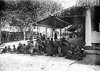
The Bonerate people are an ethnic group in South Sulawesi, Indonesia. They inhabit around the Selayar island group such as Bonerate, Madu, Kalaotoa, and Karompa islands.

The Thousand Islands are a chain of islands to the north of Jakarta's coast. It forms the only regency of Jakarta, the capital of Indonesia. It consists of a string of 342 islands stretching 45 km (28 mi) north into the Java Sea at West Jakarta Bay and in fact north of Banten Province. Pramuka Island is the regency seat.


