
Kyoto, officially Kyoto City, is the capital city of Kyoto Prefecture in Japan. Located in the Kansai region on the island of Honshu, Kyoto forms a part of the Keihanshin metropolitan area along with Osaka and Kobe. As of 2021, the city has a population of 1.45 million. The city is the cultural anchor of a substantially larger metropolitan area known as Greater Kyoto, a metropolitan statistical area (MSA) home to a census-estimated 3.8 million people.

Kamo is a city located in Niigata Prefecture, Japan. As of 1 July 2019, the city had an estimated population of 25,971 in 10,270 households, and a population density of 194 persons per km². The total area of the city was 133.72 square kilometres (51.63 sq mi).

Tsuyama is a city in Okayama Prefecture, Japan. As of 2017, the city had an estimated population of 102,294 and a population density of 200 persons per km². The total area was 185.73 km². The area increased in 2005 as the result of a merger with adjacent towns, which also boosted the city's population to more than 100,000.
The name Kamo may refer to the following:

The Kamo River is located in Kyoto Prefecture, Japan. The riverbanks are popular walking spots for residents and tourists. In summer, restaurants open balconies looking out to the river. There are walkways running alongside the river, and some stepping stones that cross the river. The water level of the river is usually relatively low; less than one meter in most places. During the rainy season, however, the walkways sometimes flood in their lower stretches.
Kamo Shrine is a general term for an important Shinto sanctuary complex on both banks of the Kamo River in northeast Kyoto. It is centered on two shrines. The two shrines, an upper and a lower, lie in a corner of the old capital which was known as the "devil's gate" due to traditional geomancy beliefs that the north-east corner brought misfortune. Because the Kamo River runs from the north-east direction into the city, the two shrines along the river were intended to prevent demons from entering the city.

Higashiyama is one of the eleven wards in the city of Kyoto, in Kyoto Prefecture, Japan.

Kamigyō-ku (上京区) is one of the eleven wards in the city of Kyoto, in Kyoto Prefecture, Japan. Located in the center of the present-day city of Kyoto, Japan it previously occupied the northern region of the ancient capital of Kyoto. The Kamo River flows on the eastern border of the ward. The area was previously a district of residences for the royalty and upper classes in the old capital.

Sakyō-ku is one of the eleven wards in the city of Kyoto, in Kyoto Prefecture, Japan. It is located in the northeastern part of the city.

Minami is one of the eleven wards in the city of Kyoto, in Kyoto Prefecture, Japan. Its name means "South Ward." It was established in 1955 when it was separated from Shimogyo-ku. As of April, 2016 the ward has an estimated population of 100,781 people. The Kamo River and the Katsura River flow through the district. It is home to several historical places and temples.

The Katsura River is a continuation of two other rivers, the Hozu River, a small, speedy river which begins in the mountains near Kameoka and then slithers through the mountains separating Kameoka and Kyoto; and the Ōi River, which emerges from those mountains and expands into a shallow, slow-flowing river until Togetsukyo Bridge in Arashiyama. From that point forward, the river is referred to as the Katsura River, and its flow continues for several kilometers through Kyoto Prefecture until it joins the Kamo and Uji rivers.

Hōjōki, variously translated as An Account of My Hut or The Ten Foot Square Hut, is an important and popular short work of the early Kamakura period (1185–1333) in Japan by Kamo no Chōmei. Written in March 1212, the work depicts the Buddhist concept of impermanence (mujō) through the description of various disasters such as earthquake, famine, whirlwind and conflagration that befall the people of the capital city Kyoto. The author Chōmei, who in his early career worked as court poet and was also an accomplished player of the biwa and koto, became a Buddhist monk in his fifties and moved farther and farther into the mountains, eventually living in a 10-foot square hut located at Mt. Hino. The work has been classified both as belonging to the zuihitsu genre and as Buddhist literature. Now considered as a Japanese literary classic, the work remains part of the Japanese school curriculum.

Shijō Kawaramachi (四条河原町) is a vibrant part of central Kyoto, Japan where Shijō and Kawaramachi Streets intersect. Kawaramachi Street runs parallel to the Kamo River on the eastern side of Kyoto, while Shijō Street runs east–west through the center of the city.

Shijō Street runs in the center of Kyoto, Japan from east to west through the commercial center of the city. Shijō literally means Fourth Avenue of Heian-kyō, the ancient capital.

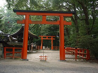
Kamigamo Shrine is an important Shinto sanctuary on the banks of the Kamo River in north Kyoto, first founded in 678. Its formal name is the Kamo-wakeikazuchi Shrine.
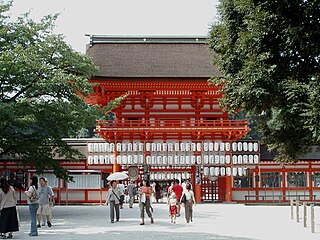
Shimogamo Shrine is an important Shinto sanctuary in the Shimogamo district of Kyoto city's Sakyō ward. Its formal name is Kamo-mioya-jinja (賀茂御祖神社). It is one of the oldest Shinto shrines in Japan and is one of the seventeen Historic Monuments of Ancient Kyoto which have been designated by UNESCO as a World Heritage Site. The term Kamo-jinja in Japanese is a general reference to Shimogamo Shrine and Kamigamo Shrine, the traditionally linked Kamo shrines of Kyoto; Shimogamo is the older of the pair, being believed to be 100 years older than Kamigamo, and dating to the 6th century, centuries before Kyoto became the capital of Japan. The Kamo-jinja serve the function of protecting Kyoto from malign influences.
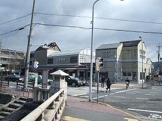
Demachiyanagi Station is a railway station located in Sakyō-ku, Kyoto, Kyoto Prefecture, Japan.

Kamo clan is a Japanese sacerdotal kin group which traces its roots from a Yayoi period shrine in the vicinity of northeastern Kyoto. The clan rose to prominence during the Asuka and Heian periods when the Kamo are identified with the 7th-century founding of the Kamo Shrine.

Tadasu no Mori (糺の森), which literally means "Forest of Correction", is a sacred grove associated with an important Shinto sanctuary complex known in Japanese as the Kamo-jinja, situated near the banks of the Kamo River just north of where the Takano River joins the Kamo River in northeast Kyoto city, Japan. The term Kamo-jinja in Japanese is a general reference to Shimogamo Shrine and Kamigamo Shrine, the traditionally linked Kamo shrines of Kyoto. The Kamo-jinja serve the function of protecting Kyoto from malign influences.
Imadegawa Street is a major street that crosses the city of Kyoto from east to west, running approximately 7 km from the gate of the Ginkaku-ji to the vicinity of the railway crossing west of the Tōjiin Ritsumeikan University Station.
