Tallapoosa /tæləˈpuːsə/ is a city in Haralson County, Georgia. The population was 3,170 at the 2010 census, [4] up from 2,789 at the 2000 census.
The Georgia General Assembly incorporated Tallapoosa as a town in 1860. [5] The community lends its name to the Tallapoosa River. [6]
The name "Tallapoosa" is derived from the Creek words "Talwa" (town) and "Puse" (grandmother).
The name first appearing on Georgia maps in the 19th century, notably around the 1820's, the name "Tallapoosee" was used to refer to the Tallapoosa River and surrounding regions.
The spelling reflects documentation and naming conventions of the time, prior to the more standardized spelling "Tallapoosa" that became common later.
The name shows respect, reverence and origin of the grandmother as the native Creek and nearby Cherokee practiced a matrilineal system of descent. Clan membership, inheritance, social structure and descent were traced through the mothers line and passed down through the maternal side.
The Tallapoosa branch of the Muskogee (Creek) tribe is one of the oldest groups in the Southeast.
The Grandmother was seen as a central figure in community life. They held a significant role in council meetings and were regarded as the bearers of wisdom, tradition and cultural knowledge having a key role in mediating disputes and conflicts preserving traditions and guiding future generations. They often led social and ceremonial events.
Tallapoosa was a location of tribal meetings held by the Creek Indians, its location being a central point of trade between the Creek territory located in the lower flatlands to the south and the northern Cherokee territory located in the upper Appalachian mountains.
A historic marker marks this meeting location in Tallapoosa titled "Seven Chestnuts" where Creek Indians held their council meetings under seven chestnut trees. Another nearby historical marker titled "Sandtown Trail" marks the location of the Sandtown Trail a route taken by Creek Indians which later became a stage coach route traveled by white settlers.
Tallapoosa was once referred to as "Opossum Snout" (circa 1891) a painting titled by artist Lyell E. Carr depicting the area
Today the town hosts an annual New Year's Eve Possum Drop, one of the largest New Year's Eve celebrations in Georgia. [7]
Tallapoosa is located in the western part of Haralson County in northwest Georgia. Its geographic coordinates are 33°45′N85°17′W / 33.750°N 85.283°W (33.7437, -85.2879). [8]
U.S. Route 78 and Georgia State Route 100 are the main highways through the city. U.S. 78 runs through the city from east to west as Atlanta Street, leading southeast 7 mi (11 km) to Waco and west 9 mi (14 km) to Fruithurst, Alabama. GA-100 runs north–south through the city concurrent with U.S. 78, leading north 21 mi (34 km) to Cedartown and south 16 mi (26 km) to Bowdon. Interstate 20 passes about 5 mi (8.0 km) south of the city center, with access from exit 5 (GA-100). I-20 leads east 58 mi (93 km) to Atlanta and west 99 mi (159 km) to Birmingham, Alabama.
According to the U.S. Census Bureau, the city has a total area of 10.0 square miles (26.0 km2), of which 0.03 square miles (0.07 km2), or 0.27%, are water. [4]
Census | Pop. | Note | %± |
---|---|---|---|
1880 | 52 | — | |
1890 | 1,699 | 3,167.3% | |
1900 | 2,128 | 25.3% | |
1910 | 2,117 | −0.5% | |
1920 | 2,719 | 28.4% | |
1930 | 2,417 | −11.1% | |
1940 | 2,338 | −3.3% | |
1950 | 2,826 | 20.9% | |
1960 | 2,744 | −2.9% | |
1970 | 2,896 | 5.5% | |
1980 | 2,647 | −8.6% | |
1990 | 2,805 | 6.0% | |
2000 | 2,789 | −0.6% | |
2010 | 3,170 | 13.7% | |
2020 | 3,227 | 1.8% | |
U.S. Decennial Census [9] |
Race | Num. | Perc. |
---|---|---|
White (non-Hispanic) | 2,895 | 89.71% |
Black or African American (non-Hispanic) | 159 | 4.93% |
Native American | 7 | 0.22% |
Asian | 18 | 0.56% |
Other/Mixed | 112 | 3.47% |
Hispanic or Latino | 36 | 1.12% |
As of the 2020 United States census, there were 3,227 people, 1,368 households, and 789 families residing in the city.
As of the 2000 census, [2] there were 2,789 people, 1,187 households, and 764 families residing in the city. The population density was 375.6 inhabitants per square mile (145.0/km2). There were 1,334 housing units at an average density of 179.7 units per square mile (69.4 units/km2). The racial makeup of the city was 91.18% White, 6.63% African American, 0.22% Native American, 0.90% Asian, 0.07% from other races, and 1.00% from two or more races. Hispanic or Latino of any race were 0.32% of the population.
There were 1,187 households, out of which 28.3% had children under the age of 18 living with them, 46.3% were married couples living together, 14.9% had a female householder with no husband present, and 35.6% were non-families. 32.3% of all households were made up of individuals, and 16.4% had someone living alone who was 65 years of age or older. The average household size was 2.34 and the average family size was 2.95.
In the city, the population was spread out, with 24.7% under the age of 18, 7.5% from 18 to 24, 26.2% from 25 to 44, 23.8% from 45 to 64, and 17.7% who were 65 years of age or older. The median age was 38 years. For every 100 females, there were 81.3 males. For every 100 females age 18 and over, there were 79.6 males.
The median income for a household in the city was $29,938, and the median income for a family was $37,401. Males had a median income of $34,102 versus $21,130 for females. The per capita income for the city was $15,302. About 12.8% of families and 19.4% of the population were below the poverty line, including 25.0% of those under age 18 and 26.9% of those age 65 or over.
Tallapoosa is mentioned in these works:
The 1933 pre-code movie Baby Face, starring Barbara Stanwyck.
The song I've Been Everywhere , a performance [11] of which was recorded by Johnny Cash in 1996.
The poem "Stars at Tallapoosa" by Wallace Stevens, published in his collection Harmonium (1923).
TLC filmed the New Year's special of their show Here Comes Honey Boo Boo at The Possum Drop in Tallapoosa. [12]
Randolph County is a county on the central eastern border of the U.S. state of Alabama. As of the 2020 census, the population was 21,967. Its county seat is Wedowee. Its name is in honor of John Randolph, a member of the United States Senate from Virginia. Randolph County was a prohibition or dry county until 2012, when the citizens of Randolph County voted to repeal prohibition.
Tallapoosa County is a county located in the east-central portion of the U.S. state of Alabama. As of the 2020 census, the population was 41,311. Its county seat is Dadeville. Its largest city is Alexander City.
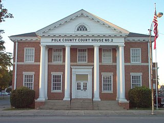
Polk County is a county in the Northwest region of the U.S. state of Georgia. As of the 2020 census, the population was 42,853. The county seat is Cedartown. The county was created on December 20, 1851, by an act of the Georgia General Assembly and named after James K. Polk, the eleventh President of the United States. Polk County comprises the Cedartown, GA Metropolitan Statistical Area.
Paulding County is a county in the Northwest region of the U.S. state of Georgia. Part of Metro Atlanta, it had an estimated population of 168,661 in 2020. The county seat is Dallas.
Murray County is a county in the Northwest region of the U.S. state of Georgia. As of the 2020 census, the population was 39,973. The county seat is Chatsworth. Murray County is part of the Dalton, GA Metropolitan Statistical Area, which is also included in the Chattanooga-Cleveland-Dalton, TN-GA-AL Combined Statistical Area.
Haralson County is a county in the Northwest region of the U.S. state of Georgia. As of the 2020 census, the population was 29,919, up from 28,780 in 2010. The county seat is Buchanan. The county was created on January 26, 1856, and was named for Hugh A. Haralson, a former Georgia congressman.
Floyd County is a county in the Northwest region of the U.S. state of Georgia. As of the 2020 United States Census, the population was 98,584. The county seat is Rome. Floyd County comprises the Rome, Georgia metropolitan statistical area.
Tallassee is a city on the Tallapoosa River, located in both Elmore and Tallapoosa counties in the U.S. state of Alabama. At the 2020 census, the population was 4,763. It is home to a major hydroelectric power plant at Thurlow Dam operated by Alabama Power Company.
Camp Hill is a town in Tallapoosa County, Alabama, United States. It was incorporated in 1895. At the 2010 census the population was 1,014, down from 1,273 in 2000. Camp Hill is the home to Southern Preparatory Academy.
Dadeville is a city in and the county seat of Tallapoosa County, Alabama, United States. At the 2010 census the population was 3,230, up from 3,212 in 2000.
Bremen is a city in Haralson and Carroll counties, Georgia, United States. As of the 2020 census, the city had a population of 7,185 up from 6,227 in the 2010 census. Most of the city is in Haralson County, with a small portion in Carroll County.
Whitesburg is a town in Carroll County, Georgia, United States. The population was 596 in 2020.
Fort Gaines is a city in and the county seat of Clay County, Georgia, United States. It has a population of 995 as of the 2020 census.
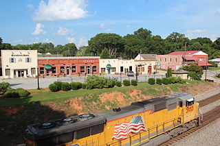
Buchanan is a city and the county seat of Haralson County, Georgia, United States. The population was 1,104 at the 2010 census, up from 941 at the 2000 census.
Waco is a city in Haralson County, Georgia, United States, located near the Alabama state line. The population was 516 at the 2010 census, up from 469 at the 2000 census.
Milner is a city in Lamar County, Georgia, United States. The population was 610 at the 2010 census, up from 522 at the 2000 census. Milner is part of Metro Atlanta.
Colbert is a city in Madison County, Georgia, United States. The population was 630 at the 2020 census.
The city of Lexington is the county seat of Oglethorpe County, Georgia, United States. The population was 239 at the 2000 census.
Hiram is a city in Paulding County, Georgia, United States. As of the 2020 census, the population is 4,929.
Young Harris is a city in Towns County, Georgia, United States. The population was 1,098 at the 2020 census. Young Harris is home to Young Harris College, after which it was named.