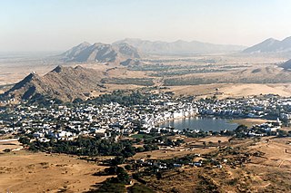
Pushkar is a temple town, near Ajmer City and headquarters of Pushkar tehsil in the Ajmer district in the Indian state of Rajasthan. It is situated about 10 km (6.2 mi) northwest of Ajmer and about 150 kilometres (93 mi) southwest of Jaipur. It is a pilgrimage site for Hindus and Sikhs. Pushkar has many temples. Most of the temples and ghats in Pushkar are from the 18th century and later, because many temples were destroyed during Muslim conquests in the area. Subsequently, the destroyed temples were rebuilt. The most famous among Pushkar temples is the red spired Brahma Temple. It is considered a sacred city by the Hindus particularly in Shaktism, and meat and eggs consumption are forbidden in the city as are alcohol and drugs. Pushkar is located on the shore of Pushkar Lake, which has many ghats where pilgrims bathe. Pushkar is also significant for its Gurdwaras for Guru Nanak and Guru Gobind Singh. One of the bathing ghats is called Gobind ghat built by the Sikhs in the memory of Guru Gobind Singh.
Beawar is a city in Beawar district of Indian state of Rajasthan. Beawar was the financial capital of Merwara state of Rajputana. As of 2011, the population of Beawar is 342,935. It is located 60 kilometres south from Ajmer, the divisional headquarter and 184 kilometres (114 mi) southwest of the state capital Jaipur, amidst Aravali hills. The city used to be a major center for trade, especially in raw cotton, and used to have cotton presses and the Krishna cotton mills. Currently, major industries include mineral-based units, machine-based units, machine tools and accessories, pre-stressed concrete pipes, plastic products, textiles, wooden furniture and asbestos cement pipes. Beawar is the largest producer of cement in northern India and home to Shree Cement. It is situated in a mineral-rich region having reserves of feldspar, quartz, asbestos, soapstone, magnesite, calcite, limestone, mica, emerald, granite, and masonry stone. Reserves of barytes, fluorite, wollastonite and vermiculite have also been found. Nearest airports are Jodhpur (145 km), Kishangarh and Jaipur (190 km). It is also connected by RSRTC operated buses to all parts of Rajasthan, and neighboring Delhi NCR, Ahmedabad (Gujarat), Gwalior. It also has railway connectivity with Delhi, Mumbai, Ahmadabad, Bangalore (bi-weekly), Haridwar, Dehradun (weekly), Bareilly and Muzzafarpur.

Ajmer district is a district in the Indian state of Rajasthan. It is part of the Ajmer division–one of the ten administrative divisions of Rajasthan. The city of Ajmer is the district headquarters. The district is situated in the center of Rajasthan, and is bounded by Didwana Kuchaman district to the north, Jaipur Rural and Dudu to the north-east, Tonk to the east, Kekri and Beawar to the south, and Nagaur to the west. It has an area of 8,481 km2 (3,275 sq mi), and a population of 2,583,052.

Bharatpur District is a district in Rajasthan state in western India. The city of Bharatpur is the District Headquarters, Division Headquarters and Headquarters of Bharatpur Police Range of Rajasthan Police. Bharatpur District is a part of National Capital Region of India Delhi.
Bhilwara District is a district of the state of Rajasthan in western India. The city of Bhilwara is the district headquarters.
Nana is a village in the Bali, tehsil of Pali District of the Rajasthan state in India. It is located three kilometres from the railway station of the same name on the Ahmedabad-Ajmer railway line. Virampura, Bhagal, Chamunderi, Velar, Bhimana, Amalia, Serla, Chimanpura are nearly village. Pindwada-Bali road is just passing near by Nana. Virampura is close to Nana just one km. Nana just became sub-block division declared. Nana police station is also located at railway station just two km from town.nearby city is pindwara 20 km, Sumerpur 40 km, Sheoganj 40 km, Shirohi 42 km, Aburoad 70 km from Nana. nearest airport is udaipur 120 km away. and jodhpurs is 200 km. District headquarter pali is 100 km from Nana.
Chhapar is a small town and a municipality in Churu district in the state of Rajasthan, India. Chhapar and Tal chhapar is located in the Churu district of Northwestern Rajasthan in the Shekhawati region of India. It is 210 km from Jaipur and situated on the road from Ratangarh to Sujangarh. The Tal Chappar lies in the Sujangarh Tehsil of Churu district. It lies on the Nokha-Sujangarh state highway and is situated at a distance of 85 km from Churu and about 132 km from Bikaner. The nearest railway station is Chappar which lies on Degana-Churu-Rewari broad gauge line of Northern Western Railways. The nearest Airport is Jaipur International Airport (Sanganer) which is at a distance of 215 km from Chappar. It is known for black bucks but it is also home to a variety of birds. Here is a famous sanctuary known as Tal Chhapar Sanctuary
Deoli is a city situated at the point at which Tonk, Shahpura, Kekri and Bundi districts meet, though the bulk of the city is located in Shahpura and Tonk districts. It is officially a part of Tonk district. It is the tehsil headquarters of the Deoli tehsil.
Jobner is a tehsil headquarter and one of the oldest municipalities in Jaipur district in the Indian state of Rajasthan.
Rajakhera is a city and a municipality situated near the banks of the Chambal River in Dholpur district in the Eastern part of the Indian state of Rajasthan. Its part of Braj region and the local language has Braj Bhasha dialect. The culture is fused with Rajasthan and its border states.
Uniara is a town and a municipality in Tonk district in the Indian state of Rajasthan. It is a tehsil of the Tonk district.

Neemrana is an ancient historical town in Kot Behror of Rajasthan, India, 66 km (41 mi) from Alwar city, 122 km (76 mi) from New Delhi and 150 km (93 mi) from Jaipur, on the Delhi - Jaipur highway in Neemrana tehsil. It was one of the three capitals of the Chauhans of Ajmer and the last refuge of their descendants after the loss of Delhi. It is between Behror and Shahajahanpur.

Rajasthan is one of the most popular tourist destinations in India, for both domestic and international tourists. Rajasthan attracts tourists for its historical forts, palaces, art and culture with its slogan "Padharo Mhare Desh " The capital city, Jaipur, also known as Pink City, is a very popular tourist destination and is a part of the Golden Triangle. The Walled City of Jaipur is only the second Indian city to be recognized as a UNESCO World Heritage Site, after Ahmedabad.
Paota is a municipality and headquarter of eponymous Paota tehsil in Kot Behror district 20 kilometres (12 mi) north of Jaipur and 170 kilometres (110 mi) southeast of Delhi on Highway NH-48 in Rajasthan state, India. Paota is famous for its extensive market and low cost products.

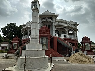
Nareli Jain Temple or Shri Gyanodaya Tirth Kshetra, is a new Jain temple located on the outskirts of Ajmer 7 kilometers from the city center and 128 kilometers west of Jaipur on the main national highway 8.
Nasopur is a village in Kotkasim, Tehsil Alwar district, in the Indian state of Rajasthan. It is located around 75 km south of Delhi, 75 km north of Alwar, and about 200 km north of Jaipur, the capital of Rajasthan. Nasopur is part of Greater Bhiwadi and National Capital Region (NCR).
Mahtawas is a village in Neemrana tehsil, Alwar district, Rajasthan state, India. It is a part of the National Capital Region.
Inana is a village in Mundwa Tehsil in Nagaur district in the Indian state of Rajasthan. It belongs to the Ajmer division of Rajasthan. It is located 13 km east from district headquarters in Nagaur, 8 km from Mundwa main town and 232 km from state capital Jaipur. The postal code of Inana is 341026.

Todgarh Raoli Wildlife Sanctuary is a wildlife sanctuary in Rajasthan, India. Spread over the Ajmer, Pali and Rajsamand districts of the state, it was established in 1983. It occupies about 495 km2 of tropical deciduous forests and grassland. Major wildlife includes leopard, wild boar, chinkara, common langur, sloth bears and Indian wolf. Also, about 143 bird species were recorded here in the 2013 survey. Nearest major town is Ajmer, which is 105 km away. Ajmer Junction Railway Station and Beawar Railway Station are the nearest railheads.
Ajaysar is a village in Ajmer tehsil of Ajmer district of Rajasthan state in India. It is situated in the rural region of Ajmer division at an elevation of 466 meters above sea level.

