Tatum, Texas

Last updated

Tatum, Texas
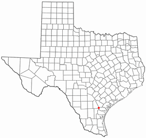
TXMap-doton-Tatum.PNG
Location of Tatum, Texas
Rusk County Tatum.svg
Coordinates: 32°18′53″N94°31′8″W / 32.31472°N 94.51889°W / 32.31472; -94.51889
Country Flag of the United States.svg United States
State Flag of Texas.svg  Texas
Counties Rusk, Panola
Area
[1]
  Total3.78 sq mi (9.80 km2)
  Land3.78 sq mi (9.80 km2)
  Water0.00 sq mi (0.00 km2)
Elevation
338 ft (103 m)
Population
 (2020)
  Total1,342
  Density365.94/sq mi (141.28/km2)
Time zone UTC-6 (Central (CST))
  Summer (DST) UTC-5 (CDT)
ZIP code
75691
Area code 903
FIPS code 48-71924 [2]
GNIS feature ID1369625 [3]
Website tatumtexas.com

Tatum is a city in Rusk and Panola counties in Texas, United States. Its population was 1,342 at the 2020 census.

Contents

History

Tatum was settled in the 1840s by Albert Tatum and his second wife, Mary C. (Rippetoe) Tatum. In 1848, they built a large plantation there. In 1885, the Santa Fe Railway came through, and the town was divided into individual lots. One of their sons, Paul "Uncle Fox" Tatum, who studied architecture in New York, laid out the streets. He became the postmaster in 1886. The city of Tatum lies along Trammel's Trace, an old trade route; a marker at the south end of town commemorates it. In the city park stands the restored Santa Fe depot.

Albert Tatum was born on August 12, 1810, in Hancock County, Georgia, the son of William Tatum and Alice B. (Dent) Tatum. Albert Tatum first married Rebecca Elizabeth Ann Menefee about 1837 in Chambers County, Alabama. They were the parents of one son, William C. Tatum, who was born on June 25, 1838, in Chambers County, Alabama.

After the death of his first wife on December 31, 1840, in Chambers County, Albert Tatum married Mary C. Rippetoe on September 22, 1841, in Tallapoosa County, Alabama. At one time, Albert Tatum owned over 4,000 acres (16 km2) of land around the current town of Tatum.

After the town's first bank was established in 1903, things got bad early in the 20th century, as a tornado destroyed part of the town in 1904. The next year, a fire destroyed almost all of the north side of town. [4]

Geography

Tatum is located at 32°18′53″N94°31′8″W / 32.31472°N 94.51889°W / 32.31472; -94.51889 (32.314853, –94.518875). [5]

According to the United States Census Bureau, the city has a total area of 3.8 square miles (9.8 km2), all land.

Climate

The climate in this area is characterized by hot, humid summers and generally mild to cool winters. According to the Köppen climate classification, Tatum has a humid subtropical climate, Cfa on climate maps. [6]

Demographics

Historical population
CensusPop.Note
1940 427
1950 59940.3%
1960 542−9.5%
1970 68426.2%
1980 1,33995.8%
1990 1,289−3.7%
2000 1,175−8.8%
2010 1,38517.9%
2020 1,342−3.1%
U.S. Decennial Census [7]
Tatum racial composition as of 2020 [8]
(NH = Non-Hispanic) [lower-alpha 1]
RaceNumberPercentage
White (NH)72854.25%
Black or African American (NH)21916.32%
Native American or Alaska Native (NH)20.15%
Asian (NH)40.3%
Some Other Race (NH)10.07%
Mixed/multiracial (NH)604.47%
Hispanic or Latino 32824.44%
Total1,342

As of the 2020 United States census, there were 1,342 people, 494 households, and 320 families residing in the city.

As of the census [2] of 2000, 1,175 people, 459 households, and 324 families resided in the city. The population density was 309.9 inhabitants per square mile (119.7/km2). The 523 housing units averaged 137.9/sq mi (53.3/km2). The racial makeup of the city was 73.62% White, 16.43% African American, 0.51% Native American, 0.09% Pacific Islander, 7.15% from other races, and 2.21% from two or more races. Hispanics or Latinos of any race were 17.62% of the population.

Of the 459 households, 35.3% had children under the age of 18 living with them, 52.1% were married couples living together, 13.5% had a female householder with no husband present, and 29.4% were not families. About 27.5% of all households were made up of individuals, and 13.9% had someone living alone who was 65 years of age or older. The average household size was 2.56 and the average family size was 3.14.

In the city, the population was distributed as 28.9% under 18, 10.0% from 18 to 24, 27.3% from 25 to 44, 21.3% from 45 to 64, and 12.5% who were 65 or older. The median age was 33 years. For every 100 females, there were 90.4 males. For every 100 females 18 and over, there were 84.7 males.

The median income for a household in the city was $25,000, and for a family was $30,119. Males had a median income of $26,719 versus $19,063 for females. The per capita income for the city was $13,181. About 20.4% of families and 25.4% of the population were below the poverty line, including 34.8% of those under age 18 and 20.2% of those age 65 or over.

Education

The City of Tatum is served by the Tatum Independent School District. A small portion of the town is also within the Beckville ISD.

Attractions

Martin Creek Lake State Park is located 4 miles (6 km) southeast of Tatum. The park was deeded to the Texas Parks and Wildlife Department by Texas Utilities and opened to the public in 1976. The park is located on 5,000-acre (20 km2) Martin Creek Lake, constructed to provide cooling water for the lignite-fired Martin Lake Power Plant. [11] Martin Creek Lake State Park provides excellent, year-round fishing, camping, wildlife observation and photography, picnicking, boating, water skiing, unsupervised lake swimming, backpacking, and hiking. Annual events at Martin Creek Lake State Park include Christmas in the Piney Woods (first weekend in December), Fourth of July Bike Parade, and the Annual Family Easter Egg Hunt. The park also offers regular programs most weekends, including Geocaching 101, Dutch Oven Cooking (4th Saturday of every month), Guided Hikes, Guided Paddling Programs, Star Gazing, and Art in the Parks craft programs. [12]

Major highways

Notable people

See also

Notes

  1. Note: the US Census treats Hispanic/Latino as an ethnic category. This table excludes Latinos from the racial categories and assigns them to a separate category. Hispanics/Latinos can be of any race. [9] [10]

Related Research Articles

<span class="mw-page-title-main">Clay County, Texas</span> County in Texas, United States

Clay County is a county located in the U.S. state of Texas. As of the 2020 census, its population was 10,218. The county seat is Henrietta. The county was founded in 1857 and later organized in 1860. It is named in honor of Henry Clay, famous American statesman, Kentucky Senator and United States Secretary of State.

<span class="mw-page-title-main">Tom Green County, Texas</span> County in Texas, United States

Tom Green County is a county located on the Edwards Plateau in the U.S. state of Texas. As of the 2020 census, its population was 120,003. Its county seat is San Angelo. The county was created in 1874 and organized the following year. It is named for Thomas Green, who was a Confederate soldier and lawyer. Tom Green County is included in the San Angelo metropolitan statistical area; the county is home to Goodfellow Air Force Base, as well as Angelo State University, part of the Texas Tech University System.

<span class="mw-page-title-main">Houston County, Texas</span> County in Texas, United States

Houston County is a county located in the U.S. state of Texas. As of the 2020 census, its population was 22,066. Its county seat is Crockett. Houston County was one of 46 entirely dry counties in the state of Texas, until voters in a November 2007 special election legalized the sale of alcohol in the county.

<span class="mw-page-title-main">Hardeman County, Texas</span> County in Texas, United States

Hardeman County is a county located in the U.S. state of Texas. As of the 2020 census, its population was 3,549. The county seat and largest city is Quanah. The county was created in 1858 and later organized in 1884. It is named for two brothers, Bailey Hardeman and Thomas Jones Hardeman, early Texas politicians and legislators. Hardeman County was one of 46 prohibition or entirely dry counties in the state of Texas until November 2006, when voters approved referendums to permit the legal sale of alcoholic beverages for on- and off-premises consumption.

<span class="mw-page-title-main">Rock County, Minnesota</span> County in Minnesota, United States

Rock County is a county located in the southwestern corner of the U.S. state of Minnesota. According to the 2020 census, its population was 9,704. The county seat is Luverne. It is located within the Sioux Falls MSA.

<span class="mw-page-title-main">Jennings, Florida</span> Town in the state of Florida, United States

Jennings is a town in Hamilton County, Florida, United States. The population was 749 at the 2020 census, down from 878 at the 2010 census.

<span class="mw-page-title-main">Bay Lake, Florida</span> City in Florida, United States

Bay Lake is a city in Orange County, Florida, United States. The population was 29 at the 2020 census. It is named after a lake that lies east of the Magic Kingdom. All four of the Walt Disney World Resort theme parks, and one of Walt Disney World's two water parks, are in Bay Lake, though all Disney parks in the region have mailing addresses in nearby Lake Buena Vista.

<span class="mw-page-title-main">Davenport, Florida</span> City in Florida, United States

Davenport is a city in Polk County, Florida, United States. It is part of the Lakeland–Winter Haven Metropolitan Statistical Area. The population was 9,043 at the 2020 Census. The city's population has increased dramatically since the 2010 Census, when the population was 2,888.

<span class="mw-page-title-main">Lake Hamilton, Florida</span> Town in the state of Florida, United States

Lake Hamilton is a town in Polk County, Florida, United States. The population was 1,537 at the 2020 census. It is part of the Lakeland–Winter Haven Metropolitan Statistical Area.

<span class="mw-page-title-main">Frankfort Square, Illinois</span> Census-designated place in Illinois, United States

Frankfort Square is a census-designated place (CDP) in Will County, Illinois, United States. Per the 2020 census, the population was 8,968.

<span class="mw-page-title-main">Gregory, South Dakota</span> City in South Dakota, United States

Gregory is a city in western Gregory County, South Dakota, United States. The population was 1,221 at the 2020 census.

<span class="mw-page-title-main">Quitaque, Texas</span> City in Texas, United States

Quitaque is a city in southeastern Briscoe County, Texas, United States. The town lies directly south of Caprock Canyon State Park and is a ranching and farming area in West Texas. The population was 342 at the 2020 census, and 411 at the 2010 census.

<span class="mw-page-title-main">Clear Lake Shores, Texas</span> City in Galveston County, Texas

Clear Lake Shores is a city in Galveston County, Texas, United States, located within the Houston–Sugar Land–Baytown metropolitan area. As of the 2020 census, the city population was 1,258.

<span class="mw-page-title-main">Kountze, Texas</span> City in Texas, United States

Kountze is a city in and the county seat of Hardin County, Texas, United States. The population was 1,981 at the 2020 census. The city is part of the Beaumont–Port Arthur Metropolitan Statistical Area.

<span class="mw-page-title-main">Lumberton, Texas</span> City in Texas, United States

Lumberton is a city in Hardin County, Texas, United States. The population was 13,554 at the 2020 census, up from 11,943 at the 2010 census. Lumberton is the home of Village Creek State Park. The city is part of the Beaumont–Port Arthur metropolitan area.

<span class="mw-page-title-main">Grapeland, Texas</span> City in Texas, United States

Grapeland is a city in Houston County, Texas, United States. Its population was 1,465 as of the 2020 census.

<span class="mw-page-title-main">Lovelady, Texas</span> City in Texas, United States

Lovelady is a town in Houston County, Texas, United States. The population was 570 at the 2020 census.

<span class="mw-page-title-main">Jacksboro, Texas</span> City in Texas, United States

Jacksboro is a city in Jack County, Texas, in the United States. Its population was 4,184 at the 2020 census. U.S. Highways 281 and 380, and Texas State Highways 114 and 199 intersect at Jacksboro, which is the county seat of Jack County.
<span class="mw-page-title-main">Mathis, Texas</span> City in Texas, United States

Mathis is a city in San Patricio County, Texas, United States. The population was 4,333 at the 2020 census.

<span class="mw-page-title-main">Merkel, Texas</span> City in Texas, United States

Merkel is a city in Taylor County, Texas, United States. Its population was 2,471 at the 2020 census. It is part of the Abilene metropolitan area.

References

  1. "2019 U.S. Gazetteer Files". United States Census Bureau. Retrieved August 7, 2020.
  2. 1 2 "U.S. Census website". United States Census Bureau . Retrieved January 31, 2008.
  3. "US Board on Geographic Names". United States Geological Survey. October 25, 2007. Retrieved January 31, 2008.
  4. Tatum at TexasEscapes
  5. "US Gazetteer files: 2010, 2000, and 1990". United States Census Bureau. February 12, 2011. Retrieved April 23, 2011.
  6. Climate Summary for Tatum, Texas
  7. "Census of Population and Housing". Census.gov. Retrieved June 4, 2015.
  8. "Explore Census Data". data.census.gov. Retrieved May 25, 2022.
  9. https://www.census.gov/ [ not specific enough to verify ]
  10. "About the Hispanic Population and its Origin". www.census.gov. Retrieved May 18, 2022.
  11. "Martin Creek Lake State Park History". Texas Parks & Wildlife Department. Retrieved February 15, 2018.
  12. Maloukis, Park Superintendent(2015)