Southeast Alaska, often abbreviated to southeast or southeastern, and sometimes called the Alaska(n) panhandle, is the southeastern portion of the U.S. state of Alaska, bordered to the east and north by the northern half of the Canadian province of British Columbia. The majority of southeast Alaska is situated in Tlingit Aaní, much of which is part of the Tongass National Forest, the United States' largest national forest. In many places, the international border runs along the crest of the Boundary Ranges of the Coast Mountains. The region is noted for its scenery and mild, rainy climate.

The term "United States," when used in the geographical sense, refers to the contiguous United States, Alaska, Hawaii, the five insular territories of Puerto Rico, Northern Mariana Islands, U.S. Virgin Islands, Guam, American Samoa, and minor outlying possessions. The United States shares land borders with Canada and Mexico and maritime borders with Russia, Cuba, The Bahamas, and many other countries, mainly in the Caribbeanin addition to Canada and Mexico. The northern border of the United States with Canada is the world's longest bi-national land border.

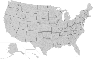
In the United States, a county or county equivalent is an administrative or political subdivision of a U.S. state or other territories of the United States which consists of a geographic area with specific boundaries and usually some level of governmental authority. The term "county" is used in 48 states, while Louisiana and Alaska have functionally equivalent subdivisions called parishes and boroughs, respectively. The specific governmental powers of counties vary widely between the states, with many providing some level of services to civil townships, municipalities, and unincorporated areas. Certain municipalities are in multiple counties; New York City is uniquely partitioned into five counties, referred to at the city government level as boroughs. Some municipalities have been consolidated with their county government to form consolidated city-counties, or have been legally separated from counties altogether to form independent cities. Conversely, counties in Connecticut, Rhode Island, eight of Massachusetts's 14 counties, and Alaska's Unorganized Borough have no government power, existing only as geographic distinctions.

The Southern United States, sometimes Dixie, also referred to as the Southern States, the American South, the Southland, Dixieland, or simply the South, is a geographic and cultural region of the United States. It is between the Atlantic Ocean and the Western United States, with the Midwestern and Northeastern United States to its north and the Gulf of Mexico and Mexico to its south.

The Mexican Cession is the region in the modern-day western United States that Mexico previously controlled, then ceded to the United States in the Treaty of Guadalupe Hidalgo in 1848 after the Mexican–American War. This region had not been part of the areas east of the Rio Grande that had been claimed by the Republic of Texas, which had been claiming independence since its Texas Revolution of 1836 and subsequent brief war for independence, followed afterwards a decade later by the American annexation and admitted statehood in 1845. It had not specified the southern and western boundary of the new state of Texas with New Mexico consisting of roughly 529,000 square miles (1,370,000 km2), not including any Texas lands, the Mexican Cession was the third-largest acquisition of territory in U.S. history, surpassed only by the 827,000-square-mile (2,140,000 km2) Louisiana Purchase of 1803 and the later 586,000-square-mile (1,520,000 km2) Alaska Purchase from Russia in 1867.

The territory of the United States and its overseas possessions has evolved over time, from the colonial era to the present day. It includes formally organized territories, proposed and failed states, unrecognized breakaway states, international and interstate purchases, cessions, and land grants, and historical military departments and administrative districts. The last section lists informal regions from American vernacular geography known by popular nicknames and linked by geographical, cultural, or economic similarities, some of which are still in use today.

The Eastern United States, often abbreviated as simply the East, is a macroregion of the United States located to the east of the Mississippi River. It includes 17–26 states and Washington, D.C., the national capital.

The classification of the Indigenous peoples of the Americas is based upon cultural regions, geography, and linguistics. Anthropologists have named various cultural regions, with fluid boundaries, that are generally agreed upon with some variation. These cultural regions are broadly based upon the locations of the Indigenous peoples of the Americas from early European and African contact beginning in the late 15th century. When Indigenous peoples have been forcibly removed by nation-states, they retain their original geographic classification. Some groups span multiple cultural regions.

The Southeastern United States, also referred to as the American Southeast, the Southeast, or the South, is a geographical region of the United States located in the eastern portion of the Southern United States and the southern portion of the Eastern United States. The region includes a core of states that reaches north to Maryland and West Virginia, bordering the Ohio River and Mason–Dixon line, and stretches west to Arkansas and Louisiana.

The North American Cordillera, sometimes also called the Western Cordillera of North America, the Western Cordillera, or the Pacific Cordillera, is the North American portion of the American Cordillera, the mountain chain system along the Pacific coast of the Americas. The North American Cordillera covers an extensive area of mountain ranges, intermontane basins, and plateaus in Western and Northwestern Canada, Western United States, and Mexico, including much of the territory west of the Great Plains.
USA Volleyball (USAV) is a non-profit organization which is recognized as the national governing body of volleyball in the United States by the Fédération Internationale de Volleyball (FIVB) and the United States Olympic Committee (USOC). It is headquartered in Colorado Springs, Colorado, and was founded by the YMCA of the USA. The organization is responsible for selecting and supporting US national teams that compete in FIVB-sanctioned international volleyball and beach volleyball competitions such as the Olympic Summer Games. USA Volleyball is also charged with fostering the development of the sport of volleyball within the United States through involvement with its forty Regional Volleyball Associations (RVAs).

The Unitarian Universalist Association, an association of Unitarian Universalist Congregations in the United States of America, is composed of 19 Districts.

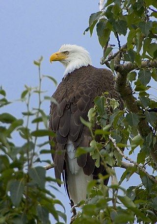
The fauna of the United States of America is all the animals living in the Continental United States and its surrounding seas and islands, the Hawaiian Archipelago, Alaska in the Arctic, and several island-territories in the Pacific and in the Caribbean. The U.S. has many endemic species found nowhere else on Earth. With most of the North American continent, the U.S. lies in the Nearctic, Neotropic, and Oceanic faunistic realms, and shares a great deal of its flora and fauna with the rest of the American supercontinent.

Dixie, also known as Dixieland or Dixie's Land, is a nickname for all or part of the Southern United States. While there is no official definition of this region, or the extent of the area it covers, most definitions include the U.S. states below the Mason–Dixon line that seceded and comprised the Confederate States of America, almost always including the Deep South. The term became popularized throughout the United States by songs that nostalgically referred to the American South.

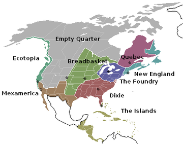
American Nations: A History of the Eleven Rival Regional Cultures of North America is an American non-fiction book written by Colin Woodard and published in 2011. Woodard proposes a framework for examining American history and current events based on a view of the country as a federation of eleven nations, each defined by a shared culture established by each nation's founding population.


