The Tudor Trail

Last updated

The Tudor Trail

Eden Valley Walk and National Cycleway 12 - geograph.org.uk - 1526201.jpg

The Tudor Trail and National Cycleway 12 near Leigh (heading to Tonbridge)
Length 6 mi (10 km)
Location Kent
Trailheads

Tonbridge Castle
51°10′29″N0°11′02″E / 51.1747°N 0.1838°E / 51.1747; 0.1838 (The Tudor Trail)

Contents

Penshurst Place
51°11′48″N0°16′26″E / 51.1966°N 0.2738°E / 51.1966; 0.2738 (The Tudor Trail)
Use Cycling and Hiking,
Hiking details
Trail difficulty Easy
Months All year
Sights Wealden countryside

The Tudor Trail is a 6-mile multi-user linear route between 2 historic buildings in the Wealden countryside. It is also part of 'Regional Route 12' of the National Cycle Network.

National Cycle Network national cycling route network of the United Kingdom

The National Cycle Network (NCN) is the national cycling route network of the United Kingdom, which was established to encourage cycling throughout Britain, as well as for the purposes of bicycle touring. It was created by the charity Sustrans who were aided by a £42.5 million National Lottery grant. The 14,000 mile network was used for over 230 million trips in 2005.

Route

Tonbridge Castle Gatehouse Tonbridge Castle Gatehouse - N Side, Tonbridge, Kent - geograph.org.uk - 52574.jpg
Tonbridge Castle Gatehouse

The trail starts at Tonbridge Castle, then leads through Haysden Country Park (around Barden Lake), then through the village of Lower Haysden, it then passes under the Tonbridge by-pass (part of the A21) via a quiet lane, then it uses a bridleway to link back to a portion of Haysden Country Park. It meets the 'Eden Valley Walk' (along distance path between Penshurst and Edenbridge). They then head along 'The Straight Mile' which is the remains of a canal built in the 1829 to join Penshurst to the navigable part of the River Medway. The canal was never completed or ever used. [1] Then mile ends near Ensfield Road which passes over the River Medway. The route then heads along a bridleway to Killick's Bank farm. The route then heads to a section of the route with the only slight climb of the route, heading up to Wells Place Farm. The farm is on the Penshurst Estate and the route then heads down to Penshurst Place, the destination of the route. [2]

Tonbridge Castle Grade I listed castle in the United Kingdom

Tonbridge Castle is situated in Tonbridge, Kent, England.

Haysden Country Park

Haysden Country Park is a 64-hectare (160-acre) country park and Local Nature Reserve on the outskirts of Tonbridge in Kent. It is owned by Tonbridge and Malling Borough Council, the Highways Agency, Network Rail and the Environment Agency, and managed by the council.

A21 road (England) trunk road in Southern England

For other roads with the same name see List of A21 roads.

The route has been recommended by Bradley Wiggins as one of the top cycling routes in the country. [3] [4]

Bradley Wiggins British former professional road and track racing cyclist

Sir Bradley Marc Wiggins, CBE is a British former professional road and track racing cyclist, who competed professionally between 2001 and 2016. Nicknamed "Wiggo", he began his cycling career on the track, but made the transition to road cycling and is one of the few cyclists in the modern era to gain significant elite level success in both those forms of professional cycling. He is the only rider to have combined winning both World and Olympic championships on both the track and the road, as well as winning the Tour de France, and holding the iconic track hour record. In addition, he has worn the leader's jersey in each of the three Grand Tours of cycling and held the world record in team pursuit on multiple occasions.

Some guides mention the trail continuing (past Penshurst) to Hever Castle via Chiddingstone, extending the trail to 10miles (16 km). [5] [6]

Hever Castle Grade I listed historic house museum in Hever, United Kingdom

Hever Castle is located in the village of Hever, Kent, near Edenbridge, 30 miles (48 km) south-east of London, England. It began as a country house, built in the 13th century. From 1462 to 1539, it was the seat of the Boleyn family.

Chiddingstone a village located in Sevenoaks, United Kingdom

Chiddingstone is a village and civil parish in the Sevenoaks District of Kent, England. The parish is located on the River Eden between Tonbridge and Edenbridge. The village of Chiddingstone Causeway is included in the parish. It is an example of a Tudor one-street village.

The route is mentioned in the 'AA guide Cycling in the SE of England'.

Recommended OS maps to use are OS Explorer 147, OS Landranger 188.

Penshurst Place Penshurst Place, Tonbridge, Kent - geograph.org.uk - 52553.jpg
Penshurst Place

Related Research Articles

River Medway river in South East England

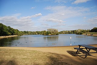
The River Medway is a river in South East England. It rises in the High Weald, Sussex and flows through Tonbridge, Maidstone and the Medway conurbation in Kent, before emptying into the Thames Estuary near Sheerness, a total distance of 70 miles (113 km). About 13 miles (21 km) of the river lies in Sussex, with the remainder being in Kent.

South Downs Way

The South Downs Way is a long distance footpath and bridleway running along the South Downs in southern England. It is one of 15 National Trails in England and Wales. The trail runs for 160 km (100 mi) from Winchester in Hampshire to Eastbourne in East Sussex, with about 4,150 m (13,620 ft) of ascent and descent.

Tonbridge and Malling Non-metropolitan district in England

Tonbridge and Malling is an English local government district with borough status in Kent, England. It is in the mid-west of the county.

Hildenborough village in Kent

Hildenborough is a village and rural parish in the borough of Tonbridge and Malling in Kent, England. It is located 2 miles (3.2 km) north-west of Tonbridge and 5 miles (8 km) south-east of Sevenoaks. The village lies in the River Medway valley, near the North Downs, in an area known as The Weald.

Penshurst village in Kent, England

Penshurst is a historic village and civil parish located in a valley upon the northern slopes of the Kentish Weald, at the confluence of the River Medway and the River Eden, within the Sevenoaks district of Kent, England.

Arriva Southern Counties Bus operator in Surrey, West Sussex, East Sussex, Kent and Essex

Arriva Southern Counties is a bus operator in Surrey, West Sussex, East Sussex, Kent and Essex in England. It is a subsidiary of Arriva UK Bus.

The Midshires Way is a long-distance footpath and bridleway that runs for 230 miles (370 km) from the Chiltern Hills from near Bledlow in Buckinghamshire, through the Midlands counties of Northamptonshire, Leicestershire, Nottinghamshire and Derbyshire, to Stockport, Greater Manchester. It also links several other long-distance walking routes or trackways including The Ridgeway, the Pennine Bridleway and the Trans Pennine Trail.

Pennine Bridleway

The Pennine Bridleway is a new National Trail in Northern England.

Redhill–Tonbridge line

The Redhill–Tonbridge line is a railway line running from Redhill, Surrey to Tonbridge, Kent in southeast England. It branches off the Brighton Main Line at Redhill and, after 20 miles, joins the South Eastern main line at Tonbridge

The following is a list of recreational walks in Kent, England.

Mary Towneley Loop

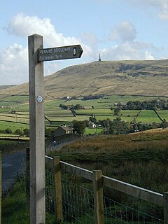
The Mary Towneley Loop is a 47-mile (76 km) circular route that forms part of the Pennine Bridleway National Trail, along the borders of Lancashire and Yorkshire. The loop was opened in 2002, the first section of the Pennine Bridleway.

The Wealdway, Kent and East Sussex, is a public footpath that runs for 83 miles / 134 km from Gravesend, Kent on the Thames estuary, to the A259 at Eastbourne, 3 km north of Beachy Head.

National Cycle Route 1 route of the National Cycle Network in the UK

National Cycle Route 1 is a route of the National Cycle Network, running from Dover to Shetland. The 1,695-mile-long (2,728 km) cycle-path is located in the United Kingdom.

The River Medway in England flows for 70 miles (113 km) from Turners Hill, in West Sussex, through Tonbridge, Maidstone and the Medway Towns conurbation in Kent, to the River Thames at Sheerness, where it shares the latter's estuary. The Medway Navigation runs from the Leigh Barrier south of Tonbridge to Allington just north of Maidstone. It is 19 miles (31 km) in length. The Environment Agency is the navigation authority responsible for the navigation.

High Weald Landscape Trail

The High Weald Landscape Trail (HWLT) is a 145-kilometre (90 mi) route in England between Horsham, West Sussex and Rye, East Sussex, designed to pass through the main landscape types of the High Weald Area of Outstanding Natural Beauty (AONB). It does not follow the highest ground, and the eastern section is only a few feet above sea level. It keeps to the northern edge of the High Weald except in the west where it runs close to the southern edge for a short distance.

The New Lipchis Way is a 60.8 kilometres (37.8 mi) long distance footpath which runs from Liphook in Hampshire to West Wittering in West Sussex. Running north–south across the Western Weald and South Downs to the Sussex coastal plain and Chichester Harbour the path crosses several geological rock strata and their associated soils and habitats. Landmarks on the route include Cowdray ruins, Goodwood Racecourse, the Trundle, Chichester Cathedral and the city walls, and East Head at West Wittering.

The Heron Trail is 15 12-mile (24.9 km) long cycling trail that links with National Cycle Route 1 between Higham and Strood, then it heads around the Hoo Peninsula via Regional route 18 passing through 'Hoo St Werburgh', 'High Halstow' and 'Cliffe' before returning to Higham. It has a mixture of rural and maritime interest, with views of the River Medway and River Thames.

References

  1. "1829: James Christie and the Penshurst Canal". tonbridgehistory.org.uk. Retrieved 30 September 2014.
  2. "Cycle rides - Tudor Trail". kent.gov.uk. Retrieved 30 September 2014.
  3. Gorringe, Anne (10 April 2014). "On your bike! Channel Bradley Wiggins with Britain's best cycling trips". The Express. Retrieved 30 September 2014.
  4. Kasper, Roger (11 April 2014). "Bradley Wiggins picks Tonbridge as a great place to cycle". Kent and Sussex Courier. Retrieved 30 September 2014.
  5. Samantha Cook, Claire Saunders Rough Guide to Kent, Sussex and Surrey The Tudor Trail at Google Books
  6. "Tudor trail, Kent". The Guardian. 6 May 2012. Retrieved 30 September 2014.