
Bradwell is an ancient village and modern district in Milton Keynes, Buckinghamshire, England, situated approximately 1 mile (1.6 km) north-west of Central Milton Keynes. It has also given its name to a modern civil parish that is part of the City of Milton Keynes. The village was adjacent to Bradwell Abbey, a Benedictine priory, founded in 1155 and dissolved in about 1540, but the abbey and its immediate environs were always a separate ecclesiastical parish.

Eaton Bray is a village and civil parish in Bedfordshire, England. It is situated about three miles south-west of the town of Dunstable and is part of a semi-rural area which extends into the parish of Edlesborough. In the 2011 United Kingdom census the population of the parish was recorded as 2,585.
Haversham is a village and former civil parish, now in the parish of Haversham-cum-Little Linford, in the City of Milton Keynes unitary authority area, in Buckinghamshire, England. It is situated to the north of the Milton Keynes urban area, near Wolverton and about 5 miles (8 km) north of Central Milton Keynes.

Selby District was a local government district of North Yorkshire, England, from 1974 to 2023. Its council was based in the town of Selby. The district had a population of 83,449 at the 2011 Census. The southernmost district of North Yorkshire, it bordered the City of York unitary authority, the Borough of Harrogate in North Yorkshire, the City of Leeds and City of Wakefield districts in West Yorkshire, the City of Doncaster in South Yorkshire, and the ceremonial county of the East Riding of Yorkshire.

Sykehouse is a village and civil parish in the City of Doncaster, South Yorkshire, England, on the border with the East Riding of Yorkshire. It was part of the West Riding of Yorkshire until 1974. It had a population of 438 in 2001, increasing to 515 at the 2011 Census.

Clayton is a village in the west of the City of Doncaster, South Yorkshire, England, on the border with West Yorkshire. It lies to the north of Thurnscoe at an elevation of around 80 metres above sea level.

A civil parish is a country subdivision, forming the lowest unit of local government in England. There are 94 civil parishes in the ceremonial county of South Yorkshire, most of the county being unparished. At the 2001 census, there were 360,191 people living in the parishes, increasing to 369,220 in 2011, accounting for 27.5 per cent of the county's population.

Eccleston is a village and civil parish of the Borough of Chorley in Lancashire, England. It is beside the River Yarrow, and was formerly an agricultural and later a weaving settlement.

Clayton-le-Woods is a large village and civil parish of the Borough of Chorley, in Lancashire, England. According to the census of 2001, it has a population of 14,528. At the 2011 census the population of Cuerden civil parish was included within Clayton-le-Woods, giving a total of 14,532.
Whitley is a village in the Selby district of North Yorkshire, England, close to the Aire and Calder Navigation and the M62 motorway. The population of the village at the 2001 census was recorded as being 574, which had risen to 1,021 by the time of the 2011 census. In 2015, North Yorkshire County Council estimated the population to have risen again to 1,110. It was historically part of the West Riding of Yorkshire until 1974.

Balne is a village and civil parish in the Selby District of North Yorkshire in England, south of Selby. According to the 2001 census the parish had a population of 231, reducing to 224 at the 2011 census. The parish is bound to the north-east by the East Riding of Yorkshire and to the south by the Metropolitan Borough of Doncaster in South Yorkshire.

Barnby Dun with Kirk Sandall is a civil parish in the Metropolitan Borough of Doncaster in South Yorkshire, England. According to the 2001 census it had a population of 8,524 and by 2011 this had risen to 8,592. The parish covers Barnby Dun and Kirk Sandall, both parts of the Doncaster urban area.

Bickerstaffe is a village and civil parish in the West Lancashire district of Lancashire, England. According to the 2001 Census the population of the civil parish was 1,196, reducing to 1,180 at the 2011 census, although the population of the electoral ward, which includes Lathom South, was slightly greater at 2,013, reducing to 1,988 at the 2011 census. The village is near junction 3 of the M58 motorway, and is about four miles west of Skelmersdale.
Brodsworth is a village, civil parish and suburb of Doncaster in the City of Doncaster district in South Yorkshire, England. Situated about five miles north-west of Doncaster. According to the 2001 census, it had a population of 2,875, increasing to 2,936 at the 2011 Census.
Pollington is a village and civil parish in the East Riding of Yorkshire, England. It is situated approximately 2 miles (3.2 km) south-west of the town of Snaith and 1 mile (1.6 km) south of the M62 motorway. It lies on the north bank of the Aire and Calder Navigation.

Hook is a village and civil parish in the East Riding of Yorkshire, England. It is situated approximately 1.5 miles (2.4 km) north-east of Goole town centre and lies on the west bank of the River Ouse.

Thorpe Willoughby is a village and civil parish in the Selby District of North Yorkshire, England. The village is situated just off the A1238 and is in close proximity to Selby.

Fishlake is a village and civil parish in the Metropolitan Borough of Doncaster. It was historically part of the West Riding of Yorkshire until 1974. In 2001 it had a population of 628, increasing to 682 at the 2011 Census. It was mentioned in the Domesday Book where the name is given as fiscelac, from Old English fisc-lacu, 'fish-stream'.
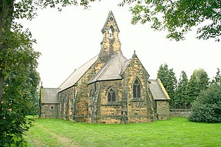
High Melton is a village and civil parish in the City of Doncaster in South Yorkshire, England. It had a population of 339 in 2001, reducing to 300 at the 2011 Census.

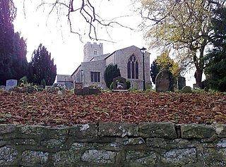
Moss is a village and civil parish in the City of Doncaster in South Yorkshire, England. The population of the parish at the 2011 Census was 389, an increase from 290 at the 2001 Census. From 1871 to 1953 the village was served by Moss railway station.


