Toton

Last updated • 5 min readFrom Wikipedia, The Free Encyclopedia

Toton
Swiney Way Toton - geograph.org.uk - 1155493.jpg
Swiney Way in February 2009.
Nottinghamshire UK location map.svg
Red pog.svg
Toton
Location within Nottinghamshire
Population8,238 (Ward 2011)
OS grid reference SK 50166 34692
District
Shire county
Region
Country England
Sovereign state United Kingdom
Post town NOTTINGHAM
Postcode district NG9
Dialling code 0115
Police Nottinghamshire
Fire Nottinghamshire
Ambulance East Midlands
UK Parliament
List of places
UK
England
Nottinghamshire
52°54′25″N1°15′14″W / 52.907°N 1.254°W / 52.907; -1.254

Toton /ˈttən/ is a large suburban village in the Borough of Broxtowe in Nottinghamshire, England. It forms part of the built-up area of Beeston, [1] which in turn forms part of the wider Nottingham Urban Area. The population of the electoral ward of Toton and Chilwell Meadows was 7,298 in the 2001 census; [2] it increased to 8,238 at the 2011 census. [3]

Contents

Until 1974, Toton was part of Beeston and Stapleford Urban District, having been in Stapleford Rural District until 1935. The border with Derbyshire lies immediately to the west.

Toton adjoins the Chetwynd Barracks (also known as Chilwell Depot), which forms a boundary to the east; the Erewash Valley railway line and Toton traction maintenance depot form a boundary to the west.

History

Although the village of Toton has existed since at least Norman times, little is known of its history. It is known that Toton parish at one time encompassed a much larger area than is now apparent, including much of what is now Attenborough village; it shared a church (probably on the site of St. Mary's, Attenborough) with the neighbouring Chilwell parish, an arrangement that was unusual for the times. [4]

A train leaving Toton Sidings to deliver coal to nearby Ratcliffe-on-Soar Power Station Coal for the power stations - geograph.org.uk - 1659203.jpg
A train leaving Toton Sidings to deliver coal to nearby Ratcliffe-on-Soar Power Station

The village itself was, for most of its history, small and dominated by agriculture. It then grew principally because of Toton Sidings (see Toton Traction Maintenance Depot), a huge marshalling yard of the Midland Railway, where coal mined from Nottinghamshire coal fields would be sorted and distributed across Great Britain. The area's population grew substantially during World War I when most of the area of level ground between Chilwell and Toton was occupied by the National Shell Filling Factory No. 6 and the original direct route between Chilwell and Toton became a gated military road, now known as Chetwynd Road; this site is now known as Chetwynd Barracks.

As a result, the nature of the village changed drastically in the twentieth century. Almost all the agricultural land (mostly orchards) to the north of the A6005 was developed with housing. A few of the old orchard trees were retained in some gardens. Most of the old farmhouses were demolished and perhaps twelve buildings remain that are pre-1900. Almost no visible traces remain of Toton's agricultural past.

Governance

Toton was historically a township in the parish of Attenborough. It became a civil parish in 1866. [5] In 1931 the parish had a population of 644. [6] On 1 April 1935 the parish was abolished and merged into Beeston and Stapleford urban district. [7] Beeston and Stapleford Urban District was abolished in 1974 to become part of Broxtowe. No successor parish was created and it became an unparished area. [8]

Amenities

Parks and open space

Manor Park (built on the site of the old Manor Farm) is a popular council park, with well-maintained cricket and football pitches, tennis courts and a bowling green. This joins onto Banks Road Open Area, an extended strip of land along and between the banks of the River Erewash and its overflow channel; it stretches up along Toton Bank. These areas are managed collectively as Toton Fields Local Nature Reserve.

Toton Washlands is a nature reserve, created by the Environment Agency to the west of Toton Sidings, that serves as flood defence for the River Erewash and sits to the east of the Erewash Canal. Although it is within the village's boundaries, it is only possible to access the area from neighbouring Long Eaton due to the presence of the sidings.

Schools

Toton has four schools:

In 2019, Chetwynd Primary Academy achieved an outstanding Ofsted report.

Sport

Toton has its own cricket team and various football teams, including Toton Tigers, Toton Tornadoes and Toton United; most teams train at the local cricket ground of Beeston and Toton Sycamore Cricket Club or Manor Farm open space. Toton also has a bowling green, at which Toton Bowls Club are based, along with tennis courts and outdoor play areas.

Churches

St Peter's Church St Peters Church Chilwell.jpg
St Peter's Church

Toton has three churches: St. Peter's (Church of England), the Church of Jesus Christ of Latter-day Saints and Toton Methodist Church. Toton Methodist Church and St. Peter's are in a covenanted Churches Together relationship, working together frequently on various community activities. [9]

Scout groups

Toton has two scout groups: 1st Toton, based at St Peters church, and 2nd Toton, at Greenwood Community Centre.

Transport

Buses

Barton Buses originally served Toton, with a direct service to Nottingham (route 1). The village was also served by a direct bus to and from Stapleford. Several changes were made during the 1990s and the first decade of the 21st century, resulting in significant parts of the village losing through service to Nottingham and Stapleford.

Key routes operated by Trent Barton include: [10]

Route 510, operated by Nottsbus Connect, runs between Beeston and Stapleford; it connects with Toton Lane tram stop. [11]

Tram

The tram stop looking towards Nottingham Our new NETwork is open (geograph 4633190).jpg
The tram stop looking towards Nottingham

Line 1 of the Nottingham Express Transit connects Toton Lane tram stop, located to the south of Bardills Island (A52), and Hucknall, via Nottingham city centre. [12]

The tram line was intended to reach a proposed HS2 station that was to be built at Toton Sidings, just a short distance from the Toton Lane terminus. The tram was to have passed through a planned housing and hotel development and was shown on the application submission. [13]

Railway

The nearest railway stations are Long Eaton and Attenborough; both are served by routes operated by East Midlands Railway [14] and CrossCountry. [15]

High Speed 2

East Midlands Hub was a planned development on the site of some former railway sidings, which was expected to open around 2032. It was to be served by High Speed 2 services to northern cities, and south to London and Birmingham. It was also meant to serve as a regional hub and an interchange between high speed services, local rail services, the Nottingham Express Transit network and bus services. [16]

Plans for the leg of the line between Birmingham and Leeds have since been scrapped. [17]

Governance

The borough ward is currently served by one Labour and two Conservative party councillors: Teresa Cullen, Stephanie Kerry, and Halimah Khaled MBE.

Related Research Articles

<span class="mw-page-title-main">Nottinghamshire</span> County of England

Nottinghamshire is a ceremonial county in the East Midlands of England. The county borders South Yorkshire to the north-west, Lincolnshire to the east, Leicestershire to the south, and Derbyshire to the west. The largest settlement is the city of Nottingham (323,632), which is also the county town.

<span class="mw-page-title-main">Beeston, Nottinghamshire</span> Town in Nottinghamshire, England

Beeston is a town in the Borough of Broxtowe, Nottinghamshire, England, it is 3 miles south-west of Nottingham. To its north-east is the University of Nottingham's main campus, University Park. The headquarters of pharmaceutical and retail chemist group Boots are 0.6 miles (1 km) east of the centre of Beeston, on the border with Broxtowe and the City of Nottingham. To the south lie the River Trent and the village of Attenborough, with extensive wetlands.

<span class="mw-page-title-main">Eastwood, Nottinghamshire</span> Town and civil parish in Nottinghamshire, England

Eastwood is a former coal mining town and civil parish in the Broxtowe district of Nottinghamshire, England, 8 miles (13 km) northwest of Nottingham. Mentioned in Domesday Book, it expanded rapidly during the Industrial Revolution. The Midland Railway was formed here and it is the birthplace of D. H. Lawrence.

<span class="mw-page-title-main">Borough of Broxtowe</span> Non-metropolitan district and borough in England

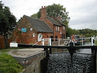
Broxtowe is a local government district with borough status in Nottinghamshire, England. It lies immediately west of the city of Nottingham, and most of the built-up areas of the borough form part of the Nottingham Urban Area. The council is based in Beeston and the borough also includes the towns of Eastwood, Kimberley and Stapleford and surrounding villages and rural areas.

<span class="mw-page-title-main">Nottingham Express Transit</span> Light-rail tramway in Nottingham, England

Nottingham Express Transit (NET) is a 20-mile (32 km) tram system in Nottingham, England.

<span class="mw-page-title-main">Sandiacre</span> Human settlement in England

Sandiacre is a town and civil parish in the borough of Erewash in Derbyshire,England adjoining the border with Nottinghamshire. The population of the parish was 8,889 at the 2011 Census.

<span class="mw-page-title-main">Chilwell</span> Village in Broxtowe, Nottinghamshire, England

Chilwell is a suburban area in the borough of Broxtowe in Nottinghamshire, England. It lies on the west side of the town of Beeston and is 4 miles (6.4 km) south-west of the centre of Nottingham.

<span class="mw-page-title-main">Broxtowe (UK Parliament constituency)</span> Parliamentary constituency in the United Kingdom, 1983 onwards

Broxtowe is a parliamentary constituency in Nottinghamshire, England, represented in the House of Commons of the UK Parliament since 2024 by Juliet Campbell, from the Labour Party.

<span class="mw-page-title-main">Stapleford, Nottinghamshire</span> Town and civil parish in Nottinghamshire, England

Stapleford is a town and civil parish in the Borough of Broxtowe, Nottinghamshire, England, 6 miles (9.7 km) west of Nottingham. The population of the civil parish at the 2001 census was 14,991, at the 2011 census it was 15,241, and 15,453 at the 2021 census.

<span class="mw-page-title-main">Attenborough, Nottinghamshire</span> Village in Nottinghamshire, England

Attenborough is a village in the Borough of Broxtowe in Nottinghamshire, England. It forms part of the Greater Nottingham area and is 4+12 miles (7.2 km) to the south-west of the city of Nottingham, between Long Eaton and Beeston. It adjoins the suburbs of Toton to the west and Chilwell to the north. The population of the ward, as at the 2011 Census, was 2,328.

<span class="mw-page-title-main">Bramcote</span> Suburban village in Nottinghamshire, England

Bramcote is a suburban village and former civil parish in the Broxtowe district of Nottinghamshire, England, between Stapleford and Beeston. It is in Broxtowe parliamentary constituency. The main Nottingham–Derby road today is the A52, Brian Clough Way. Nearby are Beeston, Wollaton, Chilwell and Stapleford. One of the main roads between Nottingham and Derby used to pass through the village centre, entering a cutting that formed a blind bend. A country house to the north of the village became publicly owned and was demolished in 1968. Its grounds became a public area of park and hillside, now known as Bramcote Hills Park.

<span class="mw-page-title-main">Broxtowe Wapentake</span>

Broxtowe was a wapentake of the ancient county of Nottinghamshire, England.

Broxtowe Borough Council elections are held every four years. Broxtowe Borough Council is the local authority for the non-metropolitan district of Borough of Broxtowe in Nottinghamshire, England. Since the full review of boundaries in 2015, 44 councillors are elected from 20 wards.

<span class="mw-page-title-main">Breaston</span> Human settlement in England

Breaston is a large village and civil parish in the Erewash district, in the south-east of Derbyshire and lies approximately 6.81 miles (10.96 km) east of the city of Derby and 8 miles (13 km) west of the city of Nottingham. The population of the civil parish as taken at the 2011 Census was 4,455. The settlement name Breaston means 'Braegd's farm/settlement': for a personal name and 'tūn' for either an enclosure, farmstead, village, etc.

<span class="mw-page-title-main">Transport in Nottingham</span> Overview of the transport network of Nottingham, England

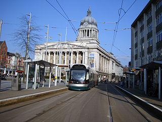
Nottingham is the seventh largest conurbation in the United Kingdom; despite this, the city's transport system was deemed to be poor for its size in the 1980s. In the early twenty-first century, the UK government invested heavily in the transport network of Nottingham, which has led to the re-opening of the Robin Hood Line and the construction of a light rail system, Nottingham Express Transit.

<span class="mw-page-title-main">East Midlands Hub railway station</span> Proposed station at Toton on the HS2 line under development

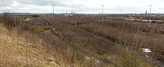
East Midlands Hub was a planned new railway station on the Leeds Branch of High Speed 2. It was intended to be located on the existing railway sidings in Toton, situated between Nottingham and Derby. The station would have been located adjacent to the M1 motorway in Nottinghamshire, on the border with Derbyshire.

<span class="mw-page-title-main">Toton Lane tram stop</span> Nottingham Express Transit tram stop

Toton Lane is a tram stop and park and ride site on the Nottingham Express Transit network, serving the suburb of Chilwell and town of Stapleford, Broxtowe in Nottinghamshire, England.

<span class="mw-page-title-main">John Frederick Dodd</span> English architect

John Frederick Dodd LRIBA was an architect based in Long Eaton, Derbyshire.

<span class="mw-page-title-main">2023 Broxtowe Borough Council election</span> 2023 English local election

The 2023 Broxtowe Borough Council election took place on 4 May 2023, to elect all 44 members of Broxtowe Borough Council in England. This took place as part of the 2023 United Kingdom local elections.

References

  1. "Towns and cities, characteristics of built-up areas, England and Wales". Census 2021. Offices for National Statistics. Retrieved 6 September 2023.
  2. Office for National Statistics Archived 6 January 2009 at the Wayback Machine
  3. "Broxtowe Ward population 2011". Neighbourhood Statistics. Office for National Statistics. Retrieved 16 April 2016.
  4. – Robert Mellors, Then and now series: Attenborough, Chilwell and Toton, 1920 [ permanent dead link ]
  5. "History of Toton, in Broxtowe and Nottinghamshire". A Vision of Britain through Time. Retrieved 6 August 2023.
  6. "Population statistics Toton Tn/CP through time". A Vision of Britain through Time . Retrieved 6 August 2023.
  7. "Relationships and changes Toton Tn/CP through time". A Vision of Britain through Time. Retrieved 6 August 2023.
  8. Local Government Act 1972
  9. "About Us - Toton Churches". Archived from the original on 18 June 2020. Retrieved 17 June 2020.
  10. "Stops in Toton". Bus Times. 2023. Retrieved 20 June 2023.
  11. "Nottsbus Connect". Nottinghamshire County Council. Retrieved 24 March 2020.
  12. "Download our timetable". Nottingham Express Transit. 2023. Retrieved 20 June 2023.
  13. Nottingham Express Transit Planning application
  14. "Timetables". East Midlands Railway. May 2023. Retrieved 20 June 2023.
  15. "Timetables". CrossCountry. 21 May 2023. Retrieved 20 June 2023.
  16. "Access to Toton, the HS2 East Midlands Hub" (PDF). Midlands Connect. 28 May 2020. Retrieved 28 May 2020.
  17. "HS2 rail extension to Leeds scrapped amid promise to transform rail". BBC News. 18 November 2021. Retrieved 20 June 2023.

Commons-logo.svg Media related to Toton at Wikimedia Commons