
The history of Turkmenistan traditionally began with the arrival of Indo-European Iranian tribes around 2000 BC. Early tribes were nomadic or semi-nomadic due to the arid conditions of the region, preventing widespread adoption of agriculture. The steppe culture in Central Asia was an extension of a larger Eurasian series of horse cultures which spanned the entire spectrum of language families, including the Indo-Europeans and Turko-Mongol groups. Some of the known early Iranian tribes included the Massagatae, the Scythians/Sakas, and early Soghdians, who were most likely precursors of the Khwarezmians. Turkmenistan was a passing point for numerous migrations and invasions by tribes, which gravitated towards the settled regions of the south, including ancient Mesopotamia, Elam, and the Indus Valley civilization.

Ashgabat or Asgabat, formerly named Poltoratsk between 1919 and 1927, is the capital and the largest city of Turkmenistan. It lies between the Karakum Desert and the Kopetdag mountain range in Central Asia, near the Iran-Turkmenistan border. The city has a population of 1,030,063.

Turkmenistan is a country in Central Asia bordered by Kazakhstan to the northwest, Uzbekistan to the north, east and northeast, Afghanistan to the southeast, Iran to the south and southwest and the Caspian Sea to the west. Ashgabat is the capital and largest city. It is one of the six independent Turkic states. With a population of 6.5 million, Turkmenistan is the 35th most-populous country in Asia and has the lowest population of the Central Asian republics while being one of the most sparsely populated nations on the Asian continent.

Merv, also known as the Merve Oasis, formerly known as Alexandria, Antiochia in Margiana and Marw al-Shāhijān, was a major Iranian city in Central Asia, on the historical Silk Road, near today's Mary, Turkmenistan. Human settlements on the site of Merv existed from the 3rd millennium BC until the 18th century AD. It changed hands repeatedly throughout history. Under the Achaemenid Empire, it was the center of the satrapy of Margiana. It was subsequently ruled by the ancient Macedonians, Seleucids, Parthians, Sasanians, Arabs, Ghaznavids, Seljuqs, Khwarazmians and Timurids, among others.

Ahal Region is one of five provinces of Turkmenistan. It is in the south-center of the country, bordering Iran and Afghanistan along the Kopet Dag Range. Its area is 97,160 km2 (37,510 sq mi) and population 886,845.
Daşoguz Region is one of the regions of Turkmenistan. It is in the north of the country, bordering Uzbekistan. The area of the province is 73,430 square kilometers, and the total population is 1,550,354. The capital is Daşoguz.

Mary Region is one of five provinces in Turkmenistan. It is located in the south-east of the country, bordering Afghanistan. Its capital is the city of Mary. Its area is 87,150 km2 (33,650 sq mi) and population 1,613,386. The average population density is about 15 persons per square kilometer, but it reaches 150–200 per square kilometer in the most developed oases.

Türkmenbaşy, formerly known as Krasnovodsk, Kyzyl-Su, and Shagadam, is a city in Balkan Province in western Turkmenistan, on the Türkmenbaşy Gulf of the Caspian Sea. It sits at an elevation of 27 metres. The population was 86,800, mostly ethnic Turkmens but also Russian, Armenian and Azeri minorities. As the terminus of the Trans-Caspian Railway and site of a major seaport on the Caspian, it is an important transportation center. The city is also the site of Turkmenistan's largest oil refining complex.

Mary, formerly named Merv, Meru and Alexandria Margiana, is a city on an oasis in the Karakum Desert in Turkmenistan, located on the Murgab River. It is the capital city of Mary Region. In 2010, Mary had a population of 126,000, up from 92,000 in the 1989 census. The ruins of the ancient city of Merv are located near the present-day city.

Nisa was an ancient settlement of the Parthians, located near the Bagyr neighborhood of Ashgabat, Turkmenistan, 18 km west of the city center. Nisa is described by some as the first seat of the Arsacid Empire. It is traditionally assumed to have been founded by Arsaces I and was reputedly the royal residence of the Parthian kings, although it has not been established that the fortress at Nisa was either a royal residence or a mausoleum.

Balkanabat, formerly Nebit-Dag and Neftedag, is the administrative centre of Balkan Province, the largest province in Turkmenistan. It lies at the foot of the Balkan Daglary mountain range. Balkanabat is about 450 km west of Ashgabat and 160 km east of the seaport city of Türkmenbaşy. The city layout is a grid of apartment blocks called kvartal (quarters). The main streets are Magtymguly, Pervomayskiy and Gurbansoltan eje şaýoly.

The Turkmen people have traditionally been nomads and equestrians, and even today after the fall of the USSR attempts to urbanize the Turkmens have not been very successful. They never really formed a coherent nation or ethnic group until they were forged into one by Joseph Stalin in the 1930s. Rather they are divided into clans, and each clan has its own dialect and style of dress. Turkmens are famous for making knotted Turkmen carpets, often mistakenly called "Bukhara rugs" in the West. These are elaborate and colorful hand-knotted carpets, and these too help indicate the distinctions among the various Turkmen clans.

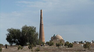
Konye-Urgench, also known as Old Urgench or Urganj, is a city of about 30,000 inhabitants in north Turkmenistan, just south from its border with Uzbekistan. It is the site of the ancient town of Gurgānj, which contains the ruins of the capital of Khwarazm. Its inhabitants deserted the town in the early eighteenth century in order to develop a new settlement, and Konye-Urgench has remained undisturbed ever since. In 2005, the ruins of Old Urgench were inscribed on the UNESCO List of World Heritage Sites.
Anau is a city in Turkmenistan. Until 20 December 2022 it was the capital of Ahal Province. It is situated 8 km southeast of Ashgabat, to which it is connected via the M37 highway.
Sarahs is an oasis city in Ahal Province, Turkmenistan, and the administrative center of Sarahs district. It is located at latitude 36°31' North; longitude 61°12' East and an elevation of 285m above sea level. It is one of the oases of the ancient Silk Road lying between Merv to the east and Mashhad to the west. In 1989 the city had a population of 9,585.

Darvaza is a rural council in Ak bugdaý District, Ahal Province, Turkmenistan of about 2 thousand inhabitants, located in the middle of the Karakum Desert, about 260 km north of Ashgabat. The rural council consists of three separate villages: Derweze, Ataguýy, and Böri.
The list of Turkmenistan-related articles is below

The Darvaza gas crater, also known as the Door to Hell or Gates of Hell, or, officially, the Shining of Karakum, is a burning natural gas field collapsed into a cavern near Darvaza, Turkmenistan. Hundreds of natural gas fires illuminate the floor and rim of the crater. The crater has been burning since the 1980s. How the crater formed is unknown, but engineers ignited the crater to prevent poisonous gases from spreading.

