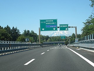
Italy has a well developed transport infrastructure. The Italian rail network is extensive, especially in the north, and it includes a high-speed rail network that joins the major cities of Italy from Naples through northern cities such as Milan and Turin. The Florence–Rome high-speed railway was the first high-speed line opened in Europe when more than half of it opened in 1977. Italy has 2,507 people and 12.46 km2 per kilometer of rail track, giving Italy the world's 13th largest rail network. The Italian rail network is operated by state-owned Ferrovie dello Stato, while the rail tracks and infrastructure are managed by Rete Ferroviaria Italiana.

A tram is a type of urban rail transit consisting of either individual railcars or self-propelled multiple unit trains that run on tramway tracks on urban public streets; some include segments on segregated right-of-way. The tramlines or tram networks operated as public transport are called tramways or simply trams/streetcars. Because of their close similarities, trams are commonly included in the wider term light rail, which also includes systems separated from other traffic.
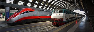
The Italian railway system is one of the most important parts of the infrastructure of Italy, with a total length of 24,567 km (15,265 mi) of which active lines are 16,832 km (10,459 mi). The network has recently grown with the construction of the new high-speed rail network. Italy is a member of the International Union of Railways (UIC). The UIC Country Code for Italy is 83.

Guided buses are buses capable of being steered by external means, usually on a dedicated track or roll way that excludes other traffic, permitting the maintenance of schedules even during rush hours. Unlike railbuses, trolleybuses or rubber-tyred trams, for part of their routes guided buses are able to share road space with general traffic along conventional roads, or with conventional buses on standard bus lanes.

Guided Light Transit was the name of guided bus technology and associated infrastructure designed and manufactured by Bombardier Transportation. It was installed in two French cities: Nancy and Caen. The Caen system was closed in 2017 and replaced by conventional trams, while the Nancy system was closed in March 2023 and is to be replaced by trolleybuses.

Translohr is a rubber-tyred tramway system, originally developed by Lohr Industrie of France and now run by a consortium of Alstom Transport and Fonds stratégique d'investissement (FSI) as newTL, which took over from Lohr in 2012. It is used in Paris and Clermont-Ferrand, France; Medellín, Colombia; and Venice-Mestre and Padua in Italy. In June 2012, Alstom Group and the Strategic Investment Fund acquired Translohr for €35 million.

The Caen guided light transit or Caen TVR, locally known as "the Tram", was an electrically powered guided bus system in Caen, France, which used Bombardier Guided Light Transit technology.

The Marseille Metro is a rapid transit system serving Marseille, France. The system comprises two lines, partly underground, serving 31 stations, with an overall route length of 22.7 kilometres (14.1 mi). Line 1 opened in 1977, followed by Line 2 in 1984. Two stations, Saint-Charles and Castellane, each provide interchange between lines.

A medium-capacity system (MCS), also known as light rapid transit or light metro, is a rail transport system with a capacity greater than light rail, but less than typical heavy-rail rapid transit. MCS trains are usually 1 to 4 cars. Most medium-capacity rail systems are automated or use light-rail type vehicles.
A rubber-tyred tram is a development of the guided bus in which a vehicle is guided by a fixed rail in the road surface and draws current from overhead electric wires.

Trams in France date from 1837 when a 15 km steam tram line connected Montrond-les-Bains and Montbrison in the Loire. With the development of electric trams at the end of the 19th century, networks proliferated in French cities over a period of 15 years. Although nearly all of the country's tram systems were replaced by bus services in the 1930s or shortly after the Second World War, France is now in the forefront of the revival of tramways and light rail systems around the globe. Only tram lines in Lille and Saint-Étienne have operated continuously since the 19th century; the Marseille tramway system ran continuously until 2004 and only closed then for 3 years for extensive refurbishment into a modern tram network. Since the opening of the Nantes tramway in 1985, more than twenty towns and cities across France have built new tram lines. As of 2024, there are 28 operational tram networks in France, with 3 more planned. France is also home to Alstom, a leading tram manufacturer.

The Dresden tramway network is a network of tramways forming the backbone of the public transport system in Dresden, a city in the federal state of Saxony, Germany. Opened in 1872, it has been operated since 1993 by Dresdner Verkehrsbetriebe (DVB), and is integrated in the Verkehrsverbund Oberelbe (VVO).
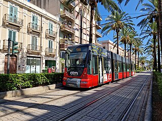
The Messina tramway is a tramway forming part of the public transport system in Messina, a city and comune in the region of Sicily, Italy.
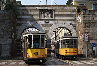
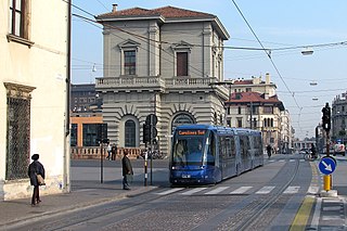
The Milan tramway network is part of the public transport network of Milan, Italy, operated by Azienda Trasporti Milanesi (ATM).

The Turin tramway network is an important part, along with the Turin Metro, of the public transport network of the city and comune of Turin, in the Piedmont region, northwest Italy.
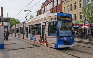
The Rostock tramway network is a network of tramways forming the centrepiece of the public transport system in Rostock, the largest city in the federal state of Mecklenburg-Vorpommern, Germany.
The Padua Tramway serves Padua, a city in Veneto in Northern Italy. In operation since 2007, it is 10.3 kilometres (6.4 mi) long, and comprises one line, linking the north with the south, calling at the main station and then passing the historic city centre.

The Essen tramway network is a 52.4-kilometer (32.6 mi) network of tramways forming part of the public transport system in Essen, a city in the federal state of North Rhine-Westphalia, Germany. Parts of the system also serve the neighbouring city of Gelsenkirchen.

The Halberstadt tramway network is a network of tramways forming part of the public transport system in Halberstadt, a city in the federal state of Saxony-Anhalt, Germany.


