San Bernardino County, officially the County of San Bernardino, is a county located in the southern portion of the U.S. state of California, and is located within the Inland Empire area. As of the 2020 U.S. Census, the population was 2,181,654, making it the fifth-most populous county in California and the 14th-most populous in the United States. The county seat is San Bernardino.

Greater Los Angeles is the second-largest metropolitan area in the United States, with a population of 18.5 million in 2021, encompassing six counties in Southern California extending from Ventura County in the west to San Bernardino County and Riverside County in the east, with Los Angeles County in the center, Kern County in the north, and Orange County to the southeast. The Los Angeles–Anaheim–Riverside combined statistical area covers 33,954 square miles (87,940 km2), making it the largest metropolitan region in the United States by land area. The contiguous urban area is 2,281 square miles (5,910 km2), the remainder mostly consisting of mountain and desert areas.
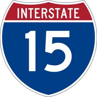
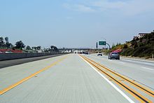
Interstate 15 (I-15) is a major Interstate Highway in the Western United States, running through Southern California and the Intermountain West. I-15 begins near the Mexican border in San Diego County and stretches north to Alberta, Canada, passing through the states of California, Nevada, Arizona, Utah, Idaho, and Montana. The Interstate serves the cities of San Diego, San Bernardino, Las Vegas, Salt Lake City, Idaho Falls, and Great Falls. It also passes close to the urban areas of Los Angeles, Orange, and Riverside counties, California. The stretches of I-15 in Idaho, Utah, and Arizona have been designated as the "Veterans Memorial Highway". The southern end is at a junction with I-8 and State Route 15 (SR 15) in San Diego, and the northern end is at a connection with Alberta Highway 4 at the Sweetgrass–Coutts Border Crossing.

State Route 91 (SR 91) is a major east–west state highway in the U.S. state of California that serves several regions of the Greater Los Angeles urban area. A freeway throughout its entire length, it officially runs from Vermont Avenue in Gardena, just west of the junction with the Harbor Freeway, east to Riverside at the junction with the Pomona and Moreno Valley freeways.

Interstate 215 (I-215) is a 54.5-mile-long (87.7 km) north–south auxiliary Interstate Highway in the Inland Empire region of the San Bernardino–Riverside urban area in Southern California. It has portions designated as the Barstow, Escondido, and Armed Forces Freeways. I-215 is a bypass auxiliary route of I-15, running from Murrieta to northern San Bernardino. While I-215 connects the city centers of both Riverside and San Bernardino, its parent I-15 runs to the west through Corona and Ontario.

The Pomona Valley is located in the Greater Los Angeles Area between the San Gabriel Valley and San Bernardino Valley in Southern California. The valley is approximately 30 miles (48 km) east of downtown Los Angeles.

The Cucamonga Valley is a region of southwestern San Bernardino County and northwestern Riverside County, in southern California. It is located below the San Gabriel Mountains in the Inland Empire region.

State Route 74, part of which forms the Palms to Pines Scenic Byway or Pines to Palms Highway, and the Ortega Highway, is a state highway in the U.S. state of California. It runs from Interstate 5 in San Juan Capistrano in Orange County to the city limits of Palm Desert in Riverside County. Stretching about 111 miles (179 km), it passes through several parks and National Forests between the Pacific coast and the Coachella Valley.

State Route 60 (SR 60) is an east–west state highway in the U.S. state of California. It serves the cities and communities on the eastern side of the Los Angeles metropolitan area and runs along the south side of the San Gabriel Valley. It functions as a bypass route of Interstate 10 (I-10) through the area between the East Los Angeles Interchange in Los Angeles and Beaumont. SR 60 provides a route across several spurs of the Peninsular Ranges, linking the Los Angeles Basin with the Pomona Valley and San Gabriel Valley. The highway also runs concurrently with SR 57 and I-215. Portions of SR 60 are designated as either the Pomona Freeway or the Moreno Valley Freeway.

The Southern California freeways are a vast network of interconnected freeways in the megaregion of Southern California, serving a population of 23 million people. The Master Plan of Metropolitan Los Angeles Freeways was adopted by the Regional Planning Commission in 1947 and construction began in the early 1950s. The plan hit opposition and funding limitations in the 1970s, and by 2004, only some 61% of the original planned network had been completed.

The Foothill Freeway is a freeway in the Los Angeles metropolitan area, California, United States, running from the Sylmar district of Los Angeles east to Redlands. The western segment is signed as Interstate 210 (I-210) from its western end at I-5 to SR 57 in Glendora, while the eastern segment is signed as State Route 210 (SR 210) to its eastern terminus at I-10. Under the California Streets and Highways Code, the entire Foothill Freeway is legally referred to as Route 210.

State Route 83, also or primarily known as Euclid Avenue, is a state highway and city street in the U.S. state of California. Officially, SR 83 runs from the Chino Valley Freeway in Chino Hills north to the San Bernardino Freeway in Upland. Euclid Avenue then continues north through Upland to the unincorporated community of San Antonio Heights.

The Morongo Basin is an endorheic basin and valley region located in eastern San Bernardino County, in Southern California.
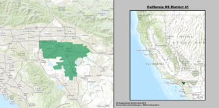
California's 41st congressional district is a congressional district in Riverside County, in the U.S. state of California. The district is currently represented by Republican Ken Calvert.

Route 15, consisting of the contiguous segments of State Route 15 (SR 15) and Interstate 15 (I-15), is a major north–south state highway and Interstate Highway in the U.S. state of California, connecting San Bernardino, Riverside, and San Diego Counties. The route consists of the southernmost 289.24 miles (465.49 km) of I-15, which extends north through Nevada, Arizona, Utah, Idaho, and Montana to the Canada–US border. It is a major thoroughfare for traffic between San Diego and the Inland Empire, as well as between Southern California, Las Vegas, Nevada, and the Intermountain West.

Greater Los Angeles has a complex multimodal transportation infrastructure, which serves as a regional, national and international hub for passenger and freight traffic. The transportation system of Greater Los Angeles includes the United States' largest port complex, seven commuter rail lines, Amtrak service, a subway system within the city of Los Angeles, and numerous highways. Los Angeles is integrated into the Interstate Highway System by Interstate 5, Interstate 10, and Interstate 15, along with numerous auxiliary highways and state routes. Bus service is also included locally within the area by numerous local government agencies. Subways and light commuter rail lines are present within Los Angeles proper, allowing mass transportation within the city. Commuter railroads are run by Metrolink. Amtrak has numerous railroad lines that connect Los Angeles to the rest of the country.


The Inland Empire is a metropolitan area or region inland of and adjacent to coastal Southern California, centering around the cities of San Bernardino and Riverside, and bordering Los Angeles County to the west. The bulk of the population is centered in the cities of northwestern Riverside County and southwestern San Bernardino County, and is sometimes considered to include the desert communities of the Coachella and Victor Valleys, respectively on the other sides of the San Gorgonio Pass and San Bernardino Mountains from the Santa Ana River watershed that forms the bulk of the Inland Empire; a much broader definition includes all of Riverside and San Bernardino counties. The combined land area of the counties of the Inland Empire is larger than ten U.S. states—West Virginia, Maryland, Hawaii, Massachusetts, Vermont, New Hampshire, New Jersey, Connecticut, Delaware and Rhode Island.