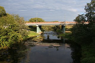
Istra is a river in Moscow Oblast, Russia.

Pushkinskaya Square or Pushkin Square in the Tverskoy District of central Moscow. It was historically known as Strastnaya Square, and renamed for Alexander Pushkin in 1937.

Robin Leonard Trower is an English rock guitarist and vocalist who achieved success with Procol Harum during the 1960s, and then again as the bandleader of his own power trio known as Robin Trower.
Pineview is a neighbourhood in Beacon Hill-Cyrville Ward in the east end of Ottawa, Ontario, Canada. Prior to amalgamation in 2001, the neighbourhood was part of the City of Gloucester. As of the Canada 2011 Census, the neighbourhood had a population of 6,163

Charleton is a civil parish in the English county of Devon. In 2001 its population was 511. The parish forms part of the Saltstone electoral ward. At the 2011 census the ward had a population of 1,529.
Quinze de Novembro is a municipality in the state of Rio Grande do Sul, Brazil.
William B. Trower Bayshore Natural Area Preserve is a Natural Area Preserve located in Northampton County, Virginia. A small preserve with no public facilities, it is located on the Chesapeake Bay, and contains beach strand and dune communities. It supports a population of the northeastern beach tiger beetle, as well as some scrubland and woodland areas.
Old Trower is an unincorporated community in Accomack County, Virginia.
Scott Glacier is a 15-mile-long (24 km) glacier located in the Chugach Mountains, near Cordova, Alaska. It begins at 60°44′31″N145°04′20″W and trends southwest to 60°37′11″N145°23′09″W, 13 miles (21 km) east northeast of Cordova. The Scott Glacier was named in 1908 after a "local miner".

Esquon is an unincorporated community in Butte County, California. It lies 3 miles (4.8 km) south-southeast of Durham on the Sacramento Northern Railroad, at an elevation of 135 feet.
Dixie Technical College is a public technical training institution located in St. George, Utah, and is part of the statewide Utah College of Applied Technology system. Dixie Tech was established on September 1, 2001 by the Utah State Legislature and currently offers certificate programs and a Pharmacy Technician program. Dixie Tech received its accreditation on June 26, 2007 from the Council on Occupational Education.
Fellaoucene is a town and commune in Tlemcen Province in northwestern Algeria.
Shah Verdi Kandi is a village in Sarajuy-ye Sharqi Rural District, Saraju District, Maragheh County, East Azerbaijan Province, Iran. At the 2006 census, its population was 171, in 29 families.
Dunkirk is an unincorporated community in Crawford County, Kansas, United States.
Lone Oak is an unincorporated community in Crawford County, Kansas, in the United States.
Tilsit is an unincorporated community in Cape Girardeau County, in the U.S. state of Missouri.
Big Creek is a stream in Shannon and Texas counties in the Ozarks of southern Missouri. It is a tributary of the Current River.

Philip Station is an unincorporated community in Marrs Township, Posey County, in the U.S. state of Indiana.
Starkville is a populated place in Wyoming County, Pennsylvania. It is the home of a bridge on the National Register of Historic Places.
Crane Ridge is a 6 mile long ridge of the Diablo Range in Alameda County, California. Crane Ridge runs southeast from the Livermore Valley toward Mount Wallace. Its highest point is at 2,939 feet / 895.8 meters.


