Related Research Articles

Kalamo Township is a general law township of Eaton County in the U.S. state of Michigan. The population was 1,742 at the 2000 census.

Henderson Township is a township in Huntingdon County, Pennsylvania, United States. The population was 933 at the 2010 census. The township includes the village of Ardenheim.

Heath Township is a township in Jefferson County, Pennsylvania, United States. The population was 124 at the 2010 census, down from 160 at the 2000 census. It was named for early Jefferson County settler Elijah Heath.

Mineral Township is a township in Venango County, Pennsylvania, United States. The population was 533 at the 2000 census.
Becknerville is an unincorporated town in southern Clark County, Kentucky, United States. It is part of the Lexington–Fayette Metropolitan Statistical Area.

San Jacinto High School is the only major public high school in the city of San Jacinto, California. The other high school in San Jacinto, Mountain View High School, is a small alternative school located near San Jacinto High's campus.
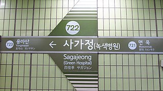
Sagajeong Station is a station on the Seoul Subway Line 7.
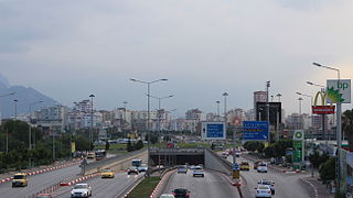
A roundabout interchange is a type of interchange between a controlled access highway, such as a motorway or freeway, and a minor road. The slip roads to and from the motorway carriageways converge at a single roundabout, which is grade-separated from the motorway lanes with bridges.
The Zoological Museum of the University of Athens is a museum in Athens, Greece.
Martins Siding is an unincorporated community in Northampton County, Virginia, United States. It is on the eastern shore of Virginia, on the Delmarva peninsula. A short drive away from Martins Siding is the Chesapeake Bay Bridge-Tunnel, which you can take over to the 'mainland'. The bridge begins in Kiptopeke.

Passira is a municipality in the state of Pernambuco, Brazil.
Scarlets Mill is an unincorporated community in Robeson Township, Berks County, Pennsylvania. The Twin Valley School District serves the village, whose zip code is 19508. Scarlets Mill is also located up Haycreek Road from the nearby village of Geigertown.
Greenwood, Bath County was an unincorporated community in Bath County, Virginia, in the United States. Greenwood was abandoned and later flooded due to the construction of Lake Moomaw.
Hotchkiss is an unincorporated community in Bath County, Virginia, in the United States.
Pea Hill Shores is an unincorporated community located in Brunswick County, in the U.S. state of Virginia.
Glennonville is an unincorporated community in Dunklin County, in the U.S. state of Missouri.
Ottery Creek is a stream in Iron and Reynolds counties in the U.S. state of Missouri. It is a tributary to the Middle Fork Black River.
Deer Creek is a stream in Polk County in the Ozarks of southwest Missouri. It is a tributary of the Pomme de Terre River.
Caney Creek is a stream in Scott County in southeast Missouri. The stream headwaters arise northwest of Benton at 37°06′16″N89°34′51″W. The stream flows east then turns to the northwest passing under U.S. Route 61 twice north of Benton. The stream flows west passing north of New Hamburg, under Missouri Route 77 and north of the community of Bleda and ends at 37°06′30″N89°43′31″W in the Old Caney Basin at Drainage ditch #1.
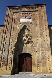
Niğde Alaaddin Mosque is a historical mosque in Niğde, Turkey.
References
- ↑ "Tunnels Mill". Geographic Names Information System . United States Geological Survey . Retrieved February 9, 2014.

Coordinates: 37°57′59″N75°34′51″W / 37.96639°N 75.58083°W
| | This Accomack County, Virginia state location article is a stub. You can help Wikipedia by expanding it. |