Related Research Articles

Bulpitt is a village in Christian County, Illinois, United States. The population was 222 at the 2010 census.

Sheridan Township is a civil township of Huron County in the U.S. state of Michigan. The population was 736 at the 2000 census.

Farnham is a village in the town of Brant, Erie County, New York, United States. The population of Farnham was 382 at the 2010 census. It is part of the Buffalo–Niagara Falls Metropolitan Statistical Area. The village is named after Leroy Farnham, a local landowner and merchant.

Heath Springs is a town in Lancaster County, South Carolina, United States. The population was 790 at the 2010 census.

Athol is a census-designated place (CDP) in the town of Athol in Worcester County, Massachusetts, United States. The population was 8,265 at the 2010 census.

Robin Leonard Trower is an English rock guitarist and vocalist who achieved success with Procol Harum throughout 1967–1971, and then again as the bandleader of his own power trio known as The Robin Trower Band.

Bridge of Sighs is the second solo album by the English guitarist and songwriter Robin Trower. Released in 1974, it was his second album after leaving Procol Harum, and was a commercial breakthrough for Trower. Songs such as "Bridge of Sighs", "Too Rolling Stoned", "Day of the Eagle" and "Little Bit of Sympathy" became live concert staples.

The Archaeological Museum of Granada is an archaeological museum in the Albayzín district, Granada, Spain, established in 1879.
The Castril palace is a Renaissance style palace located in Sacromonte, a district of the Spanish city of Granada. Nowadays it hosts the Archaeological Museum of Granada.

Blandinsville Township is located in McDonough County, Illinois. As of the 2010 census, its population was 846 and it contained 445 housing units.
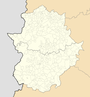
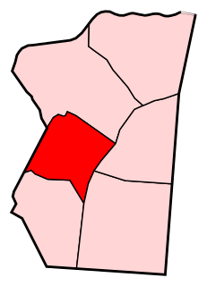
Burguillos del Cerro is a municipality in the province of Badajoz, Extremadura, Spain. It has a population of 3,284 and an area of 187.5 km².
William B. Trower Bayshore Natural Area Preserve is a Natural Area Preserve located in Northampton County, Virginia. A small preserve with no public facilities, it is located on the Chesapeake Bay, and contains beach strand and dune communities. It supports a population of the northeastern beach tiger beetle, as well as some scrubland and woodland areas.

Bellahøj is an area situated 5 kilometres to the northwest of central Copenhagen, Denmark. It features the Bellahøj Houses, a functionalist housing project, as well as parkland with an open-air theatre. The 37 metre high hill situated in Bellahøj Park is the highest point in Copenhagen. The area offers an extensive view over the skyline of Copenhagen.
Trower is an unincorporated community in Accomack County, Virginia.
Water Valley, New York is a hamlet in the town of Hamburg in Erie County, New York, United States.

Indian River is a 59.1-mile-long (95.1 km) tributary of the Manistique River on the Upper Peninsula of Michigan in the United States. It rises out of Hovey Lake at 46°17′36″N86°42′20″W on Hiawatha National Forest land in Alger County and flows south and east through a lake district and on through Schoolcraft County. The river flows into the 8,659 acre (35 km²) Indian Lake at 46°17′36″N86°42′20″W and flows out at 45°59′30″N86°17′15″W. It then flows east and south about 2.5 miles where it merges with the Manistique River, which then flows through Manistique and into Lake Michigan at 45°56′56″N86°14′45″W.

Clarence is a hamlet and census-designated place (CDP) within the town of Clarence in Erie County, New York, United States. The population was 2,646 at the 2010 census.

Valdeacederas is a ward (barrio) of Madrid belonging to the district of Tetuán.
Berruguete is a ward (barrio) of Madrid belonging to the district of Tetuán.
Ras Sedr massacre is a claimed mass murder of dozens of Egyptian prisoners of war that reportedly took place immediately after a paratrooper unit of Israel Defense Forces conquered Ras Sedr on 8 June 1967 during the Six-Day War, the same day as the USS Liberty incident.
References
- ↑ "Old Trower". Geographic Names Information System . United States Geological Survey . Retrieved February 9, 2014.

Coordinates: 37°35′30″N75°42′20″W / 37.59167°N 75.70556°W
| | This Accomack County, Virginia state location article is a stub. You can help Wikipedia by expanding it. |