Unionville, Ohio | |
|---|---|
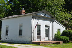 Connecticut Land Company Office | |
 Location of Unionville, Ohio | |
| Coordinates: 41°46′49″N81°00′10″W / 41.78028°N 81.00278°W | |
| Country | United States |
| State | Ohio |
| Counties | Ashtabula, Lake |
| Elevation | 742 ft (226 m) |
| Time zone | UTC-5 (Eastern (EST)) |
| • Summer (DST) | UTC-4 (EDT) |
| ZIP code | 44088 |
| Area code | 440 |
| GNIS feature ID | 1065411 [1] |
Unionville is an unincorporated community on the line between northwestern Harpersfield Township in Ashtabula County and eastern Madison Township in Lake County, in the U.S. state of Ohio. [1] It has a post office with the ZIP code 44088. [2] It lies along State Route 84.
The community's location where two counties meet caused the name "Union" to be selected. [3] Unionville is the site of the land office of the Connecticut Western Reserve; it is listed on the National Register of Historic Places. [4]