Andover, Ohio

Last updated

Andover, Ohio
Public Square, Andover, Ohio - 20230205.jpg
Downtown Andover
Motto: 
" Together For A Better Future "
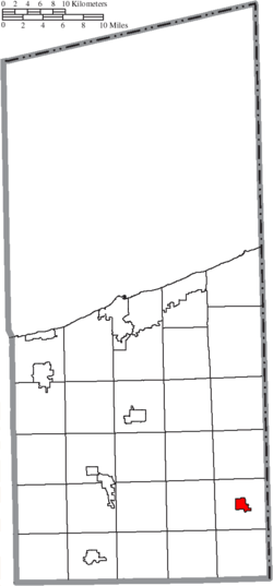
Map of Ashtabula County Ohio Highlighting Andover Village.png
Location of Andover in Ashtabula County
USA Ohio location map.svg
Red pog.svg
Andover, Ohio
Usa edcp location map.svg
Red pog.svg
Andover, Ohio
North America laea location map.svg
Red pog.svg
Andover, Ohio
Coordinates: 41°36′24″N80°34′20″W / 41.60667°N 80.57222°W / 41.60667; -80.57222
Country United States
State Ohio
County Ashtabula
Area
[1]
  Total1.41 sq mi (3.65 km2)
  Land1.41 sq mi (3.65 km2)
  Water0.00 sq mi (0.00 km2)
Elevation
[2]
1,093 ft (333 m)
Population
 (2020)
  Total972
  Density690.34/sq mi (266.49/km2)
Time zone UTC-5 (Eastern (EST))
  Summer (DST) UTC-4 (EDT)
ZIP code
44003
Area code 440
FIPS code 39-02050 [3]
GNIS feature ID1064328 [2]
Website http://www.andovervillage.com/

Andover is a village located in the south-east of Ashtabula County, Ohio, United States. The population was 972 at the time of the 2020 census.

Contents

History

David Lindsey, writing in 1955, observes that "New England Yankees, moving into Ohio's Western Reserve in 1798, brought with them the name Andover from a township in Tolland County, Connecticut, birthplace of many of the migrants. General Henry Champion, second largest shareholder in the Connecticut Land Company, first acquired Andover Township in the drawing for lands held at Hartford in 1798." [4] [5]

A post office named Sharon was established in 1815, and changed to Andover in 1826. [6]

Andover was incorporated in 1883.[ citation needed ]

Geography

According to the United States Census Bureau, the village has a total area of 1.37 square miles (3.55 km2), all land. [7]

Demographics

Historical population
CensusPop.Note
1890 733
1900 81511.2%
1910 90210.7%
1920 9212.1%
1930 906−1.6%
1940 9454.3%
1950 1,10216.6%
1960 1,1161.3%
1970 1,1795.6%
1980 1,2052.2%
1990 1,2160.9%
2000 1,2694.4%
2010 1,145−9.8%
2020 972−15.1%
U.S. Decennial Census [8]

2010 census

As of the census [9] of 2010, there were 1,145 people, 411 households, and 264 families living in the village. The population density was 835.8 inhabitants per square mile (322.7/km2). There were 469 housing units at an average density of 342.3 per square mile (132.2/km2). The racial makeup of the village was 95.5% White, 2.8% African American, 0.3% Native American, 0.1% Asian, and 1.4% from two or more races. Hispanic or Latino of any race were 1.7% of the population.

There were 411 households, of which 31.9% had children under the age of 18 living with them, 46.0% were married couples living together, 13.4% had a female householder with no husband present, 4.9% had a male householder with no wife present, and 35.8% were non-families. 30.7% of all households were made up of individuals, and 17% had someone living alone who was 65 years of age or older. The average household size was 2.44 and the average family size was 3.04.

The median age in the village was 44.2 years. 22.9% of residents were under the age of 18; 7.2% were between the ages of 18 and 24; 20.8% were from 25 to 44; 27.7% were from 45 to 64; and 21.4% were 65 years of age or older. The gender makeup of the village was 45.4% male and 54.6% female.

2000 census

As of the census [3] of 2000, there were 1,269 people, 427 households, and 271 families living in the village. The population density was 929.2 inhabitants per square mile (358.8/km2). There were 463 housing units at an average density of 339.0 per square mile (130.9/km2). The racial makeup of the village was 95.82% White, 3.07% African American, 0.32% from other races, and 0.79% from two or more races. Hispanic or Latino of any race were 1.18% of the population. 23.6% were of American, 14.9% German, 13.8% Irish, 9.4% English and 7.0% Italian ancestry according to Census 2000.

There were 427 households, out of which 34.4% had children under the age of 18 living with them, 51.1% were married couples living together, 9.4% had a female householder with no husband present, and 36.3% were non-families. 33.5% of all households were made up of individuals, and 21.1% had someone living alone who was 65 years of age or older. The average household size was 2.53 and the average family size was 3.27.

In the village, the population was spread out, with 25.0% under the age of 18, 5.6% from 18 to 24, 25.2% from 25 to 44, 22.5% from 45 to 64, and 21.7% who were 65 years of age or older. The median age was 40 years. For every 100 females there were 88.3 males. For every 100 females age 18 and over, there were 82.0 males.

The median income for a household in the village was $31,250, and the median income for a family was $45,526. Males had a median income of $31,845 versus $22,679 for females. The per capita income for the village was $14,702. About 8.2% of families and 10.7% of the population were below the poverty line, including 11.3% of those under age 18 and 20.7% of those age 65 or over.

Parks and recreation

Pymatuning Lake and Pymatuning State Park are located east of Andover.

John R. Overly Recreation Park in Andover features a playground, hiking/biking paths, picnic area, pavilion, ball field and volleyball court.

Education

The Pymatuning Valley School District operates elementary and high schools in Andover. In 2006, the district completed major renovations as the high school, middle school, and elementary school are now all located on the same campus just west of town.

Infrastructure

Andover police vehicle Andover Ohio Police Ford Interceptor Utility (37445987334).jpg
Andover police vehicle

Notable people

Related Research Articles

<span class="mw-page-title-main">Gordon, Ohio</span> Village in Ohio, United States

Gordon is a village in Darke County, Ohio, United States. The population was 245 at the 2020 census.

<span class="mw-page-title-main">Addyston, Ohio</span> Village in Ohio, United States

Addyston is a village in Miami Township, Hamilton County, Ohio, United States. Located along the Ohio River, it is a western suburb of the neighboring city of Cincinnati. The population was 927 at the 2020 census.

<span class="mw-page-title-main">Cleves, Ohio</span> City in Ohio, United States

Cleves is a village in Miami Township, Hamilton County, Ohio, United States. Located along the Ohio River, it is a western suburb of Cincinnati. The population was 3,414 at the 2020 census.

<span class="mw-page-title-main">Evendale, Ohio</span> Village in Ohio, United States

Evendale is a village in Hamilton County, Ohio, United States, within the Cincinnati metropolitan area. The population was 2,669 at the 2020 census.

<span class="mw-page-title-main">Hanover, Ohio</span> Village in Ohio, United States

Hanover is a village in Licking County, Ohio, United States. The population was 1,270 at the 2020 census. The village lies along Ohio State Route 16.

<span class="mw-page-title-main">Hebron, Ohio</span> Village in Ohio, USA

Hebron is a village in Licking County, Ohio, United States. The population was 2,326 at the 2020 census.

<span class="mw-page-title-main">Limaville, Ohio</span> Census-designated place in Ohio, United States

Limaville is a census-designated place (CDP) and former village in Stark County, Ohio, United States. The population was 151 at the 2020 census. It is part of the Canton–Massillon Metropolitan Statistical Area.

<span class="mw-page-title-main">Macksburg, Ohio</span> Village in Ohio, United States

Macksburg is a village in Washington County, Ohio, United States, along the West Fork of Duck Creek. The population was 120 at the 2020 census. The village is about 28 miles (45 km) south of Cambridge, Ohio.

<span class="mw-page-title-main">Conneaut Township, Crawford County, Pennsylvania</span> Township in Pennsylvania, United States

Conneaut Township is a township in Crawford County, Pennsylvania, United States. The population was 1,334 at the 2020 census.

<span class="mw-page-title-main">North Shenango Township, Pennsylvania</span> Township in Pennsylvania, United States

North Shenango Township is a township in Crawford County, Pennsylvania, United States. The population was 1,274 at the 2020 census, down from 1,410 at the 2010 census.

<span class="mw-page-title-main">Pymatuning Central, Pennsylvania</span> Census-designated place in Pennsylvania, United States

Pymatuning Central is a census-designated place (CDP) in Crawford County, Pennsylvania, United States. The population was 2,269 at the 2010 census.

<span class="mw-page-title-main">Pymatuning North, Pennsylvania</span> Census-designated place in Pennsylvania, United States

Pymatuning North is a census-designated place (CDP) in Crawford County, Pennsylvania, United States. The population was 311 at the 2010 census.

<span class="mw-page-title-main">Pymatuning South, Pennsylvania</span> Census-designated place in Pennsylvania, United States

Pymatuning South is a census-designated place (CDP) in Crawford County, Pennsylvania, United States. The population was 479 at the 2010 census.

<span class="mw-page-title-main">South Shenango Township, Pennsylvania</span> Township in Pennsylvania, United States

South Shenango Township is a township in Crawford County, Pennsylvania, United States. The population was 1,831 at the 2020 census, down from 2,037 at the 2010 census.

<span class="mw-page-title-main">West Shenango Township, Pennsylvania</span> Township in Pennsylvania, United States

West Shenango Township is a township in Crawford County, Pennsylvania, United States. The population was 435 at the 2020 census, down from 504 at the 2010 census.

<span class="mw-page-title-main">South Pymatuning Township, Pennsylvania</span> Township in Pennsylvania, United States

South Pymatuning Township is a township in Mercer County, Pennsylvania, United States. The population was 2,650 at the 2020 census, a decrease from 2,695 in 2010.

<span class="mw-page-title-main">Wilson, Ohio</span> Village in Ohio, United States

Wilson is a village in Belmont and Monroe counties in the U.S. state of Ohio. The population was 129 at the 2020 census. It is part of the Wheeling metropolitan area.

<span class="mw-page-title-main">Gratiot, Ohio</span> Village in Ohio, United States

Gratiot is a village in Licking and Muskingum counties in the U.S. state of Ohio. The population was 215 at the 2020 census.

Andover is a village located in the town of Andover in Allegany County, New York, United States. The population was 1,042 at the 2010 census. The name is derived from Andover, Vermont.

Andover is a town in Allegany County, New York, United States. The population was 1,634 at the 2020 census. The town is on the eastern edge of Allegany County and contains the village of Andover.

References

  1. "ArcGIS REST Services Directory". United States Census Bureau. Retrieved September 20, 2022.
  2. 1 2 U.S. Geological Survey Geographic Names Information System: Andover, Ohio
  3. 1 2 "U.S. Census website". United States Census Bureau . Retrieved January 31, 2008.
  4. Lindsey, David (1955). Ohio's Western Reserve; the story of its place names. Cleveland, Ohio: Western Reserve Historical Society.
  5. Overman, William Daniel (1958). Ohio Town Names. Akron, OH: Atlantic Press. p. 4.
  6. Gallagher, John S. and Patera, Alan H. (1979). The Post Offices of Ohio, p. 32, p. 34. Burtonsville, Maryland: The Depot.
  7. "US Gazetteer files 2010". United States Census Bureau. Archived from the original on January 25, 2012. Retrieved January 6, 2013.
  8. "Census of Population and Housing". Census.gov. Retrieved June 4, 2015.
  9. "U.S. Census website". United States Census Bureau . Retrieved January 6, 2013.