
Palakkad is one of the 14 districts in the Indian state of Kerala. It was carved out of the southeastern region of the former Malabar District on 1 January 1957. It is located at the central region of Kerala and is the second largest district in the state after Idukki. The city of Palakkad is the district headquarters. Palakkad is bordered on the northwest by the Malappuram district, on the southwest by the Thrissur district, on the northeast by Nilgiris district, and on the east by Coimbatore district of Tamil Nadu. The district is nicknamed "The granary of Kerala". Palakkad is the gateway to Kerala due to the presence of the Palakkad Gap, in the Western Ghats. The 2,383 m high Anginda peak, which is situated in the border of Palakkad district, Nilgiris district, and Malappuram district, in Silent Valley National Park, is the highest point of elevation in Palakkad district. Palakkad city is about 347 kilometres (216 mi) northeast of the state capital, Thiruvananthapuram.

Shoranur is a town and a municipality located in the Palakkad district, in the Indian state of Kerala, located on the banks of the Bharathapuzha River. The town covers an area of 32.28 km2.

Thiruvegappura is a village in Pattambi Taluk Palakkad district in the state of Kerala, India. It is administered by the Thiruvegapuram gram panchayat.
Vadakkencherry is a town and gram panchayat in the Palakkad district, state of Kerala, India. It is located about 35 km from Palakkad along National Highway 544. Vadakkencherry-Mannuthy section of NH-544 is the first six lane National Highway in the state.

Mannarkkad, formerly known as Mannarghat, is a major municipal town in Palakkad district of the Indian state of Kerala. The Silent Valley National Park and the Attappadi Reserve Forest are located in Mannarkkad Taluk. Mannarkkad is situated 36 km away from district headquarters Palakkad on National Highway 966.

Cherpulassery is a town and municipality in the Palakkad district, of Kerala, India. Cherpulassery is often called the Sabarimala of Malabar as the famous Ayyappankavu temple is located here. The Puthanalakkal Bhagavathi temple and the Kalavela and Pooram associated with it is one of the largest festivals in the region. The town is located about 43 km (27 mi) west of the district headquarters at Palakkad on State Highway 53. Cherpulassery is known among the football enthusiasts all across the state thanks to the football club Al Madeena Cherpulassery.

Kudallur is in the Palakkad district of Kerala. It is in Pattambi taluk, bordering Malappuram district, also on the banks of Bharathapuzha. The Bharathappuzha river separates Kudallur from Kuttippuram town in Malappuram district. Kudallur is a part of Thrithala and Ponnani.

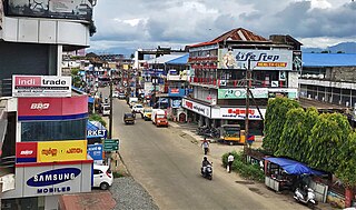
Chittur-Thathamangalam is a town and municipality in Palakkad district of Kerala State, India. It is the headquarters of Chittur taluk, 13 km (8.1 mi) south-east of Palakkad, on the banks of the Kannadipuzha, a major headstream of the Bharathapuzha, the second longest river in Kerala. A Mini Civil Station is also located here which provides government related services. It consists of two areas, Chittur and Thathamangalam which together form the municipality.
Cheriyamundam is a village and Grama Panchayat in Kerala, India. It covers an area of 11.95 km2 and includes 25,760 (1991) inhabitants. It lies near the Tirur River.

Koottanad is a town in Nagalassery Panchayath of Pattambi taluk of Palakkad district, in the state of Kerala. It is situated at the border of Thrissur, Palakkad and Malapuram districts. It is located 32 km from the Thrissur and 65 km from Palakkad, on the road between Guruvayoor and Palakkad. It is connected by road to other parts of Kerala and the nearest Railway station is Pattambi 9 km away. Bharathapuzha Nila Riverflows through Thrithala, 5 km away. The Pakkanar Memorial, a tribute to the Pariah saint of Parayi petta panthirukulam can be found at Thrithala. The Kattil Madam Temple, a small granite Buddhist monument on the Pattambi-Guruvayoor road, is of great archaeological importance. It is believed to date back to the 9th/10th century AD. The debris of a Fort can be seen behind Juma Mazjid, Koottanad between Koottanad and Chalissery Road.
Pulamanthole is a Panchayath in Malappuram district of Kerala, India. It is situated on the banks of Kunthippuzha. The river separates Malappuram and Palakkad districts, a new bridge has been built across it recently.

Lakkidi or Lakkidi Perur is a small village in Ottapalam Taluk of Palakkad district, Kerala, India. It is located 23 km west of Palakkad on the Palakkad - Pattambi Road. The nearest town is Ottapalam, which is 10 km away. Lakkidi is situated 303 km from the state capital, Thiruvananthapuram. The pin code of Lakkidi Post Office is 679301 and the STD code is 0466.
Edayoor is an Indian village.
Vallapuzha is a village and gram panchayat in Pattambi Taluk, Palakkad district in the state of Kerala, India. Vallpuzha Kalapoot (Bull-Race) is famous across Kerala.

Shoranur Junction is the railway station located at Shoranur, Palakkad District, Kerala. It comes under the Palakkad Railway Division of the Southern Railway. It is the largest railway station in the state of Kerala in terms of area. It is an important junction because it is the point at which the line from Chennai via Jolarpettai, Erode and Palakkad meets the coastal line from Mangalore to Kanyakumari. Further, Shoranur junction is the node from which a separate Branch line goes to the town of Nilambur, about 66 km to the north. The Nilambur–Shoranur line, which connects two tiny hill-towns, is one of the most picturesque in India.
Mezhathur is an Indian village in the state of Kerala situated at Pattambi taluk of Palakkad district at the border of Thrissur, Malappuram and Palakkad districts. It is a historical and cultural village in Kerala. It is known for traditional Ayurveda physicians like Chatharu Nair and Vaidyamadom Valiya Narayanan Namboodiri. It is also the native place of renowned writer and social reformer V. T. Bhattathiripad. It is also the Birth place of Renowned Sanskrit Scholar and Critic M.P. Sankunni Nair.
Kuruvattoor is a village in Palakkad district in the state of Kerala, India. The village shares its borders with Kailiyad, Mundakottukurussi, Vallappuzha and Kanayam. The village comes under Vallapuzha Panchayat, Pattambi block and Pattambi Taluk. The village is encouraging arts and sports, especially football. Many clubs and local bodies create events for boosting cultural aspects.

Ambalapara is a gram panchayat in the Palakkad district, state of Kerala, India. It is the local government organisation that serves the villages of Ambalapara-I and Ambalapara-II and forms a part of the Ottapalam taluk.

Mulleria is a small town located in Karadka Panchayath, Kasaragod district in Kerala, India.

Kalpathy or Kalpathi is a residential area in Palakkad city, Kerala, India. It is famous for the Viswanatha Swamy Temple, which is located along the banks of the Kalpathy river, one of the tributaries of the Bharathapuzha. Kalpathy is also famous for its agraharam, or traditional village. It is the first heritage village in Kerala. There are around 4 agraharams of Brahmins who migrated from Tamil Nadu so many years ago to Kalpathy. Many temples, other than the Viswanatha Swamy Temple, are also present here. The annual festival Kalpathy Ratholsavam is held here, with chariots as the main attraction. Kalpathy and it's neighbourhoods have witnessed large settlements of people in colonies and apartments, making it one of the major residential areas of the city.

