Wallace, Nebraska

Last updated

Wallace, Nebraska
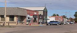
Wallace, Nebraska downtown 1.jpg
Downtown Wallace
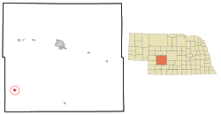
Lincoln County Nebraska Incorporated and Unincorporated areas Wallace Highlighted.svg
Location of Wallace, Nebraska
Coordinates: 40°50′19″N101°9′52″W / 40.83861°N 101.16444°W / 40.83861; -101.16444
Country United States
State Nebraska
County Lincoln
Area
[1]
  Total0.71 sq mi (1.84 km2)
  Land0.71 sq mi (1.84 km2)
  Water0.00 sq mi (0.00 km2)
Elevation
3,110 ft (948 m)
Population
 (2020)
  Total318
  Density447.26/sq mi (172.58/km2)
Time zone UTC-6 (Central (CST))
  Summer (DST) UTC-5 (CDT)
ZIP code
69169
Area code 308
FIPS code 31-51175 [2]
GNIS feature ID0834434 [3]

Wallace is a village in Lincoln County, Nebraska, United States. It is part of the North Platte, Nebraska Micropolitan Statistical Area. The population was 366 at the 2010 census.

Contents

History

When the railroad was extended in 1887 Wallace was platted. [4]

Geography

Wallace is located at 40°50′19″N101°9′52″W / 40.83861°N 101.16444°W / 40.83861; -101.16444 (40.838672, -101.164365). [5]

According to the United States Census Bureau, the village has a total area of 0.71 square miles (1.84 km2), all land. [6]

Climate

Climate data for Wallace 2W, Nebraska (1991–2020 normals, extremes 1962–present)
MonthJanFebMarAprMayJunJulAugSepOctNovDecYear
Record high °F (°C)75
(24)
78
(26)
89
(32)
94
(34)
101
(38)
109
(43)
110
(43)
108
(42)
106
(41)
94
(34)
85
(29)
82
(28)
110
(43)
Mean maximum °F (°C)61.7
(16.5)
66.7
(19.3)
78.2
(25.7)
85.3
(29.6)
91.9
(33.3)
98.1
(36.7)
101.7
(38.7)
98.9
(37.2)
95.7
(35.4)
87.0
(30.6)
74.6
(23.7)
63.8
(17.7)
103.1
(39.5)
Average high °F (°C)39.3
(4.1)
42.2
(5.7)
52.9
(11.6)
61.5
(16.4)
71.5
(21.9)
83.2
(28.4)
89.0
(31.7)
86.8
(30.4)
79.0
(26.1)
65.3
(18.5)
51.5
(10.8)
41.0
(5.0)
63.6
(17.6)
Daily mean °F (°C)26.2
(−3.2)
28.7
(−1.8)
38.1
(3.4)
46.7
(8.2)
57.9
(14.4)
69.1
(20.6)
74.6
(23.7)
72.2
(22.3)
63.2
(17.3)
49.6
(9.8)
37.2
(2.9)
27.6
(−2.4)
49.3
(9.6)
Average low °F (°C)13.0
(−10.6)
15.2
(−9.3)
25.3
(−3.7)
32.0
(0.0)
44.2
(6.8)
55.1
(12.8)
60.3
(15.7)
57.5
(14.2)
47.3
(8.5)
33.8
(1.0)
22.9
(−5.1)
14.2
(−9.9)
34.9
(1.6)
Mean minimum °F (°C)−7.3
(−21.8)
−4.4
(−20.2)
5.1
(−14.9)
18.1
(−7.7)
29.9
(−1.2)
43.8
(6.6)
50.8
(10.4)
47.9
(8.8)
34.1
(1.2)
18.3
(−7.6)
6.6
(−14.1)
−3.7
(−19.8)
−13.5
(−25.3)
Record low °F (°C)−26
(−32)
−28
(−33)
−19
(−28)
3
(−16)
19
(−7)
31
(−1)
40
(4)
35
(2)
15
(−9)
0
(−18)
−20
(−29)
−33
(−36)
−33
(−36)
Average precipitation inches (mm)0.30
(7.6)
0.56
(14)
0.88
(22)
2.22
(56)
3.47
(88)
3.83
(97)
3.24
(82)
2.65
(67)
1.56
(40)
1.66
(42)
0.51
(13)
0.49
(12)
21.37
(543)
Average snowfall inches (cm)3.4
(8.6)
5.6
(14)
3.1
(7.9)
3.2
(8.1)
0.1
(0.25)
0.0
(0.0)
0.0
(0.0)
0.0
(0.0)
0.0
(0.0)
1.5
(3.8)
2.4
(6.1)
2.7
(6.9)
22.0
(56)
Average precipitation days (≥ 0.01 in)2.94.05.27.710.39.68.16.85.55.73.23.072.0
Average snowy days (≥ 0.1 in)2.43.12.41.40.10.00.00.00.00.71.62.314.0
Source: NOAA [7] [8]

Demographics

Historical population
CensusPop.Note
1900 130
1910 17534.6%
1920 32786.9%
1930 40624.2%
1940 335−17.5%
1950 3617.8%
1960 293−18.8%
1970 241−17.7%
1980 34944.8%
1990 308−11.7%
2000 3296.8%
2010 36611.2%
2020 318−13.1%
U.S. Decennial Census [9]

2010 census

As of the census [10] of 2010, there were 366 people, 140 households, and 104 families residing in the village. The population density was 515.5 inhabitants per square mile (199.0/km2). There were 152 housing units at an average density of 214.1 per square mile (82.7/km2). The racial makeup of the village was 85.5% White, 1.1% Native American, 0.8% Asian, 10.4% from other races, and 2.2% from two or more races. Hispanic or Latino of any race were 17.2% of the population.

There were 140 households, of which 40.7% had children under the age of 18 living with them, 61.4% were married couples living together, 7.1% had a female householder with no husband present, 5.7% had a male householder with no wife present, and 25.7% were non-families. 22.1% of all households were made up of individuals, and 10% had someone living alone who was 65 years of age or older. The average household size was 2.61 and the average family size was 3.09.

The median age in the village was 35.8 years. 30.9% of residents were under the age of 18; 5.2% were between the ages of 18 and 24; 23.2% were from 25 to 44; 24.8% were from 45 to 64; and 15.8% were 65 years of age or older. The gender makeup of the village was 47.0% male and 53.0% female.

2000 census

As of the census [2] of 2000, there were 329 people, 134 households, and 97 families residing in the village. The population density was 467.5 inhabitants per square mile (180.5/km2). There were 145 housing units at an average density of 206.0 per square mile (79.5/km2). The racial makeup of the village was 99.39% White, 0.30% Native American, 0.30% from other races. Hispanic or Latino of any race were 0.61% of the population.

There were 134 households, out of which 32.8% had children under the age of 18 living with them, 64.2% were married couples living together, 3.7% had a female householder with no husband present, and 26.9% were non-families. 26.1% of all households were made up of individuals, and 11.9% had someone living alone who was 65 years of age or older. The average household size was 2.46 and the average family size was 2.95.

In the village, the population was spread out, with 28.9% under the age of 18, 4.6% from 18 to 24, 22.2% from 25 to 44, 24.3% from 45 to 64, and 20.1% who were 65 years of age or older. The median age was 42 years. For every 100 females, there were 86.9 males. For every 100 females age 18 and over, there were 98.3 males.

As of 2000 the median income for a household in the village was $36,771, and the median income for a family was $41,346. Males had a median income of $30,179 versus $19,688 for females. The per capita income for the village was $22,033. About 6.4% of families and 9.5% of the population were below the poverty line, including 18.3% of those under age 18 and none of those age 65 or over.
Local business

Related Research Articles

<span class="mw-page-title-main">Green Valley, Solano County, California</span> Census-designated place in California, United States

Green Valley is a census-designated place (CDP) located in Solano County, California, United States. It sits in the northeast corner of the San Francisco Bay Area and is located approximately 45 miles (72 km) from Sacramento, approximately 38 miles (61 km) from San Francisco, approximately 32 miles (51 km) from Oakland, less than 15 miles (24 km) from Napa Valley, and less than 15 miles (24 km) from both the Carquinez Bridge and the Benicia Bridge.

<span class="mw-page-title-main">Dongola, Illinois</span> Village in Illinois, United States

Dongola is a village in Union County, Illinois, United States. The population was 726 at the 2010 census.

<span class="mw-page-title-main">West Burlington, Iowa</span> City in Iowa, United States

West Burlington is a city in Des Moines County, Iowa, United States, adjacent to the Mississippi River city of Burlington. The population was 2,968 at the 2010 census. It is part of the Burlington, IA–IL Micropolitan Statistical Area.

<span class="mw-page-title-main">Veazie, Maine</span> Town in the state of Maine, United States

Veazie is a town in Penobscot County, Maine, United States. The population was 1,814 at the 2020 census. The town is named after General Samuel Veazie, an early lumber baron and railroad operator. Veazie was originally part of Bangor, using Penobscot River water power to operate sawmills. It became a separate town in 1853 because Gen. Veazie, its wealthiest citizen, thought Bangor's property taxes were too high.

<span class="mw-page-title-main">Grantwood Village, Missouri</span> Town in Missouri, United States

Grantwood Village is a town in St. Louis County, Missouri, United States. The population was 863 at the 2010 census.

<span class="mw-page-title-main">Greenwood, Nebraska</span> Village in Nebraska, United States

Greenwood is a village in northwest Cass County, Nebraska, United States. The population was 595 at the 2020 census.

<span class="mw-page-title-main">Waterloo, Nebraska</span> Village in Douglas County, Nebraska, United States

Waterloo is a village in Douglas County, Nebraska, United States. The population was 935 at the 2020 census.

<span class="mw-page-title-main">Pingree, North Dakota</span> City in North Dakota, United States

Pingree is a city in Stutsman County, North Dakota, United States. The population was 41 at the 2020 census. Pingree was founded in 1882.

<span class="mw-page-title-main">Felicity, Ohio</span> Village in Ohio, United States

Felicity is a village in Franklin Township, Clermont County, Ohio, United States. The population was 651 at the 2020 census.

<span class="mw-page-title-main">Limaville, Ohio</span> Census-designated place in Ohio, United States

Limaville is a census-designated place (CDP) and former village in Stark County, Ohio, United States. The population was 151 at the 2010 census. It is part of the Canton–Massillon Metropolitan Statistical Area.

<span class="mw-page-title-main">Wilmot, Ohio</span> Village in Ohio, United States

Wilmot is a village in southwestern Stark County, Ohio, United States. The population was 282 at the 2020 census. It is part of the Canton–Massillon metropolitan area.

<span class="mw-page-title-main">Harpster, Ohio</span> Village in Ohio, United States

Harpster is a village in Wyandot County, Ohio, United States. The population was 204 at the 2010 census.

<span class="mw-page-title-main">Agar, South Dakota</span> Town in South Dakota, United States

Agar is a small town in Sully County, South Dakota, United States. The population was 76 as of the 2010 census. Agar is a farm/ranch service center.

<span class="mw-page-title-main">Oliver, Wisconsin</span> Village in Wisconsin, United States

Oliver is a village in Douglas County, Wisconsin, United States. The population was 423 at the 2020 census.

<span class="mw-page-title-main">Poplar, Wisconsin</span> Village in Wisconsin, United States

Poplar is a village in Douglas County, Wisconsin, United States. The population was 603 at the 2010 census.

<span class="mw-page-title-main">Lannon, Wisconsin</span> Village in Wisconsin, United States

Lannon is a village in Waukesha County, Wisconsin, United States. The population was 1,355 at the 2020 census. Lannon is a part of the Milwaukee metropolitan area.

<span class="mw-page-title-main">Millington, Maryland</span> Town in Maryland, United States

Millington is a town in Kent and Queen Anne's counties in the U.S. state of Maryland. The population was 642 at the 2010 census. Millington is the head of navigation for the Chester River.

Northwest St. Louis is an unorganized territory in Saint Louis County, Minnesota, United States. The population was 306 at the 2000 census.

Muscoda is a town in Grant County, Wisconsin, United States. The population was 674 at the 2000 census. The Village of Muscoda is located partially within the town.

<span class="mw-page-title-main">Aniwa (town), Wisconsin</span>

Aniwa is a town in Shawano County, Wisconsin, United States. The population was 586 at the 2000 census. The Village of Aniwa is located within the town.

References

  1. "ArcGIS REST Services Directory". United States Census Bureau. Retrieved September 18, 2022.
  2. 1 2 "U.S. Census website". United States Census Bureau . Retrieved January 31, 2008.
  3. "US Board on Geographic Names". United States Geological Survey. October 25, 2007. Retrieved January 31, 2008.
  4. "Wallace, Lincoln County". Center for Advanced Land Management Information Technologies. University of Nebraska. Retrieved August 19, 2014.
  5. "US Gazetteer files: 2010, 2000, and 1990". United States Census Bureau. February 12, 2011. Retrieved April 23, 2011.
  6. "US Gazetteer files 2010". United States Census Bureau . Retrieved June 24, 2012.
  7. "NOWData - NOAA Online Weather Data". National Oceanic and Atmospheric Administration. Retrieved December 10, 2021.
  8. "Station: Wallace 2W, NE". U.S. Climate Normals 2020: U.S. Monthly Climate Normals (1991-2020). National Oceanic and Atmospheric Administration. Retrieved December 10, 2021.
  9. "Census of Population and Housing". Census.gov. Retrieved June 4, 2015.
  10. "U.S. Census website". United States Census Bureau . Retrieved June 24, 2012.
  11. "1st State Bank Locations". 1st.BANK. 2019.