Walnut Cove, North Carolina

Last updated

Walnut Cove, North Carolina
Walnut Cove, North Carolina.jpg
North Main Street in Walnut Cove
Nickname: 
The Cove
NCMap-doton-WalnutCove.PNG
Location of Walnut Cove, North Carolina
Coordinates: 36°17′38″N80°08′27″W / 36.29389°N 80.14083°W / 36.29389; -80.14083
Country United States
State North Carolina
County Stokes
Founded1883
Incorporated1889
Named for A grove of walnut trees [1]
Government
  Type Mayor-Council
   Mayor Nellie Brown
Area
[2]
  Total2.56 sq mi (6.62 km2)
  Land2.52 sq mi (6.53 km2)
  Water0.03 sq mi (0.09 km2)
Elevation
[3]
646 ft (197 m)
Population
 (2020)
  Total1,586
  Density628.87/sq mi (242.78/km2)
Time zone UTC-5 (Eastern (EST))
  Summer (DST) UTC-4 (EDT)
ZIP code
27052
Area code 336
FIPS code 37-70780 [4]
GNIS feature ID2406826 [3]
Website www.townofwalnutcove.org

Walnut Cove is a town in Stokes County, North Carolina, United States. The population was 1,536 at the 2020 census. [5]

Contents

It is the home of the Walnut Cove Springfest, which draws many visitors to the area. Festival-organizers marked 1889, the town's incorporation date, but the town's roots date to the mid-18th century when it was known as Town Fork. Town Fork settlers formed a bond with Moravians in Bethania and Bethabara. Eventually, William Lash, a Moravian settler at Bethania, bought land along the Town Fork Creek, which later developed into a large plantation named Walnut Cove. The Town was a railroad center in its former years, and today remnants of the old Train Depot still stand on Depot Street.

It is also home to historic Covington House (built in 1821), Fulp-Marshall Home (built in 1836), Culler Roller Mill now known as Monitor Roller Mill (built in 1900).

Walnut Cove is also home to South Stokes High School, a big part of the town is located to the west of town, near NC 8 and Hawkins Road. Belews Lake and Hanging Rock State Park are located nearby. Winston-Salem is 23 miles (37 km) to the southeast via US 311, US 158 and Salem Parkway (US 421). Danbury is 10 miles (16 km) to the north via NC 89. Germanton is 6.6 miles to the west-southwest via NC 65. Madison and Mayodan are 14 miles (23 km) to the northeast via US 311. Other nearby cities include Kernersville, Walkertown, Rural Hall, Stokesdale, and the small community of Pine Hall.

History

The Christ Episcopal Church and Walnut Cove Colored School are listed on the National Register of Historic Places. [6]

Burt Myers, a race car driver for NASCAR Whelen Southern Modified Tour, is from Walnut Cove.

Geography

According to the United States Census Bureau, the town has a total area of 2.4 square miles (6.2 km2), all of it land.

Demographics

Historical population
CensusPop.Note
1890 320
1900 3365.0%
1910 48042.9%
1920 65135.6%
1930 1,08166.1%
1940 1,0840.3%
1950 1,1324.4%
1960 1,28813.8%
1970 1,213−5.8%
1980 1,147−5.4%
1990 1,088−5.1%
2000 1,46534.7%
2010 1,425−2.7%
2020 1,5367.8%
2021 (est.)1,532 [5] −0.3%
U.S. Decennial Census [7]

2020 census

Walnut Cove racial composition [8]
RaceNumberPercentage
White (non-Hispanic)1,08368.28%
Black or African American (non-Hispanic)35822.57%
Native American 90.57%
Asian 30.19%
Pacific Islander 10.06%
Other/Mixed 855.36%
Hispanic or Latino 472.96%

As of the 2020 United States census, there were 1,586 people, 802 households, and 493 families residing in the town.

2000 census

As of the census [4] of 2000, there were 1,465 people, 585 households, and 374 families residing in the town. The population density was 608.5 inhabitants per square mile (234.9/km2). There were 636 housing units at an average density of 264.2 per square mile (102.0/km2). The racial makeup of the town was 79.39% White, 19.11% African American, 0.14% Native American, 0.14% Asian, 0.34% from other races, and 0.89% from two or more races. Hispanic or Latino of any race were 0.96% of the population.

There were 585 households, out of which 26.7% had children under the age of 18 living with them, 46.2% were married couples living together, 15.6% had a female householder with no husband present, and 35.9% were non-families. 32.6% of all households were made up of individuals, and 15.9% had someone living alone who was 65 years of age or older. The average household size was 2.24 and the average family size was 2.83.

In the town, the population was spread out, with 19.5% under the age of 18, 6.3% from 18 to 24, 24.6% from 25 to 44, 22.8% from 45 to 64, and 26.8% who were 65 years of age or older. The median age was 45 years. For every 100 females, there were 80.0 males. For every 100 females age 18 and over, there were 73.1 males.

The median income for a household in the town was $31,944, and the median income for a family was $41,250. Males had a median income of $31,953 versus $24,871 for females. The per capita income for the town was $16,117. About 8.3% of families and 12.5% of the population were below the poverty line, including 10.0% of those under age 18 and 17.8% of those age 65 or over.

Related Research Articles

<span class="mw-page-title-main">Stokes County, North Carolina</span> County in North Carolina, United States

Stokes County is a county located in the U.S. state of North Carolina. As of the 2020 census, the population was 44,520. Its county seat is Danbury.

<span class="mw-page-title-main">Pitt County, North Carolina</span> County in North Carolina, United States

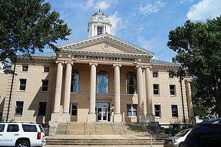
Pitt County is a county located in the Inner Banks region of the U.S. state of North Carolina. As of the 2020 census, the population was 170,243, making it the 14th-most populous county in North Carolina. Its county seat is Greenville.

<span class="mw-page-title-main">Madison County, North Carolina</span> County in North Carolina, United States

Madison County is a county located in the U.S. state of North Carolina. As of the 2020 census, the population was 21,193. Its county seat is Marshall. Madison County is part of the Asheville, NC Metropolitan Statistical Area.

<span class="mw-page-title-main">Forsyth County, North Carolina</span> County in North Carolina, United States

Forsyth County is located in the northwest Piedmont of the U.S. state of North Carolina. As of the 2020 census, the population was 382,590, making it the fourth-most populous county in North Carolina. Its county seat is Winston-Salem. Forsyth County is part of the Winston-Salem, NC, Metropolitan Statistical Area, which is also included in the Greensboro–Winston-Salem–High Point, NC, Combined Statistical Area. Portions of Forsyth County are in the Yadkin Valley wine region.

<span class="mw-page-title-main">Ashe County, North Carolina</span> County in North Carolina, United States

Ashe County is a county located in the U.S. state of North Carolina. As of the 2020 census, the population was 26,577. Its county seat is Jefferson.

<span class="mw-page-title-main">Leake County, Mississippi</span> County in Mississippi, United States

Leake County is a county in the center of the U.S. state of Mississippi. As of the 2020 census, the population was 21,275. Its county seat is Carthage. The county is named for Walter Leake, the Governor of Mississippi from 1822 to 1825.

<span class="mw-page-title-main">Beaver Cove, Maine</span> Town in the state of Maine, United States

Beaver Cove is a town in Piscataquis County, Maine, United States. The population was 133 at the 2020 census.

<span class="mw-page-title-main">Bethania, North Carolina</span> Town in North Carolina, United States

Bethania is the oldest municipality in Forsyth County, North Carolina, United States, and was most recently incorporated in 1995, upon the reactivation of the original 1838/1839 town charter. In 2009, Bethania celebrated the 250th anniversary of its establishment in 1759. As of the 2020 census, the town population was 341.

<span class="mw-page-title-main">Stokesdale, North Carolina</span> Town in North Carolina, United States

Stokesdale is a town in Guilford County, North Carolina, United States with small parts in the counties of Rockingham, Forsyth, and Stokes. The population was 5,924 at the 2020 census. Belews Lake is located nearby, and North Carolina Highway 68 and North Carolina Highway 65 both intersect U.S. Route 158 near the town's center.

Newton Grove is a town in Sampson County, North Carolina, United States. It was chartered in 1879. The population was 585 at the 2020 census.

<span class="mw-page-title-main">Danbury, North Carolina</span> City in North Carolina, United States

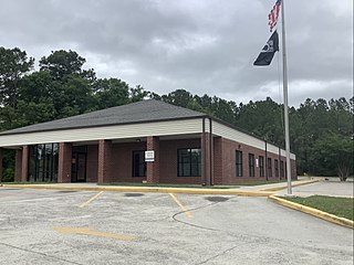
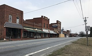
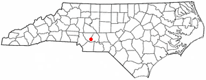
Danbury is a city located in Danbury Township, Stokes County, North Carolina, United States. As of the 2020 census, the city had a total population of 142. It is the county seat of Stokes County. Danbury is located on North Carolina Highway 8/89 approximately 20 miles (32 km) north of Winston-Salem and is the "Gateway to Hanging Rock". The Stokes County Government Center, Arts Council, school board, county jail, a public library, a post office, and other public services are found within the town limits. LifeBrite Community Hospital of Stokes is located about a half mile northwest of the town. North Stokes High School, a big part of town, is located 7.4 miles to the northwest.

<span class="mw-page-title-main">Wingate, North Carolina</span> Town in North Carolina, United States

Wingate is a town in Union County, North Carolina, United States. The population was 3,491 at the 2010 census.

<span class="mw-page-title-main">Moravian Falls, North Carolina</span> CDP in North Carolina, United States

Moravian Falls is a census-designated place (CDP) in Wilkes County, North Carolina, United States. The population was 1,712 as of the 2020 census.

<span class="mw-page-title-main">Jacksboro, Tennessee</span> Town in Tennessee, United States

Jacksboro is a town in Campbell County, Tennessee, United States. The population was 2,306 at the 2020 census. It is the county seat of Campbell County.

Walnut Hill is a census-designated place (CDP) in Sullivan County, Tennessee. The population was 2,394 at the 2010 census. It is part of the Kingsport-Bristol-Bristol, TN-VA Metropolitan Statistical Area, which is a component of the Johnson City-Kingsport-Bristol, TN-VA Combined Statistical Area, commonly known as the "Tri-Cities" region.

<span class="mw-page-title-main">Sand Fork, West Virginia</span> Town in West Virginia, United States

Sand Fork is a town in Gilmer County, West Virginia, United States. The population was 182 at the 2020 census. It is located along the Little Kanawha River, at the mouth of the Sand Fork.

<span class="mw-page-title-main">West Milford, West Virginia</span> Town in West Virginia, United States

West Milford is a town in Harrison County, West Virginia, United States. The population was 452 at the 2020 census.

<span class="mw-page-title-main">Northfork, West Virginia</span> Town in West Virginia, United States

Northfork is a town in McDowell County, West Virginia, United States, located on U.S. Route 52 between Welch and Bluefield.

<span class="mw-page-title-main">Angelica, Wisconsin</span> Town in Wisconsin, United States

Angelica is a town in Shawano County, Wisconsin, United States. The population was 1,635 at the 2000 census. The unincorporated communities of Angelica, Frazer Corners, Krakow, and Zachow are located partially in the town.

<span class="mw-page-title-main">Waldoboro (CDP), Maine</span> Census-designated place in Maine, United States

Waldoboro is a census-designated place (CDP) comprising the central village in the town of Waldoboro in Lincoln County, Maine, United States. The population was 1,300 at the 2020 census, out of 5,075 people in the entire town of Waldoboro.

References

  1. "North Carolina Gazetteer" . Retrieved November 24, 2023.
  2. "ArcGIS REST Services Directory". United States Census Bureau. Retrieved September 20, 2022.
  3. 1 2 U.S. Geological Survey Geographic Names Information System: Walnut Cove, North Carolina
  4. 1 2 "U.S. Census website". United States Census Bureau . Retrieved January 31, 2008.
  5. 1 2 Bureau, US Census. "City and Town Population Totals: 2020-2021". Census.gov. US Census Bureau. Retrieved July 9, 2022.
  6. "National Register Information System". National Register of Historic Places . National Park Service. July 9, 2010.
  7. "Census of Population and Housing". Census.gov. Retrieved June 4, 2016.
  8. "Explore Census Data". data.census.gov. Retrieved December 21, 2021.