Wasud Akola

Last updated

Akola (Wasud)
Village
Temple photoAkola.jpg
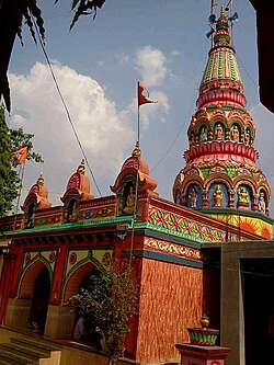
Siddhanath Temple, Akola
Country India
State Maharashtra
Government
Population
 (2011)
  Total5,421
Pincode
413307

Akola (Wasud) is a small village in Sangole taluka, Solapur district, (Maharashtra), India.

Related Research Articles

<span class="mw-page-title-main">Akola</span> City in Maharashtra, India

Akola is a municipal corporation and the third largest city in Vidarbha after Nagpur and Amravati and tenth largest city in Maharashtra. is located about 580 kilometres (360 mi) east of the state capital, Mumbai, and 250 kilometres (160 mi) west of the second capital, Nagpur. Akola is the administrative headquarters of the Akola district located in the Amravati division, and is governed by the Akola Municipal Corporation.

<span class="mw-page-title-main">Washim district</span> District of Maharashtra in India

Washim district is a district in Maharashtra, India. The headquarters is at Washim. The area of the district is 5,150 km2 (1,990 sq mi).

The Vaan River is a river of central India. It is tributary of Purna River, which is major tributary of Tapti River. It is also spelled as Wan or Van. It is also known as Waanganga.

<span class="mw-page-title-main">Akola district</span> District of Maharashtra in India

Akola district is a district in the Indian state of Maharashtra. The city of Akola is the district headquarters. Akola district forms the central part of Amravati Division, which was the former British Raj Berar Province.

Government Medical College, Akola is a medical college in Akola city. The attached teaching hospital - Survopchar Rugnalaya was previously known as Main Hospital. It is situated near the Ashok Vaatika square. The institution provides health care services to underprivileged population of four districts surrounding Akola.

Akola Airport is an airport located in Akola in the Indian state of Maharashtra. The airport can currently said to be non-functional for public use, as of now no public airplane services are available in Akola.It is natively called as Dr. Panjabrao Deshmukh Domestic Airport named after first State Agriculture Minister of India.

<span class="mw-page-title-main">Akola Fort</span> Fort in Akola district, Maharashtra, India

Akola fort along with the Narnala and Akot forts forms the major fortifications of the Akola district, Maharashtra, India.

Akola West Assembly constituency is one of the 288 Vidhan Sabha constituencies of Maharashtra state in western India. This constituency is located in the Akola district.

Risod Assembly constituency is one of the 288 constituencies of Maharashtra Vidhan Sabha and one of the three which are located in the Washim district.

Murtizapur Assembly constituency is one of the 288 constituencies of Maharashtra Vidhan Sabha and one of the five which are located in the Akola district. It is reserved for a Scheduled Caste candidate.

Akot Assembly constituency is one of the 288 constituencies of Maharashtra Vidhan Sabha and one of the five which are located in the Akola district.

Akola East Assembly constituency is one of the 288 constituencies of Maharashtra Vidhan Sabha and one of the five which are located in the Akola district.

Balapur Assembly constituency is one of the 288 constituencies of Maharashtra State Assembly and one of the five which are located in Akola district.

Akola Junction serves Akola in Akola district in the Indian state of Maharashtra. It is an important junction station on the Howrah–Nagpur–Mumbai line. There is a 5 ft 6 in broad gauge line to Secunderabad railway station and the metre-gauge Akola–Khandwa line is under gauge conversion.

The Rau railway station is one of the local railway stations in Rau, a suburb of Indore.

<span class="mw-page-title-main">National Highway 53 (India)</span> National highway in India

National Highway 53, combination of old, & is a national highway in India. It connects Hajira in Gujarat and Paradeep port in Odisha. NH-53 traverses the states of Gujarat, Maharashtra, Chhattisgarh and Odisha in India. The road is the part of AH46 network in India and it is officially listed as running over 1949 km (1211 mi) from Kolkata to Surat. it is also known as Surat - Kolkata Highway. It passes through Maharashtra, Chhattisgarh and Odisha states.

<span class="mw-page-title-main">National Highway 161 (India)</span> National highway in India

National Highway 161,, is a National Highway in India running through the states of Maharashtra and Telangana of India. The National Highway 161 joins the cities of Akola, Washim, Hingoli, Nanded, Degloor, Bichkunda, Pitlam, Narayana Khed,Shankarampet(A), Jogipet, Sanga Reddy.

Ajanti railway station is a small railway station in Khandwa district, Madhya Pradesh. Its code is ANI. It serves Ajanti village. The station consists of a single platform. The platform is not well sheltered. It lacks many facilities including water and sanitation. In 2015, gauge conversion started on this line. After conversion it will connect Indore to South India.

<span class="mw-page-title-main">Akola–Ratlam line</span> Railway route in India

The Akola–Ratlam rail line is a railway line in India linking Akola in Maharashtra with Ratlam in Madhya Pradesh.

National Highway 161A, commonly as NH 161A, is a National Highway running through states of Karnataka and Maharashtra, with a total length 507 Kilometres that connects Akot, Maharashtra to Bidar, Karnataka. National Highway 161A joins the cities of Akot, Akola, Barshitakli, Mangrulpir, Manora, Digras, Arni, Mahur, Kinwat, Himayatnagar, Mudkhed, Waghala, Mukhed, Maharashtra–Karnataka border in central southern India with each other. It is an auxiliary route of National Highway 61.

References