
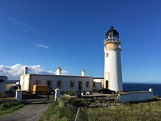
Corsewall Lighthouse is a lighthouse at Corsewall Point, Kirkcolm near Stranraer in the region of Dumfries and Galloway in Scotland. First lit in 1817, it overlooks the North Channel of the Irish Sea. The definition of the name Corsewall is the place or well of the Cross.

The Mull of Galloway is the southernmost point of Scotland. It is situated in Wigtownshire, Dumfries and Galloway, at the end of the Rhins of Galloway peninsula.
Holborn Head is a headland on the north-facing Atlantic coast of Caithness, in the Highland area of Scotland. The point of Holborn Head is at 58°37′23″N03°32′06″W. It has a lighthouse at its south end and the remains of an old fort at its tip.

Duncansby Head is the most northeasterly part of both the Scottish and British mainlands, slightly northeast of John o' Groats. It lies approximately 20 km (12 mi) east-southeast of Dunnet Head, the northernmost point of both the Scottish and British mainlands. Duncansby Head is in Caithness, Highland, in north-eastern Scotland. The headland juts into the North Sea, with the Pentland Firth to its north and west and the Moray Firth to its south.
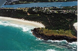
Fingal Head is a village on the Tasman Sea coast in the far northeast of New South Wales, Australia, about 5 km south of the New South Wales and Queensland border. The village is often just called Fingal. The headland and the small off-shore Island were first sighted by James Cook about 17:00 on 16 May 1770. At the time of the 2021 census, Fingal Head had a population of 592 people.

Cape Wrath Lighthouse at Cape Wrath was built in 1828 by Robert Stevenson and was manned until 1998, when it was converted to automatic operation by the Northern Lighthouse Board. It is located at the most North-Westerly point on the British mainland, in the traditional county of Sutherland within Highland Region. Durness is the closest village, 10 miles (16 km) to the south-east with Inverness around 120 miles (190 km) to the south.

Noup Head Lighthouse lies on the north west headland of the isle of Westray, in Orkney, Scotland. It was constructed by David A Stevenson in 1898 for the Northern Lighthouse Board.

Covesea Skerries Lighthouse, originally belonging to the Northern Lighthouse Board (NLB), is built on top of a small headland on the south coast of the Moray Firth at Covesea, near Lossiemouth, Moray, Scotland.

Fife Ness is a headland forming the most eastern point in Fife, Scotland. Anciently the area was called Muck Ross, which is a corruption of the Scottish Gaelic Muc-Rois meaning "Headland of the Pigs". It is situated in the area of Fife known as the East Neuk, and forms the muzzle of the dog-like outline of the latter when viewed on a map. Ness is a Scots word meaning "headland".

Rattray Head, historically Rattray Point, is a headland in Buchan, Aberdeenshire, on the north-east coast Scotland. To north lies Strathbeg Bay and Rattray Bay is to its south. The dunes at Rattray Head beach can be up to 75 feet (23 m) high and stretch 17 miles (27 km) from St Combs to Peterhead.

Shillay is the westernmost of the Monach Islands (Heisgeir), off North Uist in the Outer Hebrides.
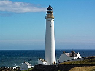
Scurdie Ness is a headland located on the South side of the River South Esk estuary, Montrose, Angus, Scotland. The River leads from the North Sea into Montrose Harbour and then into Montrose Basin. The headland has also been referred to as Scurdy Ness, Montrose point or Montroseness. The word Scurdie is a local word for the volcanic rock found there and Ness means a promontory, cape or headland. The coastline from Scurdie Ness to Rickle Craig has been designated a Site of Special Scientific Interest.

Rua Reidh Lighthouse stands close to the entrance to Loch Ewe in Wester Ross, Scotland.

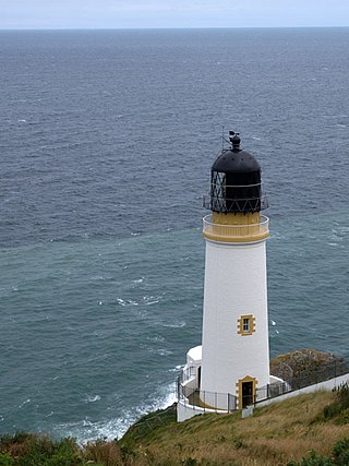
Ardnamurchan Lighthouse is a listed 19th century lighthouse, located on Ardnamurchan Point in Lochaber part of the Highland council area of Scotland. The lighthouse with its 36-metre-tall (118 ft), pink granite tower was completed in 1849 to a design by Alan Stevenson. It is the only lighthouse in the UK built in the Egyptian style. Mains electricity was installed in 1976, the light was automated in 1988 and is now operated remotely by the Northern Lighthouse Board from Edinburgh.

Neist Point Lighthouse is a lighthouse located on Neist Point on the Isle of Skye in Scotland. It was designed by David Alan Stevenson and was first lit on 1 November 1909. An aerial cableway is used to take supplies to the lighthouse and cottages.

Vaternish Lighthouse was built on Waternish Point in 1924. The engineers were David and Charles Stevenson. The original lens was donated to the Museum of Scottish Lighthouses.

Barra Head Lighthouse on Barra Head identifies the southern entrance to The Minch, roughly halfway between the Eilean Glas and Rinns of Islay lighthouses. The 58-foot (18-metre) stone tower, built in 1833, stands on the west side of the island, at the top of a very steep cliff, making the light the highest in the UK with a focal plane of 208 m (682 ft) above sea level. It has a range of 18 nautical miles. There is no shallow water west of Berneray to break the blow of the Atlantic storms and small fish are sometimes thrown onto the grass on the cliff top. In 1836 Sir Archibald Geikie recorded the movement of a 42-long-ton (43-tonne) block of gneiss across 5 feet (1.5 m) of ground during a violent storm.
The Tiumpan Head Lighthouse is an active lighthouse located in Tiumpan Head, Isle of Lewis, Outer Hebrides, Scotland.
Maughold Head Lighthouse is an active 20th century lighthouse, located on the headland of the same name at the southern end of Ramsey Bay on the eastern coast of the Isle of Man. Completed in 1914, it was designed by David A and Charles Stevenson.

Blackhead Lighthouse is a listed lighthouse built at the turn of the 20th century, near Whitehead in County Antrim, Northern Ireland. It marks the very northern end of Belfast Lough where it opens out into the North Channel that separates Northern Ireland and Scotland. The active lighthouse is managed by the Commissioners of Irish Lights, where it is named as the Blackhead Antrim Lighthouse to distinguish it from the more modern Blackhead lighthouse in County Clare.

