Westport, Oklahoma

Last updated

Westport, Oklahoma
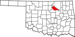
Pawnee County Oklahoma Incorporated and Unincorporated areas Westport highlighted.svg
Location of Westport, Oklahoma
Coordinates: 36°11′39″N96°20′11″W / 36.19417°N 96.33639°W / 36.19417; -96.33639
Country United States
State Oklahoma
County Pawnee
Area
[1]
  Total8.66 sq mi (22.44 km2)
  Land4.36 sq mi (11.29 km2)
  Water4.30 sq mi (11.15 km2)
Elevation
[2]
764 ft (233 m)
Population
 (2020)
  Total448
  Density102.82/sq mi (39.70/km2)
Time zone UTC-6 (Central (CST))
  Summer (DST) UTC-5 (CDT)
ZIP code
74020
Area code(s) 539/918
FIPS code 40-80250 [3]
GNIS feature ID2413474 [2]

Westport is a town in Pawnee County, Oklahoma, United States. The population was 448 as of the 2020 Census, [4] a 50.3% increase over the figure of 298 at the 2010 census, which was itself a gain of 12.9% over the figure of 264 reported in 2000. [5]

Contents

History

The city is much newer than most towns in northeast Oklahoma. It was incorporated in the mid 1960s, after completion of Lake Keystone. Most of the residences were built between 1960 and 1979. Its first Federal census reported 146 residents in 1970. The census population previously peaked at 325 in 1990, then dropped to 264 in 2000, perhaps because of major damage inflicted by an F4 tornado that occurred as part of the April 26, 1991 tornado outbreak. Both subsequent censuses have reported gains. Over 96 percent of the employed residents commuted to work in Stillwater or Tulsa. [6]

Geography

According to the United States Census Bureau, the town has a total area of 8.4 square miles (22 km2), of which 4.0 square miles (10 km2) is land and 4.5 square miles (12 km2) (52.78%) is water.

Demographics

Historical population
CensusPop.Note
1970 146
1980 26581.5%
1990 32623.0%
2000 264−19.0%
2010 29812.9%
2020 44850.3%
U.S. Decennial Census [7]

As of the census [3] of 2000, there were 264 people, 99 households, and 82 families residing in the town. The population density was 66.1 inhabitants per square mile (25.5/km2). There were 109 housing units at an average density of 27.3 per square mile (10.5/km2). The racial makeup of the town was 87.88% White, 0.76% African American, 3.03% Native American, 0.76% Asian, and 7.58% from two or more races. Hispanic or Latino of any race were 1.89% of the population.

There were 99 households, out of which 29.3% had children under the age of 18 living with them, 80.8% were married couples living together, 2.0% had a female householder with no husband present, and 16.2% were non-families. 12.1% of all households were made up of individuals, and 6.1% had someone living alone who was 65 years of age or older. The average household size was 2.67 and the average family size was 2.86.

In the town, the population was spread out, with 22.0% under the age of 18, 8.7% from 18 to 24, 20.8% from 25 to 44, 36.4% from 45 to 64, and 12.1% who were 65 years of age or older. The median age was 44 years. For every 100 females, there were 91.3 males. For every 100 females age 18 and over, there were 92.5 males.

The median income for a household in the town was $54,250, and the median income for a family was $64,375. Males had a median income of $36,667 versus $32,083 for females. The per capita income for the town was $23,345. About 4.3% of families and 6.8% of the population were below the poverty line, including none of those under the age of eighteen and 15.6% of those 65 or over.

Related Research Articles

<span class="mw-page-title-main">Westport, Minnesota</span> City in Minnesota, United States

Westport is a city in Pope County, Minnesota, United States. The population was 44 at the 2020 census.

<span class="mw-page-title-main">Pantego, North Carolina</span> Town in North Carolina, United States

Pantego is a town in Beaufort County, North Carolina, United States. The population was 179 at the 2010 Census.

<span class="mw-page-title-main">Tushka, Oklahoma</span> Town in Oklahoma, United States

Tushka is a town in Atoka County, Oklahoma, United States. The population was 413 as of the 2020 Census, a 32.4% increase over the 312 reported at the 2010 census.

<span class="mw-page-title-main">Canton, Oklahoma</span> Town in Oklahoma, United States

Canton is a town in Blaine County, Oklahoma, United States. The population was 625 at the 2010 census.

<span class="mw-page-title-main">Hendrix, Oklahoma</span> Town in Oklahoma, United States

Hendrix is a town in Bryan County, Oklahoma, United States. The population was 79 at both the 2010 and the 2000 censuses. According to the Bryan County Genealogy Society, Hendrix was originally known as Kemp City. This led to it often being confused with the neighboring town that is simply named Kemp. Hendrix was largely destroyed by a 1916 tornado.

<span class="mw-page-title-main">Union City, Oklahoma</span> Town in Oklahoma, United States

Union City is a town in Canadian County, Oklahoma, United States. The population was 1,645 at the 2010 census, a 19.6 percent increase from 1,375 in 2000. It is part of the Oklahoma City metropolitan statistical area.

<span class="mw-page-title-main">Sawyer, Oklahoma</span> Town in Oklahoma, United States

Sawyer is a town in Choctaw County, Oklahoma, United States. The population was 321 at the 2010 census.

<span class="mw-page-title-main">Twin Oaks, Oklahoma</span> Census-designated place in Oklahoma, United States

Twin Oaks is an unincorporated community and census-designated place (CDP) in Delaware County, Oklahoma, United States. The population was 198 at the 2010 census. A tornado hit the town on March 12, 2006, destroying 36 homes and damaging 31 others. 8 people were injured.

<span class="mw-page-title-main">Leedey, Oklahoma</span> Town in Oklahoma, United States

Leedey is a town in Dewey County, Oklahoma, United States. The population was 415 at the 2020 census.

<span class="mw-page-title-main">Alex, Oklahoma</span> Town in Oklahoma, United States

Alex is a town in Grady County, Oklahoma, United States. The population was 482 at the 2020 census.

<span class="mw-page-title-main">Rock Island, Oklahoma</span> Town in Oklahoma, United States

Rock Island is a town in Le Flore County, Oklahoma, United States. It is part of the Fort Smith, Arkansas-Oklahoma Metropolitan Statistical Area. The population was 646 at the 2010 census, a decline of 8.9 percent from the figure of 709 recorded in 2000.

<span class="mw-page-title-main">Carney, Oklahoma</span> Town in Oklahoma, United States

Carney is a town in Lincoln County, Oklahoma, United States. As of the 2020 census, the population of the town was 545.

<span class="mw-page-title-main">Cole, Oklahoma</span> Town in Oklahoma, United States

Cole is a town in McClain County, Oklahoma, United States. The population was 624 at the 2020 census, up from 555 at the 2010 census.

<span class="mw-page-title-main">Red Rock, Oklahoma</span> Town in Oklahoma, United States

Red Rock is a town in northern Noble County, Oklahoma, United States. The population was 283 at the 2010 census, a decline from 293 at the 2000 census. The headquarters of the Otoe-Missouria Tribe of Indians is located in Red Rock.

<span class="mw-page-title-main">Francis, Oklahoma</span> Town in Oklahoma, United States

Francis is a town in Pontotoc County, Oklahoma, United States. The population was 332 at the 2000 census.

<span class="mw-page-title-main">Bethel Acres, Oklahoma</span> Town in Oklahoma, United States

Bethel Acres is a town in Pottawatomie County, Oklahoma, United States. The population was 2,895 at the time of the 2010 census, an increase of 5.9 percent from the figure of 2,735 in 2000. It is primarily a bedroom community for people who work in the three nearby larger cities of Shawnee, Tecumseh and Oklahoma City.

<span class="mw-page-title-main">Earlsboro, Oklahoma</span> Town in Oklahoma, United States

Earlsboro is a town in Pottawatomie County, Oklahoma, United States. The population was 594 by the 2020 United States census. It was once called "...the town that whisky built and oil broke."

<span class="mw-page-title-main">Spencer, South Dakota</span> City in South Dakota, United States

Spencer is a city in McCook County, South Dakota, United States. The population was 136 at the 2020 census. The city was almost destroyed by a violent F4 tornado on May 30, 1998 which killed six people.

<span class="mw-page-title-main">Woonsocket, South Dakota</span> City in South Dakota, United States

Woonsocket is a city in Sanborn County, South Dakota. The population was 631 at the 2020 census. It is the county seat of Sanborn County.

<span class="mw-page-title-main">Black Earth, Wisconsin</span> Village in Wisconsin, United States

Black Earth is a village in Dane County, Wisconsin, United States. The population was 1,338 at the 2010 census. The village is located within the Town of Black Earth. It is part of the Madison Metropolitan Statistical Area.

References

  1. "ArcGIS REST Services Directory". United States Census Bureau. Retrieved September 20, 2022.
  2. 1 2 U.S. Geological Survey Geographic Names Information System: Westport, Oklahoma
  3. 1 2 "U.S. Census website". United States Census Bureau . Retrieved January 31, 2008.
  4. "Westport (town), Oklahoma". United States Census Bureau. Retrieved July 4, 2024.
  5. CensusViewer: Population of the City of Westport, Oklahoma. Retrieved March 21, 2012.
  6. Wilson, Linda D. Encyclopedia of Oklahoma History and Culture. "Westport." Retrieved May 18, 2012.
  7. "Census of Population and Housing". Census.gov. Retrieved June 4, 2015.