Hallett, Oklahoma

Last updated

Hallett, Oklahoma
Pawnee County Oklahoma Incorporated and Unincorporated areas Hallet highlighted.svg
Location of Hallett, Oklahoma
Coordinates: 36°13′55″N96°34′04″W / 36.23194°N 96.56778°W / 36.23194; -96.56778
Country United States
State Oklahoma
County Pawnee
Area
[1]
  Total0.92 sq mi (2.38 km2)
  Land0.92 sq mi (2.38 km2)
  Water0.00 sq mi (0.00 km2)
Elevation
[2]
922 ft (281 m)
Population
 (2020)
  Total105
  Density114.13/sq mi (44.07/km2)
Time zone UTC-6 (Central (CST))
  Summer (DST) UTC-5 (CDT)
ZIP code
74034
Area code(s) 539/918
FIPS code 40-32050 [3]
GNIS feature ID2412720 [2]

Hallett is a town in Pawnee County, Oklahoma, United States. It is located 19 miles southeast of Pawnee, the county seat of Pawnee County, on State Highway 99, slightly north of U.S. Highway 412. [4] The population was 125 at the 2010 census, a 25.6 percent decline from the figure of 168 recorded in 2000. [5]

Contents

History

The town of Hallett was founded on December 8, 1904, at the junction of the Arkansas Valley and Western Railway (later the St. Louis and San Francisco Railway) and the Missouri, Kansas and Oklahoma Railroad (later the Missouri, Kansas and Texas Railway). The developer, Hallett Townsite Company, was named for Charles H. Hallett, an officer in the Nineteenth Kansas Cavalry. A post office was established in the town on May 19, 1905, and the first newspaper, the weekly Hallett Herald was published. [4]

Hallett became a trade center for the local agriculture industry. The discovery of Hallett oil field brought a brief boom in 1908 and again in the 1920s. Population peaked at 279 in 1920, then declined to a low of 120 in 1950. [4]

An explosion at the Aerlex Fireworks plant killed 21 people on June 25, 1985. [4]

Hallett, Oklahoma Hallett cornet band.jpg
Hallett, Oklahoma

Geography

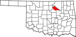
According to the United States Census Bureau, the town has a total area of 0.9 square miles (2.3 km2), all land. It is approximately 19 miles (31 km) southeast of the city of Pawnee. [4]

Demographics

Historical population
CensusPop.Note
1910 147
1920 27989.8%
1930 176−36.9%
1940 159−9.7%
1950 120−24.5%
1960 13210.0%
1970 125−5.3%
1980 18648.8%
1990 159−14.5%
2000 1685.7%
2010 125−25.6%
2020 105−16.0%
U.S. Decennial Census [6]

As of the census [3] of 2000, there were 168 people, 58 households, and 46 families residing in the town. The population density was 192.4 inhabitants per square mile (74.3/km2). There were 68 housing units at an average density of 77.9 per square mile (30.1/km2). The racial makeup of the town was 79.17% White, 8.33% Native American, and 12.50% from two or more races. Hispanic or Latino of any race were 1.79% of the population.

There were 58 households, out of which 29.3% had children under the age of 18 living with them, 63.8% were married couples living together, 10.3% had a female householder with no husband present, and 19.0% were non-families. 13.8% of all households were made up of individuals, and 6.9% had someone living alone who was 65 years of age or older. The average household size was 2.90 and the average family size was 3.23.

In the town, the population was spread out, with 32.1% under the age of 18, 8.9% from 18 to 24, 24.4% from 25 to 44, 20.2% from 45 to 64, and 14.3% who were 65 years of age or older. The median age was 33 years. For every 100 females, there were 88.8 males. For every 100 females age 18 and over, there were 93.2 males.

The median income for a household in the town was $30,000, and the median income for a family was $30,250. Males had a median income of $41,250 versus $51,250 for females. The per capita income for the town was $12,539. About 15.6% of families and 14.1% of the population were below the poverty line, including 18.8% of those under the age of eighteen and 23.5% of those 65 or over.

Related Research Articles

<span class="mw-page-title-main">Pawnee County, Oklahoma</span> County in Oklahoma, United States

Pawnee County is a county located in the U.S. state of Oklahoma. As of the 2020 census, the population was 15,553. Its county seat is Pawnee. The county is named after the Pawnee Nation, whose reservation used to encompass the county prior to allotment in 1893.

<span class="mw-page-title-main">Pawnee Rock, Kansas</span> City in Barton County, Kansas, United States

Pawnee Rock is a city in Barton County, Kansas, United States. As of the 2020 census, the population of the city was 193.

<span class="mw-page-title-main">Burdett, Kansas</span> City in Pawnee County, Kansas

Burdett is a city in Pawnee County, Kansas, United States. As of the 2020 census, the population of the city was 228.

<span class="mw-page-title-main">Rozel, Kansas</span> City in Pawnee County, Kansas, United States

Rozel is a city in Pawnee County, Kansas, United States. As of the 2020 census, the population of the city was 102.

<span class="mw-page-title-main">Hunnewell, Kansas</span> City in Sumner County, Kansas

Hunnewell is a city in Sumner County, Kansas, United States. As of the 2020 census, the population of the city was 44.

<span class="mw-page-title-main">Burchard, Nebraska</span> Village in Nebraska, United States

Burchard is a village in Pawnee County, Nebraska, United States. The population was 78 at the 2020 census. The village is approximately 10 miles from the Nebraska-Kansas border and ten miles west of Pawnee City.

<span class="mw-page-title-main">Sparks, Oklahoma</span> Town in Oklahoma, United States

Sparks is a town in Lincoln County, Oklahoma, United States. The population was 169 at the 2010 census, a 23.4 percent gain from the figure of 137 in 2000. The center of population of Oklahoma is located in Sparks.

<span class="mw-page-title-main">Morrison, Oklahoma</span> Town in Oklahoma, United States

Morrison is a town in southeastern Noble County, Oklahoma, United States. The population was 733 at the 2010 census, an increase from the figure of 636 in 2000.

<span class="mw-page-title-main">Blackburn, Oklahoma</span> Town in Oklahoma, United States

Blackburn is a town in Pawnee County, Oklahoma, United States. The population was 108 at the 2010 census, up 5.9 percent from the figure of 102 recorded in 2000. It is 12 miles (19 km) east of the city of Pawnee.

<span class="mw-page-title-main">Cleveland, Oklahoma</span> City in Oklahoma, United States

Cleveland is a city in Pawnee County, Oklahoma, United States. The 2010 census population was 3,251, a decrease of 0.9 percent from the figure of 3,282 recorded in 2000.

<span class="mw-page-title-main">Jennings, Oklahoma</span> Town in Oklahoma, United States

Jennings is a town in Pawnee County, Oklahoma, United States. The population was 363 at the 2010 census, a 2.7 percent decline from the figure of 373 recorded in 2000.

<span class="mw-page-title-main">Maramec, Oklahoma</span> Town in Oklahoma, United States

Maramec is a town in Pawnee County, Oklahoma, United States. The population was 91 at the 2010 census, a decline of 12.5 percent from the figure 104 recorded in 2000.

<span class="mw-page-title-main">Oak Grove, Pawnee County, Oklahoma</span> Town in Oklahoma, United States

Oak Grove is a town in Pawnee County, Oklahoma, United States. The population was 18 in both the 2000 census and the 2010 census.

<span class="mw-page-title-main">Pawnee, Oklahoma</span> City in Oklahoma, United States

Pawnee is a city and county seat of Pawnee County, Oklahoma, United States. The town is northeast of Stillwater at the junction of U.S. Route 64 and State Highway 18.

<span class="mw-page-title-main">Ralston, Oklahoma</span> Town in Oklahoma, United States

Ralston is a town in Pawnee County, Oklahoma, United States. The town is southeast of Ponca City on State Highway 18 near the west bank of the Arkansas River. The population was 330 at the 2010 census, a decline of 7 percent from the figure of 355 recorded in 2000.

<span class="mw-page-title-main">Shady Grove, Pawnee County, Oklahoma</span> Unincorporated community in Oklahoma, United States

Shady Grove was a town in southeastern Pawnee County, Oklahoma, United States, near Lake Keystone. The population was 44 at the 2000 census. In the 2010 census, its population had dropped to 2, and a 2011 news report stated that one of those two had left since the census, leaving it the smallest town in the state. The report explained that the owner of the seven mobile home lots that made up the town had incorporated it in 1997 to avoid being absorbed into a larger municipality, but had dissolved the town in 2006 and died in 2009, and nearly all the tenants had departed. This is not to be confused with the similarly-named Shady Grove in Cherokee County, or the Shady Grove in McIntosh County.

<span class="mw-page-title-main">Skedee, Oklahoma</span> Town in Oklahoma, United States

Skedee is a town in Pawnee County, Oklahoma, United States. The population was 51 at the 2010 census, a 50 percent decline from the figure of 102 recorded in 2000.

<span class="mw-page-title-main">Westport, Oklahoma</span> Town in Oklahoma, United States

Westport is a town in Pawnee County, Oklahoma, United States. The population was 298 at the 2010 census, a gain of 12.9 percent over the figure of 264 in 2000.

<span class="mw-page-title-main">Roland, Oklahoma</span> Town in Oklahoma, United States

Roland is a town in Sequoyah County, Oklahoma, United States. It is part of the Fort Smith, Arkansas-Oklahoma Metropolitan Statistical Area. The population was 3,169 at the 2010 census, compared to the figure of 2,842 recorded in 2000.

<span class="mw-page-title-main">Tyrone, Oklahoma</span> Town in Oklahoma, United States

Tyrone is a town in northeastern Texas County, Oklahoma, United States. The population was 762 at the 2010 census.

References

  1. "ArcGIS REST Services Directory". United States Census Bureau. Retrieved September 20, 2022.
  2. 1 2 U.S. Geological Survey Geographic Names Information System: Hallett, Oklahoma
  3. 1 2 "U.S. Census website". United States Census Bureau . Retrieved January 31, 2008.
  4. 1 2 3 4 5 Wilson, Linda D. "Hallett," Encyclopedia of Oklahoma History and Culture. Retrieved February 11, 2016.
  5. CensusViewer:Population of the City of Hallett, Oklahoma. Retrieved March 21, 2012. Archived 2013-06-15 at the Wayback Machine
  6. "Census of Population and Housing". Census.gov. Retrieved June 4, 2015.