
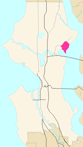
Haller Lake is a small lake and neighborhood in north central Seattle, Washington, named for Theodore N. Haller, who platted the neighborhood in 1905. His father, Granville O. Haller, was one of Seattle's early settlers, an army officer who amassed a large estate in the region.
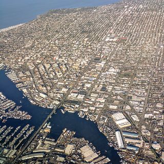
Ballard is a neighborhood in northwestern Seattle, Washington, United States. Formerly an independent city, the City of Seattle's official boundaries define it as bounded to the north by Crown Hill, to the east by Greenwood, Phinney Ridge and Fremont, to the south by the Lake Washington Ship Canal, and to the west by Puget Sound's Shilshole Bay. Other neighborhood or district boundaries existed in the past; these are recognized by various Seattle City Departments, commercial or social organizations, and other Federal, State, and local government agencies.

Shilshole Bay is the part of Puget Sound east of a line drawn northeasterly from Seattle's West Point in the southwest to its Golden Gardens Park in the northeast. On its shores lie Discovery Park, the Lawton Wood section of the Magnolia neighborhood, the neighborhood of Ballard, and Golden Gardens Park. It is home to the Shilshole Bay Marina on Ballard's Seaview Avenue N.W. and communicates with the Lake Washington Ship Canal via the Ballard Locks.

Green Lake is a neighborhood in north central Seattle, Washington. Its centerpiece is the lake and park after which it is named.

West Seattle is a conglomeration of neighborhoods in Seattle, Washington, United States. It comprises two of the thirteen districts, Delridge and Southwest, and encompasses all of Seattle west of the Duwamish River. It was incorporated as an independent town in 1902 before being annexed by Seattle five years later. Among the area's attractions are its saltwater beach parks along Elliott Bay and Puget Sound, including Alki Beach Park and Lincoln Park. The area is also known for its views of the Olympic Mountains to the west and the Cascade Range to the east. One-third of Seattle's green space and urban forest is located in West Seattle, much of it in the West Duwamish Greenbelt.
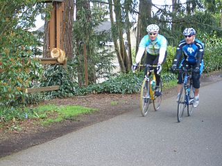
The Burke–Gilman Trail is a rail trail in King County, Washington. The 20-mile (32 km) multi-use recreational trail is part of the King County Regional Trail System and occupies an abandoned Seattle, Lake Shore and Eastern Railway (SLS&E) corridor.

Phinney Ridge is a neighborhood in north central Seattle, Washington, United States. It is named after the ridge which runs north and south, separating Ballard from Green Lake, from approximately N. 45th to N. 80th Street. The ridge, in turn, is named after Guy C. Phinney, lumber mill owner and real estate developer, whose estate was bought by the city and turned into Woodland Park in 1899. Phinney's estate had included a private menagerie, and the western half of the park became what is now the Woodland Park Zoo.

Meridian or Tangletown is the part of Seattle's Wallingford neighborhood that lies north of N 50th Street, near Green Lake. Of note are its "K streets": Kensington, Kenwood, Keystone, and Kirkwood Places N.

Greenwood is a neighborhood in north central Seattle, Washington, United States. The intersection of Greenwood Avenue North and North 85th Street is the commercial center. Greenwood is known for its numerous bars, restaurants, coffee houses, theatres and specialty stores. Greenwood's main thoroughfares are Greenwood Avenue North and N. 85th streets.

The Ballard Terminal Railroad Company LLC operates two Class III short line terminal railroads in western Washington, United States. Founded in 1997 to operate a three-mile spur through Seattle's Ballard neighborhood, the Ballard Terminal Railroad has expanded to operate two additional lines in the Puget Sound area, including Eastside Freight Railroad from Snohomish to Woodinville, Washington, and Meeker Southern Railroad, a 5 mi (8.0 km) segment from East Puyallup ("Meeker") to McMillin, Washington. Eastside Freight Railroad has ceased operation as of mid 2020.

Broadmoor is an 85 acre gated residential community with a 115 acre golf course in Seattle, Washington, United States. It is bounded on the west by the Washington Park Arboretum; on the south by East Madison Street, beyond which is the Washington Park neighborhood; on the east by 37th Avenue East, beyond which is the Madison Park neighborhood; and on the north by Union Bay marshland. It was founded on September 10, 1924.
Laurelhurst is a residential neighborhood in northeastern Seattle, Washington, US. It is bounded on the northeast by Ivanhoe Place N.E., beyond which is Windermere; on the northwest by Sand Point Way N.E. and N.E. 45th Street, beyond which are Hawthorne Hills, Ravenna, and University Village; on the west by Mary Gates Memorial Drive N.E., beyond which is the East Campus of the University of Washington; on the southwest by Union Bay; and on the east by Lake Washington. Seattle Children's Hospital is located in its northwest corner. Once a seasonal campground of the Duwamish people, the neighborhood has been a part of Seattle since its annexation in 1910.

Sand Point is a neighborhood in Seattle, Washington, United States, named after and consisting mostly of the Sand Point peninsula that juts into Lake Washington, which is itself largely given over to Magnuson Park. Its southern boundary can be said to be N.E. 65th Street, beyond which are Windermere and Hawthorne Hills; its northern boundary, N.E. 95th Street, beyond which is Lake City. The western limit of the neighborhood, beyond which are View Ridge and Wedgwood, is not fixed and can be said to be anywhere up the hill that extends west from Sand Point Way N.E. as far as 35th Avenue N.E. It is also the former home of Seattle Naval Air Station.

Crown Hill is a neighborhood in the city of Seattle, in the U.S. state of Washington.

Atlantic is a neighborhood in the Central District of Seattle, Washington, United States. It is the northernmost neighborhood in the Rainier Valley area, located between Mount Baker Ridge and Beacon Hill, and may also be considered part of South Seattle. It is home to the Judkins Park neighborhood.
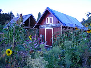
A P-Patch is a parcel of property used for gardening; the term is specific to Seattle, Washington. The "P" originally stood for "Picardo", after the family who owned Picardo Farm in Seattle's Wedgwood neighborhood, part of which became the original P-Patch.
North Beach / Blue Ridge is a neighborhood in the city of Seattle, in the U.S. state of Washington.

Westlake is a neighborhood in Seattle, Washington. It was named after its location on the western shore of Lake Union. It is a relatively narrow neighborhood, there being only a few blocks between the shoreline and its western limit at Aurora Avenue N., beyond which is Queen Anne. To the south beyond Aloha Street is South Lake Union, and to the north across the Fremont Cut is Fremont. Its main thoroughfares are Dexter and Westlake Avenues N..

The Ballard Avenue Historic District is a section of downtown Ballard in Seattle, Washington, that was listed on the National Register of Historic Places in 1976. The district consists of Ballard Avenue N.W. between N.W. Market Street and N.W. Dock Place, and is located near to and along Salmon Bay. After initial work by the Ballard Avenue Association and the city of Seattle's Urban Conservation Division, Seattle mayor Wes Uhlman signed the ordinances that led to the national recognition of the area. The neighborhood of Ballard is known for a large historic population and presence of immigrants from Sweden, and King Gustaf of Sweden read the proclamation inducting the district to the historical registry in 1976, and at the same time dedicated the new bell tower at Ballard's Marvin's Garden Park, which housed the original bell from Ballard's old city hall. The historic markers that can be seen on 26 of the buildings were created and erected by the Ballard Historical Society.

Loyal Heights is a neighborhood in Seattle, Washington. It is considered part of greater Ballard.
