
Delaware is a state in the Mid-Atlantic region of the United States, bordering Maryland to its south and west; Pennsylvania to its north; and New Jersey and the Atlantic Ocean to its east. The state takes its name from the nearby Delaware River named after Thomas West, 3rd Baron De La Warr, an English nobleman and Virginia's first colonial governor.

Chester County, colloquially known as Chesco, is a county in the southeastern part of the U.S. state of Pennsylvania. As of the 2020 census, the population was 534,413, increasing by 7.1% from 498,886 in 2010. The county seat and most populated municipality is West Chester. Chester County was one of the three original Pennsylvania counties created by William Penn in 1682. It was named for Chester, England.

View Park−Windsor Hills is an unincorporated community in Los Angeles County, California.

Newark is a city in New Castle County, Delaware, United States. It is located 12 miles (19 km) west-southwest of Wilmington. According to the 2010 Census, the population of the city is 31,454. Newark is home to the University of Delaware.
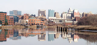
Wilmington is the largest and most populous city in the U.S. state of Delaware. The city was built on the site of Fort Christina, the first Swedish settlement in North America. It lies at the confluence of the Christina River and Brandywine River, near where the Christina flows into the Delaware River. It is the county seat of New Castle County and one of the major cities in the Delaware Valley metropolitan area. Wilmington was named by Proprietor Thomas Penn after his friend Spencer Compton, Earl of Wilmington, who was prime minister during the reign of George II of Great Britain.

The Delaware Valley is the valley through which the Delaware River flows. By extension, this toponym is commonly used to refer to Greater Philadelphia or the Philadelphia metropolitan area. The Delaware Valley is coterminous with a metropolitan statistical area (MSA) and broader combined statistical area (CSA), and is composed of counties located in Southeastern Pennsylvania, South Jersey, Delaware, and the Eastern Shore of Maryland. As of the 2010 Census, the MSA has a population of over 6 million, while the CSA has a population of over 7.1 million.
U.S. Route 13 is a north–south U.S. highway established in 1926 that runs for 517 miles (832 km) from Interstate 95 (I-95) just north of Fayetteville, North Carolina to US 1 in the northeastern suburbs of Philadelphia, Pennsylvania, in Morrisville. In all, it traverses five states in the Atlantic coastal plain region. It follows the Atlantic coast more closely than does the main north–south U.S. highway of the region, US 1. Its routing is largely rural, the notable exceptions being the Hampton Roads area in Virginia and the northern end of the highway in Delaware and Pennsylvania. It is also notable for being the main thoroughfare for the Delmarva peninsula and carrying the Chesapeake Bay Bridge–Tunnel to it in Virginia.
The United New Jersey Railroad and Canal Company (UNJ&CC) was a railroad company which began as the important Camden & Amboy Railroad (C&A), whose 1830 lineage began as one of the eight or ten earliest permanent North American railroads, and among the first common carrier transportation companies whose prospectus marketed an enterprise aimed at carrying passengers fast and competing with stagecoaches between New York Harbor and Philadelphia-Trenton. Among the other earliest chartered or incorporated railroads, only the Mohawk and Hudson Railroad and Baltimore and Ohio Railroad were chartered with passenger services in mind. Later, after mergers, the UNJ&CC became a subsidiary part of the Pennsylvania Railroad (PRR) system in New Jersey by the later merger and acquisition of several predecessor companies in 1872; these purchases also included the PRR's main line to New York City. Prior to 1872, its main lines were the Camden and Amboy Rail Road and Transportation Company, the first railroad in New Jersey and one of the first railroads in the United States.

Bridgeville is a hamlet southeast of Monticello, New York located in the southern Catskill Mountains in the Town of Thompson, County of Sullivan, and State of New York, United States. Bridgeville is located on the Neversink River on New York State Route 17, at an elevation of 1,081 feet (329 m). It has hilly terrain.

The Millstone River is a 38.6-mile-long (62.1 km) tributary of the Raritan River in central New Jersey in the United States.

George Strausser Messersmith was a United States ambassador to Austria, Cuba, Mexico, and Argentina. Messersmith also served as head of the US Consulate in Germany from 1930 to 1934, during the rise of the Nazi Party.

Moodna Creek is a small tributary of the Hudson River that drains eastern Orange County, New York. At 15.5 miles (25 km) in length from its source at the confluence of Cromline Creek and Otter Kill west of Washingtonville, it is the longest stream located entirely within the county.
Windsor Hills Historic District is a national historic district in Baltimore, Maryland, United States. It is a cohesive residential suburb defined by rolling topography, winding, picturesque streets, stone garden walls, walks and private alley ways, early-20th century garden apartments, duplexes, and freestanding residences. Structures are predominantly of frame construction with locally quarried stone foundations. Windsor Hills developed over a period from about 1895 through 1929. The dominant styles include Shingle cottages, Dutch Colonial Revival houses, Foursquares, and Craftsman Bungalows.

Phillips Hill is an unincorporated community in Sussex County, Delaware, United States. Phillips Hill is located on Delaware Route 24 and Delaware Route 30, southwest of Millsboro.
Pennyhill is an unincorporated community in New Castle County, Delaware, United States. Pennyhill is located north of U.S. Route 13 Business and west of Delaware Route 3 northeast of Wilmington. Delaware State Police Troop 1 is located in Pennyhill.
Wrangle Hill is an unincorporated community in New Castle County, Delaware, United States. Wrangle Hill is located at the intersection of U.S. Route 13, Delaware Route 7, and Delaware Route 72 west of Delaware City. The community was named after a feud between two early families.
Gravel Hill is an unincorporated community in Sussex County, Delaware, United States. Gravel Hill is located at the intersection of U.S. Route 9/Delaware Route 404 and Delaware Route 30 east of Georgetown.

Port Mercer is an unincorporated community located where the municipal boundaries of Lawrence Township, Princeton and West Windsor Township intersect in Mercer County, New Jersey, United States. It is the location of the historic Port Mercer Canal House along the Delaware and Raritan Canal.


