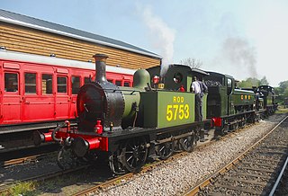
The Kent and East Sussex Railway (K&ESR) refers to both a historical private railway company in Kent and East Sussex in England, as well as a heritage railway currently running on part of the route of the historical company.

Headcorn railway station is on the South Eastern Main Line in England, serving the village of Headcorn, Kent. It is 45 miles 20 chains (72.8 km) down the line from London Charing Cross. The station and all trains that serve the station are operated by Southeastern.

Robertsbridge railway station is on the Hastings line in the south of England and serves the village of Robertsbridge, East Sussex. It is 49 miles 47 chains (79.8 km) down the line from London Charing Cross. The station and all trains serving it are operated by Southeastern.

Christ's Hospital railway station is near Horsham in West Sussex, England. It is 40 miles 7 chains (64.5 km) down the line from London Bridge via Redhill. It was opened in 1902 by the London, Brighton and South Coast Railway and was intended primarily to serve Christ's Hospital, a large independent school which had moved to the area in that year. It now also serves the rural area to the west of Horsham.
Granborough Road railway station was a station serving the village of Granborough, to the north of Quainton in Buckinghamshire, England.
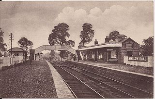
Winslow Road railway station served the village of East Claydon near Winslow to the north of Quainton in Buckinghamshire, England. It was the second station to serve the town after Winslow on the Varsity Line.

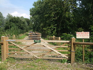
The Rother Valley Railway (RVR) is a heritage railway project based at Robertsbridge in East Sussex, England. It takes its name from the original name for what later became the Kent and East Sussex Railway, running from Robertsbridge through to Headcorn in Kent, via Tenterden. The project is to replace the ‘missing link’ between Robertsbridge, a station on the Tonbridge to Hastings mainline, and Bodiam on the Kent and East Sussex Railway, a heritage railway which operates from Bodiam to Tenterden. A charity, supported by a society of volunteers, is attempting to re-establish the railway link. The RVR began by reinstating the first few hundred yards of line eastwards from Robertsbridge, and also a short stretch westwards from Bodiam. In 2010, the latter section was further extended to reach Junction Road. In summer 2011 work began at Robertsbridge to extend further eastwards to Northbridge Street, which entailed the rebuilding of five bridges. By June 2012, this further extension was also completed. In September 2013, a Gala weekend at Robertsbridge marked the progress to date and the start of the next phase - the re-instatement of the section between Northbridge Street and Junction Road, for which statutory permissions are being sought. While the RVR does not yet feature regular passenger trains, the base at Robertsbridge houses a small shop and visitor centre open to the public each Sunday, utilising a building formerly used as the London terminus of the Orient Express. There is also a small collection of historic railway vehicles in various stages of preservation.

Rolvenden railway station is a heritage railway station on the Kent and East Sussex Railway in Tenterden, Kent, in the United Kingdom.

The Hawkhurst branch line was a short railway line in Kent that connected Hawkhurst, Cranbrook, Goudhurst and Horsmonden with the town of Paddock Wood and the South Eastern and Medway Valley lines, a distance of 11 miles 24 chains.

Tenterden Town railway station is a heritage railway station on the Kent and East Sussex Railway in Tenterden, Kent, England.

The High Weald Landscape Trail (HWLT) is a 145-kilometre (90 mi) route in England between Horsham, West Sussex and Rye, East Sussex, designed to pass through the main landscape types of the High Weald Area of Outstanding Natural Beauty (AONB). It does not follow the highest ground, and the eastern section is only a few feet above sea level. It keeps to the northern edge of the High Weald except in the west where it runs close to the southern edge for a short distance.
Junction Road Halt, also known as Junction Road , was a halt station on the Kent and East Sussex Railway. It was located on the eastern side of the level crossing across the B2244 Junction Road near the hamlet of Udiam in East Sussex, England. Closed for passengers in 1954 and freight in 1961 with the line, The line through Junction Road Halt may yet be revived as the Rother Valley Railway, a preservation society, is proposing to reopen the line from Robertsbridge to Bodiam.

Salehurst Halt was a halt station on the Kent and East Sussex Railway which served the village of Salehurst in East Sussex, England. The station was reached by a footpath leading south from the village church in Salehurst. Closed in 1954, Salehurst Halt may yet see trains again as the Rother Valley Railway, a preservation society, is proposing to reopen the line from Robertsbridge to Bodiam, including the line through the halt.
Dixter Halt was a short-lived halt station on the Kent and East Sussex Railway on an unmade road leading to Great Dixter house near Northiam in East Sussex. Opened in May 1981 it was used for occasional special services to and from Bodiam until the line from Northiam was finally reopened for regular passenger services to Bodiam in 2000.

Tenterden St. Michael's was a railway station on the Kent and East Sussex Railway which served the Tenterden suburb of St Michaels in Kent, England. The station was situated on the southern side of a level crossing to the south of St. Michael's tunnel, one of the line's main civil engineering features. Closed in 1954, nothing remains of St. Michael's today: a footpath and cycleway runs through the site.

Northiam railway station is on the Kent and East Sussex Railway. It is located to the west of the level crossing on the A28 road linking the Kentish village of Newenden and the East Sussex village of Northiam. Having served the area for over sixty years, the station closed with the line in 1961, but was later reopened in 1990 by the Kent and East Sussex Railway heritage organisation.
The Cranbrook and Tenterden Light Railway was a railway line which was to have linked the Hawkhurst Branch Line with the Rother Valley Railway in Kent. Although it received authorisation for its construction, only a short section of it was ever built. This section is open today as part of the Kent and East Sussex Railway.

Cheltenham Spa Malvern Road railway station was a station in the town of Cheltenham.

Turvey was a railway station on the Bedford to Northampton Line which served the village of Turvey from 1872 to 1962.
Headcorn Junction railway station was the Kent and East Sussex Railway's northern terminus. It was adjacent to the South Eastern and Chatham Railway's Headcorn station. It opened in 1905 and closed in 1954.

