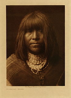
The Yavapai are a Native American people of central and western Arizona.

Yavapai County is near the center of the U.S. state of Arizona. As of the 2010 census, its population was 211,073. The county seat is Prescott.

Camp Verde is a town in Yavapai County, Arizona, United States. As of the 2010 census, the population of the town is 10,873.

Clarkdale is a town in Yavapai County, Arizona, United States. The Verde River flows through the town as does Bitter Creek, an intermittent tributary of the river. According to the 2010 census, the population of the town was 4,097.

Cornville is a census-designated place (CDP) in Yavapai County, Arizona, United States. The population as of the 2010 United States Census was 3,280, down from 3,335 at the 2000 census. The Cornville CDP includes the communities of Cornville and Page Springs.

Montezuma Castle National Monument protects a set of well-preserved dwellings located in Camp Verde, Arizona which were built and used by the Sinagua people, a pre-Columbian culture closely related to the Hohokam and other indigenous peoples of the southwestern United States, between approximately 1100 and 1425 AD. The main structure comprises five stories and twenty rooms, and was built over the course of three centuries.

Native Americans have inhabited what is now Arizona for thousands of years. It remains a state with one of the largest percentages of Native Americans in the United States, and has the second largest total Native American population of any state. In addition, the majority of the Navajo Nation, the largest Native American reservation in the US, and the entire Tohono O'odham Nation, the second largest, are located in Arizona. Over a quarter of the area of the state is reservation land.

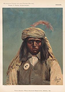
The Western Apache live primarily in east central Arizona, in the United States. Most live within reservations. The Fort Apache Indian Reservation, San Carlos Apache Indian Reservation, Yavapai-Apache Nation, Tonto Apache, and the Fort McDowell Yavapai Nation are home to the majority of Western Apache and are the bases of their federally recognized tribes. In addition, there are numerous bands. The Western Apache bands call themselves Ndee (Indé) ; because of dialectical differences the Pinaleño/Pinal and Arivaipa/Aravaipa bands of the San Carlos Apache pronounce the word Innee or Nnēē:.

The Sierra Estrella is a mountain range located southwest of Phoenix, Arizona. Much of the range falls within the Gila River Indian Reservation, but 14,400 acres (5,800 ha) of BLM land is protected as the Sierra Estrella Wilderness.

The Yavapai-Prescott Indian Tribe, formerly known as the Yavapai-Prescott Tribe of the Yavapai Reservation, a federally recognized tribe of Yavapai people. Fewer than 200 people are enrolled in the tribe.
The Tonto Apache is one of the groups of Western Apache people. The term is also used for their dialect, one of the three dialects of the Western Apache language. The Chiricahua living to the south called them Ben-et-dine or binii?e'dine'. The neighboring Western Apache ethnonym for them was Koun'nde, from which the Spanish derived their use of Tonto for the group. The kindred but enemy Navajo to the north called both the Tonto Apache and their allies, the Yavapai, Dilzhʼíʼ dinéʼiʼ - “People with high-pitched voices”).
The Hualapai is a federally recognized Indian tribe in Arizona with over 2300 enrolled members. Approximately 1353 enrolled members reside on the Hualapai Indian reservation, which spans over three counties in Northern Arizona.

The San Carlos Apache Indian Reservation, in southeastern Arizona, United States, was established in 1872 as a reservation for the Chiricahua Apache tribe as well as surrounding Yavapai and Apache bands forcibly removed from their original homelands under a strategy devised by General Crook of using an Apache to catch an Apache. Also known as "Hell's Forty Acres" under United States occupation because of deplorable health and environmental conditions, today's San Carlos Apaches successfully operate a Chamber of Commerce, the Apache Gold Casino, a Language Preservation program, a Culture Center, and a Tribal College.

Fort McDowell is an unincorporated community in Maricopa County, Arizona, United States. Fort McDowell is 23 miles northeast of Phoenix, Arizona. Fort McDowell has a post office with ZIP code 85264.

Tuzigoot National Monument preserves a 2- to 3-story pueblo ruin on the summit of a limestone and sandstone ridge just east of Clarkdale, Arizona, 120 feet above the Verde River floodplain. The Tuzigoot Site is an elongated complex of stone masonry rooms that were built along the spine of a natural outcrop in the Verde Valley. The central rooms stand higher than the others and they appear to have served public functions. The pueblo has 110 rooms. The National Park Service currently administers 58 acres, within an authorized boundary of 834 acres.
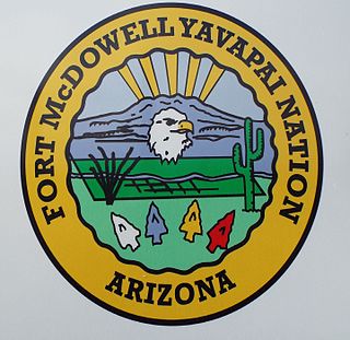
The Fort McDowell Yavapai Nation, formerly the Fort McDowell Mohave-Apache Community of the Fort McDowell Indian Reservation, is a federally recognized tribe and Indian reservation in Maricopa County, Arizona about 23 miles (37 km) northeast of Phoenix.
The Yavapai Wars, or the Tonto Wars, were a series of armed conflicts between the Yavapai and Tonto tribes against the United States in Arizona. The period began no later than 1861, with the arrival of American settlers on Yavapai and Tonto land. At the time, the Yavapai were considered a band of the Western Apache people due to their close relationship with tribes such as the Tonto and Pinal. The wars ended with the Yavapai's and the Tonto's removal from the Camp Verde Reservation to San Carlos on February 27, 1875, now known as Exodus Day.
Vera Brown Starr was the first woman elected as chair of the Yavapai-Apache Nation and served two years in the office, as well as serving over fifteen years on the council. She was one of the delegates to the 1977 National Women's Conference, a major U.S. women's conference held in conjunction with the International Women's Year celebrations of the United Nations. In 2012, her name was inscribed on an arch recognizing women who were Native American leaders at the University of Arizona.