middle:Kejonuma Leisure Land, Furukawa Station
lower:Naruko Dam, Mount Kagoho"},"image_flag":{"wt":"Flag of Osaki, Miyagi.svg"},"flag_alt":{"wt":""},"image_seal":{"wt":"Emblem of Osaki, Miyagi.svg"},"seal_alt":{"wt":""},"image_shield":{"wt":""},"shield_alt":{"wt":""},"image_blank_emblem":{"wt":""},"nickname":{"wt":""},"motto":{"wt":""},"image_map":{"wt":"Osaki in Miyagi Ja.svg"},"map_alt":{"wt":""},"map_caption":{"wt":"Location of Ōsaki in Miyagi Prefecture"},"pushpin_map":{"wt":"Japan"},"pushpin_label_position":{"wt":""},"pushpin_map_alt":{"wt":""},"pushpin_map_caption":{"wt":" "},"coordinates":{"wt":"{{coord|38|34|37.6|N|140|57|20.1|E|region:JP|display=inline,title}}"},"coor_pinpoint":{"wt":""},"coordinates_footnotes":{"wt":"\n"},"subdivision_type":{"wt":"[[List of sovereign states|Country]]"},"subdivision_name":{"wt":"[[Japan]]"},"subdivision_type1":{"wt":"[[List of regions of Japan|Region]]"},"subdivision_name1":{"wt":"[[Tōhoku region|Tōhoku]]"},"subdivision_type2":{"wt":"[[Prefectures of Japan|Prefecture]]"},"subdivision_name2":{"wt":"[[Miyagi Prefecture|Miyagi]]"},"subdivision_type3":{"wt":""},"subdivision_name3":{"wt":""},"established_title":{"wt":"First official recorded"},"established_date":{"wt":"695 AD"},"established_title2":{"wt":"Narugo Town Settled"},"established_date2":{"wt":"April 20, 1921"},"established_title3":{"wt":"Furukawa City Settled"},"established_date3":{"wt":"December 15, 1950"},"established_title4":{"wt":"As current city named"},"established_date4":{"wt":"March 31, 2006"},"founder":{"wt":""},"named_for":{"wt":""},"seat_type":{"wt":""},"seat":{"wt":""},"government_footnotes":{"wt":""},"leader_party":{"wt":""},"leader_title":{"wt":"Mayor"},"leader_name":{"wt":"Yasushi Ito"},"leader_title1":{"wt":""},"leader_name1":{"wt":"\n"},"total_type":{"wt":""},"unit_pref":{"wt":"\n"},"area_magnitude":{"wt":""},"area_footnotes":{"wt":""},"area_total_km2":{"wt":"796.76"},"area_land_km2":{"wt":""},"area_water_km2":{"wt":""},"area_water_percent":{"wt":""},"area_note":{"wt":""},"elevation_footnotes":{"wt":""},"elevation_m":{"wt":""},"population_footnotes":{"wt":""},"population_total":{"wt":"128763"},"population_as_of":{"wt":"May 1, 2020"},"population_density_km2":{"wt":"auto"},"population_est":{"wt":""},"pop_est_as_of":{"wt":""},"population_demonym":{"wt":""},"population_note":{"wt":""},"timezone1":{"wt":"[[Japan Standard Time]]"},"utc_offset1":{"wt":"+9"},"timezone1_DST":{"wt":""},"utc_offset1_DST":{"wt":""},"postal_code_type":{"wt":""},"postal_code":{"wt":""},"area_code_type":{"wt":""},"area_code":{"wt":""},"blank_name_sec1":{"wt":"Phone number"},"blank_info_sec1":{"wt":"0229-23-2111"},"blank1_name_sec1":{"wt":"Address"},"blank1_info_sec1":{"wt":"1-1 Furukawa Nanokamachi, Ōsaki-shi, Miyagi-ken 989-6188\n"},"blank_name_sec2":{"wt":"[[Köppen climate classification|Climate]]"},"blank_info_sec2":{"wt":"[[Humid subtropical climate|Cfa]]\n"},"website":{"wt":"{{Official|1=http://www.city.osaki.miyagi.jp/}}"},"footnotes":{"wt":""},"module":{"wt":"{{Infobox place symbols| embedded=yes\n | tree = [[Rose]]\n | flower = [[Cornus florida|Flowering Dogwood]]\n | bird = \n | flowering_tree = \n | butterfly = \n | fish = \n | other_symbols = \n}}"}},"i":0}}]}" id="mwAg">City in Tōhoku, Japan
Ōsaki 大崎市 | |
---|---|
![]() upper:Furukawa festival, Kashima-dai middle:Kejonuma Leisure Land, Furukawa Station lower:Naruko Dam, Mount Kagoho | |
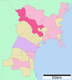
![]() Location of Ōsaki in Miyagi Prefecture | |
Coordinates: 38°34′37.6″N140°57′20.1″E / 38.577111°N 140.955583°E | |
Country | Japan |
Region | Tōhoku |
Prefecture | Miyagi |
First official recorded | 695 AD |
Narugo Town Settled | April 20, 1921 |
Furukawa City Settled | December 15, 1950 |
As current city named | March 31, 2006 |
Government | |
• Mayor | Yasushi Ito |
Area | |
• Total | 796.76 km2 (307.63 sq mi) |
Population (May 1, 2020) | |
• Total | 128,763 |
• Density | 160/km2 (420/sq mi) |
Time zone | UTC+9 (Japan Standard Time) |
Phone number | 0229-23-2111 |
Address | 1-1 Furukawa Nanokamachi, Ōsaki-shi, Miyagi-ken 989-6188 |
Climate | Cfa |
Website | Official website |
Symbols | |
Flower | Flowering Dogwood |
Tree | Rose |
Ōsaki (大崎市, Ōsaki-shi) is a city located in Miyagi Prefecture, Japan. As of 1 May 2020 [update] , the city had an estimated population of 128,763 in 51,567 households, [1] and a population density of 160 persons per km2. The total area of the city is 796.76 square kilometres (307.63 sq mi). Ōsaki is a member of the World Health Organization’s Alliance for Healthy Cities (AFHC). [2]
Ōsaki is in north-central Miyagi Prefecture in the northern Sendai Plain. The Furukawa area in the center of the city is a base for commercial and service industries in the northern portion of Miyagi Prefecture, and the Naruko area in the northwestern of the city is noted for hot spring tourism . The Kashimadai and Matsuyama districts in the southeastern part of the city are within the commuting zone of Sendai.
Ōsaki has a humid subtropical climate (Köppen climate classification Cfa) characterized by hot summers and mild winters. The average annual temperature in Ōsaki is 11.5 °C. The average annual rainfall is 1249 mm with September as the wettest month. The temperatures are highest on average in August, at around 24.4 °C, and lowest in January, at around -0.6 °C. [3]
Climate data for Kashimadai, Ōsaki (1991−2020 normals, extremes 1976−present) | |||||||||||||
---|---|---|---|---|---|---|---|---|---|---|---|---|---|
Month | Jan | Feb | Mar | Apr | May | Jun | Jul | Aug | Sep | Oct | Nov | Dec | Year |
Record high °C (°F) | 15.3 (59.5) | 18.4 (65.1) | 22.7 (72.9) | 29.6 (85.3) | 31.3 (88.3) | 33.2 (91.8) | 35.5 (95.9) | 36.1 (97.0) | 34.2 (93.6) | 29.6 (85.3) | 23.5 (74.3) | 21.1 (70.0) | 36.1 (97.0) |
Mean daily maximum °C (°F) | 4.5 (40.1) | 5.5 (41.9) | 9.3 (48.7) | 15.1 (59.2) | 19.8 (67.6) | 22.9 (73.2) | 26.3 (79.3) | 27.9 (82.2) | 24.8 (76.6) | 19.5 (67.1) | 13.2 (55.8) | 7.2 (45.0) | 16.3 (61.4) |
Daily mean °C (°F) | 0.3 (32.5) | 0.8 (33.4) | 3.9 (39.0) | 9.1 (48.4) | 14.7 (58.5) | 18.7 (65.7) | 22.2 (72.0) | 23.5 (74.3) | 20.0 (68.0) | 14.0 (57.2) | 7.6 (45.7) | 2.5 (36.5) | 11.4 (52.6) |
Mean daily minimum °C (°F) | −4.1 (24.6) | −3.9 (25.0) | −1.7 (28.9) | 3.0 (37.4) | 10.1 (50.2) | 15.2 (59.4) | 19.2 (66.6) | 20.2 (68.4) | 15.8 (60.4) | 8.7 (47.7) | 2.2 (36.0) | −1.9 (28.6) | 6.9 (44.4) |
Record low °C (°F) | −17.3 (0.9) | −17.1 (1.2) | −13.4 (7.9) | −6.2 (20.8) | 0.1 (32.2) | 6.8 (44.2) | 11.2 (52.2) | 10.8 (51.4) | 4.7 (40.5) | −2.1 (28.2) | −6.1 (21.0) | −17.9 (−0.2) | −17.9 (−0.2) |
Average precipitation mm (inches) | 35.1 (1.38) | 29.2 (1.15) | 72.2 (2.84) | 84.7 (3.33) | 95.1 (3.74) | 119.4 (4.70) | 155.4 (6.12) | 129.3 (5.09) | 166.7 (6.56) | 143.7 (5.66) | 62.7 (2.47) | 41.0 (1.61) | 1,134.5 (44.67) |
Average precipitation days (≥ 1.0 mm) | 5.3 | 5.2 | 7.6 | 8.5 | 9.4 | 10.1 | 13.1 | 10.6 | 11.6 | 9.0 | 7.0 | 6.5 | 103.9 |
Mean monthly sunshine hours | 154.7 | 161.2 | 184.1 | 188.8 | 189.2 | 146.8 | 129.2 | 150.6 | 130.3 | 141.5 | 139.1 | 133.2 | 1,848.7 |
Source: Japan Meteorological Agency [4] [5] |
Climate data for Furukawa, Ōsaki (1991−2020 normals, extremes 1976−present) | |||||||||||||
---|---|---|---|---|---|---|---|---|---|---|---|---|---|
Month | Jan | Feb | Mar | Apr | May | Jun | Jul | Aug | Sep | Oct | Nov | Dec | Year |
Record high °C (°F) | 15.3 (59.5) | 17.3 (63.1) | 22.5 (72.5) | 29.9 (85.8) | 33.3 (91.9) | 34.0 (93.2) | 35.6 (96.1) | 36.5 (97.7) | 35.0 (95.0) | 30.1 (86.2) | 23.5 (74.3) | 20.5 (68.9) | 36.5 (97.7) |
Mean daily maximum °C (°F) | 3.7 (38.7) | 4.9 (40.8) | 8.9 (48.0) | 15.4 (59.7) | 20.5 (68.9) | 23.7 (74.7) | 26.9 (80.4) | 28.4 (83.1) | 24.8 (76.6) | 19.3 (66.7) | 12.9 (55.2) | 6.5 (43.7) | 16.3 (61.4) |
Daily mean °C (°F) | 0.0 (32.0) | 0.6 (33.1) | 3.8 (38.8) | 9.4 (48.9) | 15.1 (59.2) | 19.0 (66.2) | 22.5 (72.5) | 23.7 (74.7) | 20.0 (68.0) | 13.9 (57.0) | 7.6 (45.7) | 2.4 (36.3) | 11.5 (52.7) |
Mean daily minimum °C (°F) | −3.8 (25.2) | −3.5 (25.7) | −0.9 (30.4) | 3.6 (38.5) | 10.3 (50.5) | 15.3 (59.5) | 19.2 (66.6) | 20.3 (68.5) | 16.0 (60.8) | 9.0 (48.2) | 2.7 (36.9) | −1.5 (29.3) | 7.2 (45.0) |
Record low °C (°F) | −17.6 (0.3) | −15.9 (3.4) | −12.1 (10.2) | −4.7 (23.5) | 1.4 (34.5) | 7.0 (44.6) | 11.5 (52.7) | 12.0 (53.6) | 3.7 (38.7) | −1.4 (29.5) | −5.6 (21.9) | −15.9 (3.4) | −17.6 (0.3) |
Average precipitation mm (inches) | 44.9 (1.77) | 35.0 (1.38) | 70.4 (2.77) | 82.7 (3.26) | 102.8 (4.05) | 123.3 (4.85) | 169.9 (6.69) | 139.1 (5.48) | 160.4 (6.31) | 129.2 (5.09) | 62.8 (2.47) | 53.1 (2.09) | 1,173.5 (46.20) |
Average snowfall cm (inches) | 80 (31) | 55 (22) | 24 (9.4) | 1 (0.4) | 0 (0) | 0 (0) | 0 (0) | 0 (0) | 0 (0) | 0 (0) | 1 (0.4) | 42 (17) | 200 (79) |
Average precipitation days (≥ 1.0 mm) | 8.9 | 7.6 | 9.1 | 9.1 | 9.5 | 10.6 | 13.5 | 11.5 | 11.6 | 9.9 | 9.0 | 9.5 | 119.8 |
Average snowy days (≥ 3 cm) | 10.0 | 7.0 | 3.0 | 0.1 | 0 | 0 | 0 | 0 | 0 | 0 | 0.1 | 4.5 | 24.7 |
Mean monthly sunshine hours | 130.8 | 148.7 | 176.3 | 190.7 | 192.3 | 147.8 | 124.8 | 141.3 | 125.1 | 137.2 | 131.7 | 115.4 | 1,762 |
Source: Japan Meteorological Agency [6] [7] |
Climate data for Kawatabi, Ōsaki (1991−2020 normals, extremes 1976−present) | |||||||||||||
---|---|---|---|---|---|---|---|---|---|---|---|---|---|
Month | Jan | Feb | Mar | Apr | May | Jun | Jul | Aug | Sep | Oct | Nov | Dec | Year |
Record high °C (°F) | 14.5 (58.1) | 15.7 (60.3) | 21.3 (70.3) | 28.2 (82.8) | 33.4 (92.1) | 34.2 (93.6) | 35.8 (96.4) | 36.5 (97.7) | 35.5 (95.9) | 29.4 (84.9) | 22.8 (73.0) | 18.8 (65.8) | 36.5 (97.7) |
Mean daily maximum °C (°F) | 2.7 (36.9) | 3.7 (38.7) | 7.7 (45.9) | 14.5 (58.1) | 19.9 (67.8) | 23.0 (73.4) | 26.2 (79.2) | 27.5 (81.5) | 23.8 (74.8) | 18.3 (64.9) | 12.0 (53.6) | 5.5 (41.9) | 15.4 (59.7) |
Daily mean °C (°F) | −0.9 (30.4) | −0.4 (31.3) | 2.7 (36.9) | 8.5 (47.3) | 14.0 (57.2) | 18.0 (64.4) | 21.6 (70.9) | 22.7 (72.9) | 18.9 (66.0) | 12.8 (55.0) | 6.7 (44.1) | 1.5 (34.7) | 10.5 (50.9) |
Mean daily minimum °C (°F) | −4.4 (24.1) | −4.3 (24.3) | −1.8 (28.8) | 2.7 (36.9) | 8.6 (47.5) | 13.6 (56.5) | 18.1 (64.6) | 19.1 (66.4) | 14.9 (58.8) | 8.0 (46.4) | 2.1 (35.8) | −2.1 (28.2) | 6.2 (43.2) |
Record low °C (°F) | −14.3 (6.3) | −13.9 (7.0) | −10.9 (12.4) | −5.7 (21.7) | 0.0 (32.0) | 4.2 (39.6) | 7.9 (46.2) | 10.6 (51.1) | 2.8 (37.0) | −1.4 (29.5) | −5.7 (21.7) | −13.3 (8.1) | −14.3 (6.3) |
Average precipitation mm (inches) | 113.4 (4.46) | 82.8 (3.26) | 105.1 (4.14) | 110.2 (4.34) | 132.1 (5.20) | 161.5 (6.36) | 216.6 (8.53) | 205.9 (8.11) | 183.1 (7.21) | 143.6 (5.65) | 105.8 (4.17) | 128.6 (5.06) | 1,697 (66.81) |
Average snowfall cm (inches) | 144 (57) | 115 (45) | 61 (24) | 4 (1.6) | 0 (0) | 0 (0) | 0 (0) | 0 (0) | 0 (0) | 0 (0) | 7 (2.8) | 85 (33) | 407 (160) |
Average precipitation days (≥ 1.0 mm) | 17.3 | 14.6 | 13.8 | 11.9 | 11.1 | 11.7 | 15.2 | 14.3 | 13.6 | 12.1 | 13.6 | 17.8 | 167 |
Average snowy days (≥ 3 cm) | 14.3 | 12.6 | 6.4 | 0.6 | 0 | 0 | 0 | 0 | 0 | 0 | 0.8 | 8.6 | 43.3 |
Mean monthly sunshine hours | 98.7 | 114.8 | 154.5 | 186.9 | 190.4 | 148.2 | 120.8 | 131.2 | 119.8 | 138.3 | 126.9 | 91.2 | 1,621.7 |
Source: Japan Meteorological Agency [8] [9] |
Akita Prefecture
Miyagi Prefecture
Yamagata Prefecture
Per Japanese census data, [10] the population of Ōsaki has remained relatively steady over the past 60 years.
Year | Pop. | ±% |
---|---|---|
1960 | 138,978 | — |
1970 | 126,057 | −9.3% |
1980 | 130,266 | +3.3% |
1990 | 135,208 | +3.8% |
2000 | 139,313 | +3.0% |
2010 | 135,147 | −3.0% |
2020 | 127,330 | −5.8% |
The area of present-day Ōsaki was part of ancient Mutsu Province, and has been settled since at least the Jōmon period by the Emishi people. During the Nara period, gold was discovered in the area. During later portion of the Heian period, the area was ruled by the Northern Fujiwara. During the Sengoku period, the area was contested by various samurai clans before the area came under the control of the Date clan of Sendai Domain during the Edo period, under the Tokugawa shogunate.
The town of Furukawa was established with the creation of the modern municipalities system on April 1, 1889. It was raised to city status on December 15, 1950.
The city of Ōsaki was established on March 31, 2006, from the merger of the city of Furukawa with the towns of Iwadeyama and Naruko (both from Tamatsukuri District), the towns of Kashimadai, Matsuyama and Sanbongi (all from Shida District), and the town of Tajiri (from Tōda District).
Ōsaki has a mayor-council form of government with a directly elected mayor and a unicameral city legislature of 30 members. Ōsaki contributes four seats to the Miyagi Prefectural legislature. In terms of national politics, the city is part of Miyagi 6th district of the lower house of the Diet of Japan.
The economy of Ōsaki is largely based on agriculture, primarily the cultivation of rice and soybeans. Industry includes electronics, precision machining and construction materials.
East Japan Railway Company (JR East) - Tōhoku Shinkansen
East Japan Railway Company (JR East) - Tōhoku Main Line
East Japan Railway Company (JR East) - Rikuu East Line
Date is a city in Iburi Subprefecture, Hokkaido, Japan. Date was established around 1869, and became a city on April 1, 1972.
Yuzawa is a city located in Akita Prefecture, Japan. As of 31 January 2023, the city had an estimated population of 41,404 in 17551 households and a population density of 52 persons per km2. The total area of the city is 790.91 km2 (305.37 sq mi). Yuzawa claims to be the birthplace of the famous Heian period poet Ono no Komachi.
Kazuno is a city located in Akita Prefecture, Japan. As of 28 March 2023, the city had an estimated population of 28,329 in 12,570 households, and a population density of 40 persons per km2. The total area of the city is 707.52 square kilometres.
Obanazawa is a city located in Yamagata Prefecture, Japan. As of 1 February 2020, the city had an estimated population of 15,237, and a population density of 40.9 persons per km2. The total area of the city is 372.32 square kilometres (144 sq mi).
Takayama is a city located in Gifu Prefecture, Japan. As of 1 January 2019, the city had an estimated population of 88,473 in 35,644 households, and a population density of 41 persons per km2. The total area of the city was 2,177.61 square kilometers (840.78 sq mi) making it the largest city by area in Japan. The high altitude and separation from other areas of Japan kept the area fairly isolated, allowing Takayama to develop its own culture over about a 300-year period.
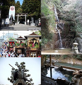
Tanabe is a city located in Wakayama Prefecture, Japan. As of 1 November 2021, the city had an estimated population of 70,972 in 35,076 households and a population density of 69 persons per km2. The total area of the city is 1,026.91 square kilometres (396.49 sq mi). Tanabe is the second most populous city in Wakayama, and the largest in the Kansai region of Japan in terms of area.
Masuda is a city located in Shimane Prefecture, Japan. As of 31 July 2023, the city had an estimated population of 43,885 in 21249 households and a population density of 60 persons per km2. The total area of the city is 733.19 square kilometres (283.09 sq mi).
Saiki is a city located in Ōita Prefecture, Japan. As of 31 October 2023, the city had an estimated population of 65,870 in 32921 households, and a population density of 73 persons per km2. The total area of the city is 903.11 km2 (348.69 sq mi), making it the largest city by area in Kyushu.
Tsushima is an island city grouped in Nagasaki Prefecture, Japan. It is the only city of Tsushima Subprefecture and it encompasses all of Tsushima Island, which lies in the Tsushima Strait north of Nagasaki on the western side of Kyushu, the southernmost mainland island of Japan. As of March 2017, the city has an estimated population of 31,550 and a population density of 45 persons per km2. Its total area is 708.61 km2, 17.3% of the area of Nagasaki Prefecture.
Gero is a city located in Japan's Gifu Prefecture. As of 31 October 2017, the city had an estimated population of 33,283, and a population density of 39 persons per km2, in 12,253 households. The total area of the city was 851.21 square kilometres (328.65 sq mi). The city is famous for its hot springs.
Sakai is a city located in Fukui Prefecture, Japan. As of 10 May 2018, the city had an estimated population of 92,210 in 31,509 households and a population density of 550 persons per km2. The total area of the city was 209.67 square kilometres (80.95 sq mi).
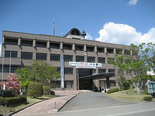
Marumori is a town located in Miyagi Prefecture, Japan. As of 1 June 2020, the town had an estimated population of 13,092, and a population density of 48 persons per km2 in 5,050 households. The total area of the town is 273.30 square kilometres (105.52 sq mi).
Watari is a town located in Miyagi Prefecture, Japan. As of 31 March 2020, the town had an estimated population of 33,459, and a population density of 450 persons per km2 in 12,643 households. The total area of the town is 73.60 square kilometres (28.42 sq mi).
Ōhira is a village located in Miyagi Prefecture, Japan. As of 31 May 2020, the village had an estimated population of 5,918, and a population density of 98 persons per km2 in 2108 households. The total area of the village is 60.32 square kilometres (23.29 sq mi).
Kurihara is a city located in Miyagi Prefecture, Japan. As of 30 April 2020, the city had an estimated population of 66,565, and a population density of 83 persons per km2 in 24,994 households. The total area of the city is 804.97 square kilometres (310.80 sq mi). Parts of the city are within the borders of the Kurikoma Quasi-National Park.
Kitaakita is a city located in Akita Prefecture, Japan. As of 28 February 2023, the city had an estimated population of 29,201, and a population density of 120 persons per km2. and a population density of 25 persons per km2. The total area of the city is 1,152.76 square kilometres (445.08 sq mi).
Minamiaizu is a town located in Fukushima Prefecture, Japan. As of 1 April 2020, the town had an estimated population of 15,158 in 6,575 households, and a population density of 17 persons per km2. The total area of the town was 886.52 square kilometres (342.29 sq mi).
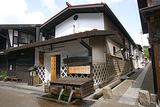
Kiso is a town located in Nagano Prefecture, Japan. As of 5 April 2019, the town had an estimated population of 11,045 in 4892 households, and a population density of 23 persons per km2. The total area of the town is 476.03 square kilometres (183.80 sq mi). Kiso Town is listed as one of The Most Beautiful Villages in Japan.
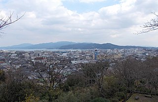
Amakusa is a city located in Kumamoto Prefecture, Japan. As of 31 August 2024, the city had an estimated population of 72,243 in 36029 households, and a population density of 110 persons per km2. The total area of the city is 683.82 km2 (264.02 sq mi).
Shibushi is a city located in Kagoshima Prefecture, Japan. As of 30 April 2024, the city had an estimated population of 28,889 in 15135 households, and a population density of 100 persons per km². The total area of the city is 290.21 km2 (112.05 sq mi).