
Richland County is located in the U.S. state of South Carolina. As of the 2010 census, the population was 384,504, making it the second-most populous county in South Carolina, behind only Greenville County. The 2019 estimated population was 415,759. The county seat and largest city is Columbia, the state capital. The county was founded in 1785. Richland County is part of the Columbia, SC Metropolitan Statistical Area. In 2010, the center of population of South Carolina was located in Richland County, in the city of Columbia.
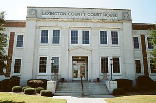
Lexington County is a county located in the U.S. state of South Carolina. As of the 2010 census, the population was 262,391, and the 2019 population estimate was 298,750. Its county seat and largest town is Lexington. The county was chartered in 1785 and was named in commemoration of Lexington, Massachusetts, the site of the Battle of Lexington in the American Revolutionary War. Lexington County is the sixth-largest county in South Carolina and is part of the Columbia, SC Metropolitan Statistical Area.

Cayce is a city in the U.S. state of South Carolina, along the Congaree River. The population was 12,528 at the 2010 census. The estimated population was 14,009 in 2019, and is the third-most populated municipality in Lexington County. The city limits divided between Lexington and Richland Counties, though most of the city's residents live in Lexington County. Most of the city's land in Richland County is predominately rural. Cayce lies along the banks of the Congaree River, which divides the city from the state capital, Columbia, South Carolina. Cayce is also boarded by the city of West Columbia to the north and the town of Springdale to the northwest. Cayce is also part of the Columbia, South Carolina, Metropolitan Statistical Area and the South Carolina Midlands of South Carolina.

Chapin, popularly known as the capital of Lake Murray, is a small lake-town located at the northern tip of Lexington County, South Carolina, United States. Lake Murray separates Chapin from the rest of Lexington County. The population of Chapin was 1,445 according to the 2010 census, however, the population of the area with a Chapin mailing address, which is all known as Chapin by local people, is 6,742.

Lexington is the largest town in and the county seat of Lexington County, South Carolina, United States. Lexington is a suburb of the state's capital, Columbia. The population was 17,870 at the 2010 Census and it is the second-largest municipality in the greater Columbia area. The 2019 estimated population is 22,157. According to the Central Midlands Council of Governments, the greater Lexington area had an estimated population of 111,549 in 2020 and is considered the fastest-growing area in the Midlands. Lexington's town limits are bordered to the east by the city of West Columbia.

Irmo is a town in Lexington and Richland counties, South Carolina, United States and a suburb of Columbia. It is part of the Columbia Metropolitan Statistical Area and is located 12 miles (19 km) northwest of the city center. The population of Irmo was 11,097 at the 2010 census.

The Midlands region of South Carolina is the middle area of the state. The region's main center is Columbia, the state's capital. The Midlands is so named because it is halfway point between the Upstate and the Lowcountry. The main area code is 803.
Irmo High School is a public high school in Columbia, South Carolina, United States, the state capital. Around 1,500 students are enrolled in any single year. Irmo High School falls under the administrative jurisdiction of District 5 of Lexington and Richland Counties, which encompasses Irmo, Dutch Fork, Chapin, and Spring Hill. It is an International Baccalaureate school.

Lake Murray is a reservoir in the U.S. state of South Carolina. It is approximately 50,000 acres (200 km2) in size, and has roughly 650 miles (1,050 km) of shoreline. It was impounded in the late 1920s to provide hydroelectric power to the state of South Carolina. Lake Murray is fed by the Saluda River, which flows from upstate South Carolina near the North Carolina state line. The Saluda Dam was an engineering feat at the time of its construction. The dam, using the native red clay soil and bedrock, was the largest earthen dam in the world when it was completed in 1930. Lake Murray itself is named after the project's chief engineer, William S. Murray. The Saluda Dam is approximately 1.5 miles (2.4 km) long and 220 feet (67 m) high. Lake Murray is 41 miles (66 km) long, and 14 miles (23 km) wide at its widest point. At the time when the lake was finished, it was the world's largest man-made reservoir.
School District Five of Lexington and Richland Counties is a South Carolina school district encompassing a land area of approximately 196 square miles, (508 km2) roughly half of which is situated in each of Lexington and Richland Counties. Student enrollment is at 16,717 as of August 2005. The school district consists of the northern portion of Lexington County lying north of Lake Murray and the Saluda River and the northwestern portion of Richland County lying south of the Broad River. The School District is primarily a residential suburb located to the northwest of the city of Columbia, the capital city of South Carolina. Included in the District Five are the towns of Irmo and Chapin. The school district has three attendance areas: Chapin, Dutch Fork, and Irmo. District Five operates a total of 12 elementary schools, four middle schools, five high schools, and one alternative school. The Superintendent is Christina Melton. The Chief Instructional Officer is Michael Guliano.
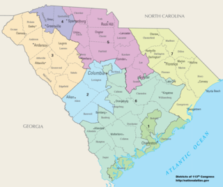
There are currently seven United States congressional districts in South Carolina. There have been as few as four and as many as nine congressional districts in South Carolina. The 9th district and the 8th district were lost after the 1840 Census. Because the state exceeded the nation's average population growth in the 2010 Census, South Carolina regained its 7th district, which had remained unused since the Civil War.

South Carolina Highway 6 is a 115-mile (185 km) state highway that extends from Moncks Corner in Berkeley County to Ballentine in Richland County, near Irmo. It uniquely links all three of the major hydropower projects in South Carolina: Lake Murray, Lake Marion and Lake Moultrie.
Ballentine is an unincorporated community in Richland County, South Carolina, United States. It is part of the Columbia, South Carolina metropolitan area.
Nathan Ballentine is a Republican member of the South Carolina House of Representatives, United States, representing the House District 71 since 2005.

As defined by the U.S. Office of Management and Budget, and used by the U.S. Census Bureau for statistical purposes only, the Columbia metropolitan statistical area, is an area consisting of six counties in central South Carolina, anchored by the city of Columbia. The current population has an estimation of 837,092. It is the second-largest metropolitan statistical area in the state of South Carolina, since the Anderson metropolitan statistical area was combined with Greenville's following the 2010 census.
White Rock is an unincorporated community in northwestern Richland County, South Carolina, United States, a few miles north of Lake Murray. Although it is unincorporated, it has a post office, with the ZIP Code of 29177. The population of the ZCTA for ZIP Code 29177 was 463 at the outdated 2000 census. The Lowman Home retirement home was established in 1911. Nearby is the Lake Murray Golf Center Nine-Hole Par 3 driving range, and mini golf. In the 21st century, the White Rock area has been transformed by the addition and expansion of several subdivisions, Waterfall, Portrait Hill, Lake Murray Elementary, the new Chapin Middle School, Spring Hill High School, home to Lake Murray Docks and the Center for Advanced Technical Studies, all in Lexington & Richland County School District Five.

The Lake Murray Symphony Orchestra (LMSO) is an American symphony orchestra based in Columbia, South Carolina.
Chapin High School is a public high school in Chapin, South Carolina. Nearly 1,400 students attend Chapin High School, as of the 2017-2018 school year. Chapin High School is one of four high schools in Lexington & Richland County School District Five.


