
The Zambezi is the fourth-longest river in Africa, the longest east-flowing river in Africa and the largest flowing into the Indian Ocean from Africa. Its drainage basin covers 1,390,000 km2 (540,000 sq mi), slightly less than half of the Nile's. The 2,574 km (1,599 mi) river rises in Zambia and flows through eastern Angola, along the north-eastern border of Namibia and the northern border of Botswana, then along the border between Zambia and Zimbabwe to Mozambique, where it crosses the country to empty into the Indian Ocean.

Copperbelt Province is a province in Zambia which covers the mineral-rich Copperbelt, and farming and bush areas to the south. It was the backbone of the Northern Rhodesian economy during British colonial rule and fuelled the hopes of the immediate post-independence period, but its economic importance was severely damaged by a crash in global copper prices in 1973. The province adjoins the Haut-Katanga province of the Democratic Republic of the Congo, which is similarly mineral-rich.
Chavuma Falls is a small waterfall on the Zambezi River in northwestern Zambia close to the town of Chavuma, lying immediately south of the border with Angola. During the wet season, the waterfalls are generally overwhelmed by the flow of the river but become visible as the dry season progresses. The falls have a mean annual discharge of 555 m3/s and are only a few meters high. In 2018, Zambia proposed to develop a hydroelectric power station at Chavuma Falls to boost energy production and stimulate economic activities in the area.
Kabompo is a town in north-western Zambia, lying on the Kabompo River with a population over 88,000 people. It is surrounded by teak forest and is home to a Roman Catholic mission. Kabompo was founded in the 1900s or even earlier than that, the district centre was first situated in Nkulwashi before it was moved to its current location. The district boasts of its significance towards its contribution to the nation's food security through Food Reserve Agency (FRA). Even in the late 60's and early 70's Kabompo was very active in agricultural activities through NAMBOARD.

Chavuma is a town in the North-Western Province of Zambia, lying immediately south of the border with Angola. The town is approximately 1,100 kilometers from Lusaka and 11 kilometers from the Angolan border town of Kalipande. It lies on the Zambezi River. Local attractions include the Chavuma Falls, while a market takes place on the border, permitting people from both nations to trade.

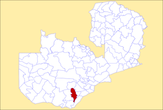
Kabwe District is a district of Zambia, located in Central Province. The capital lies at Kabwe. As of the 2010 Zambian Census, the district had a population of 299,206 people. It consists of two constituencies, namely Kabwe Central and Bwacha.

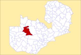
Kapiri Mposhi District is a district of Zambia, located in Central Province. The capital lies at Kapiri Mposhi. As of the 2022 Zambian Census, the district had a population of 371,068 people.
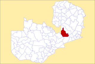
Serenje District is a district of Zambia, located in Central Province. The capital lies at Serenje. As of the 2022 Zambian Census, the district had a population of 158,192 people. It consists of two constituencies, namely Serenje and Muchinga. The district contains Lake Lusiwasi.

Luanshya District is a district of Zambia, located in Copperbelt Province. The capital lies at Luanshya. As of the 2022 Zambian census, the district had a population of 211,966 people.

Kabompo District is a district of Zambia, located in North-Western Province. The capital lies at Kabompo. As of the 2022 Zambian Census, the district had a population of 65,760 people.

Kasempa District is a district of Zambia, located in North-Western Province. The capital lies at Kasempa. As of the 2022 Zambian Census, the district had a population of 111,272 people.
Mufumbwe District is a district of Zambia, located in North-Western Province. The capital lies at Mufumbwe. As of the 2022 Zambian Census, the district had a population of 98,217 people.

Zambezi District is a district of Zambia, located in North-Western Province. The capital lies at Zambezi. As of the 2022 Zambian Census, the district had a population of 108,220 people. It consists of two constituencies, namely Zambezi West and Zambezi East.
Choma District is a district of Zambia, located in Southern Province. The capital lies at Choma. As of the 2022 Zambian Census, the district had a population of 266,916 people. Choma has been the provincial capital of the Southern Province since 2012.

Monze District is a district of Zambia, located in Southern Province. The capital lies at Monze. As of the 2022 Zambian Census, the district had a population of 268,432 people.

Sinazongwe District is a district of Zambia, located in Southern Province. The capital lies at Sinazongwe. As of the 2022 Zambian Census, the district had a population of 159,055 people.

Mpongwe District is a district of Zambia, located in Copperbelt Province. The capital lies at Mpongwe. As of the 2022 Zambian Census, the district had a population of 135,486 people.

Chavuma is a constituency of the National Assembly of Zambia. It covers 13 wards, including the town of Chavuma and the surrounding rural area in Chavuma District of North-Western Province.

Shibuyunji District, also known as Sibuyunji District, is a district of Central Province, Zambia.
