
The Kafue River is the longest river lying wholly within Zambia at about 1,576 kilometres (979 mi) long. Its water is used for irrigation and for hydroelectric power. It is the largest tributary of the Zambezi, and of Zambia's principal rivers, it is the most central and the most urban. More than 50% of Zambia's population live in the Kafue River Basin and of these around 65% are urban.

Kafue National Park is the largest national park in Zambia, covering an area of about 22,400 km2. It is one of the largest parks in Africa and is home to 152 different species of mammals.

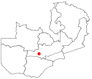
The Itezhi-Tezhi Dam on the Kafue River in west-central Zambia was built between 1974 and 1977 at the Itezhi-Tezhi Gap, in a range of hills through which the river had eroded a narrow valley, leading to the broad expanse of the wetlands known as the Kafue Flats. The town of Itezhi-Tezhi is to the east side of the dam.
Mumbwa is a town in the Central Province of Zambia, lying on the M9 Road. Its district covers the western part of the Central Province bordering Kaoma and Western Province to the west, Namwala and Southern Province to the south, Lusaka and Lusaka Province to the east, Kasempa and North-Western Province to the north and Kabwe to the north-east. It is known for its cotton and has a ginnery. The Zambia Air Force has a base in the district. Kafue National Park borders the district to the west. The predominant tribes are the Ila, who speak a dialect known as Sala, mostly to the south and south east and the Kaonde to the north. The Lenje are to the north-east on the border area with Kabwe. There are also relatively large settlement of people from the west and north west such as the Lozi, Nkoya and Luvale, Shona people from the then Southern Rhodesia who settled there as refugees from the civil war in that country and who are now almost integrated and Tonga from the south. A lot of prospecting for minerals such as copper and gold was done in the district and small scale mines operated there. Most are now closed, though the gold mine at Luiri has been revived.
Kasempa Town is a developing small town located in North-Western Province, Zambia. It is approximately 550 kilometres (340 mi) by road northwest of Lusaka, the capital. Kasempa Town is located on the western bank of the Lufupa River as it flows south into the Kafue National Park.
Kaoma is a town in Zambia. It is the headquarters of Kaoma District in the Western Province and is located on the M9 Road.
Ngoma, Zambia is the only settlement in the south of Kafue National Park. It is a short way south of Itezhi-Tezhi Dam. Ngoma is the home of the head warden for the south half of the park, and for around 200 game wardens and their families employed by ZAWA. There is a small information centre about the local wildlife, and in the village is Ngoma Basic School.

Central Province is one of Zambia's ten provinces. The provincial capital is Kabwe, which is the home of the Mulungushi Rock of Authority. Central Province has an area of 94,394 km (58,654 mi). It borders eight other provinces and has eleven districts. The total area of forest in the province is 9,095,566 ha, and it has a national park and three game management areas. The first mine in the region was opened up in 1905 making the then Broken Hill town the first mining town. In 1966, he town's name was reverted to its indigenous name - Kabwe meaning 'ore' or 'smelting'.

Lusaka Province is one of the ten provinces of Zambia. Its capital is Lusaka, which is also the national capital. It is the smallest province in Zambia, with an area of 21,896 km2. Lusaka is also Zambia's most populated and most densely populated province, with a population of 2,191,225 and density of 100 persons per km2 as of 2010. It is the most urban province, with the most doctors and fewest malaria-related incidents. The province is bordered by Zimbabwe and Mozambique, and separated by the Lower Zambezi National Park.

Southern Province is one of Zambia's ten provinces, and home to Zambia's premier tourist attraction, Mosi-oa-Tunya, shared with Zimbabwe. The centre of the province, the Southern Plateau, has the largest area of commercial farmland of any Zambian province, and produces most of the maize crop.
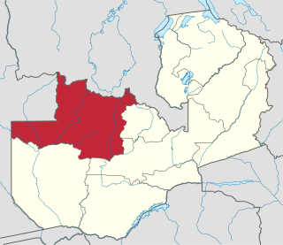
North-Western Province is one of ten Provinces of Zambia. It covers an area of 125,826 km2 (48,582 sq mi), has a population of 727,044 and a population density was 5.80 per square kilometre as of 2010. It is the most sparsely populated province in the country. The provincial capital is Solwezi. The literacy rate stood at 63 per cent against a national average of 70.2 per cent. The rural population constituted 77.45%, while the urban population was 22.55%. North-Western Province is bordered along Angola in the west, the Democratic Republic of Congo in the north, Copperbelt Province in the east, Central in the south-east, and Western Province in the south-west.
The Kafue Flats are a vast area of swamp, open lagoon and seasonally inundated flood-plain on the Kafue River in the Southern, Central and Lusaka provinces of Zambia. They are a shallow flood plain 240 km long and about 50 km wide, flooded to a depth of less than a meter in the rainy season, and drying out to a clayey black soil in the dry season.

Lukanga Swamp is a major wetland in the Central Province of Zambia, about 50 km west of Kabwe. Its permanently swampy area consists of a roughly circular area with a diameter of 40 to 50 km covering 1850 km2, plus roughly 250 km2 in the mouths of and along rivers discharging into it such as the Lukanga River from the north-east, plus another 500 km2 either side of the Kafue River to the west and north-west, making 2600 km2 in total. It contains many lagoons such as Lake Chiposhye and Lake Suye but few large channels, and its average depth is only 1.5 m.
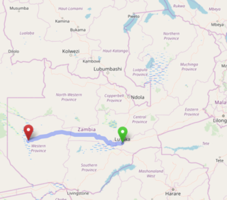
The Lusaka–Mongu Road of Zambia runs 580 km from the capital, Lusaka, to Mongu, capital of the Western Province. It connects that province to the rest of the country, as well as being one of two routes to the south-west extremity of North-Western Province. It also serves as the main highway of the western half of Central Province. The entire route from Lusaka to Mongu is designated as the M9 Road.

The T1 or Lusaka–Livingstone Road is the main highway of the Southern Province of Zambia. It begins 55 kilometres south of the city of Lusaka and heads south-west to the principal tourist destination, Victoria Falls in Livingstone, Southern Africa, measuring approximately 430 kilometres (267 mi). The entire route is part of Trans-African Highway network number 4 or Cairo-Cape Town Highway between Cairo and Cape Town.
Itezhi-Tezhi is a small town in the Southern Province of Zambia. It is the seat of the Itezhi-Tezhi District. It lies west of the town of Namwala on the border of the Kafue National Park.

Itezhi-Tezhi District is a district of Zambia, located in Southern Province. The capital lies at Itezhi-Tezhi. As of the 2000 Zambian Census, the district had a population of 43111 people.

Namwala District is a district of Zambia, located in Southern Province. The capital lies at Namwala. As of the 2000 Zambian Census, the district had a population of 82,810 people.
The M11 Road is a road in the Southern Province of Zambia that connects Choma with Namwala. It is the main road connecting Namwala to the rest of the Southern Province. It is approximately 169 kilometres in length.
