
Copperbelt Province is a province in Zambia which covers the mineral-rich Copperbelt, and farming and bush areas to the south. It was the backbone of the Northern Rhodesian economy during British colonial rule and fuelled the hopes of the immediate post-independence period, but its economic importance was severely damaged by a crash in global copper prices in 1973. The province adjoins the Haut-Katanga province of the Democratic Republic of the Congo, which is similarly mineral-rich.

Northern Province is one of Zambia's ten provinces. It covers approximately one-sixth of Zambia in land area. The provincial capital is Kasama. The province is made up of 12 districts, namely Kasama District, Chilubi District, Kaputa District, Luwingu District, Mbala District, Mporokoso District, Mpulungu District, Mungwi District, Nsama District, Lupososhi District, Lunte District and Senga Hill District. Currently, only Kasama and Mbala have attained municipal council status, while the rest are still district councils. It is widely considered to be the heartland of the Bemba, one of the largest tribes in Zambia.

Luapula Province is one of Zambia's ten provinces located in the northern part of the country. Luapula Province is named after the Luapula River and its capital is Mansa. As per the 2022 Zambian census, the Province had a population of 1,519,478, which accounted for 7.72 per cent of the total Zambian population.

Chama District with the headquarters at Chama is the largest district of the Eastern Province in Zambia and includes a large wilderness in the Upper Luangwa valley just north-east of the North Luangwa National Park. It is made up of two constituencies, namely Chama North and Chama South.

Chibombo District is a district of Central Province, Zambia. As of the 2022 Zambian Census, the district had a population of 421,315 people. It consists of two constituencies, namely Keembe and Katuba.

Chinsali District with headquarters at Chinsali is located in Muchinga Province, Zambia.

Kaoma District with headquarters at Kaoma, Zambia is located in the north-eastern corner of Western Province. As of the 2022 Zambian Census, the district had a population of 146,690 people. The population lives mainly around Kaoma town and the northern parts of the district along the Luena and Luampa rivers. Its south-western portion is relatively uninhabited being very sandy with little water available in the dry season.

Kalabo District is a district of Zambia, located in Western Province. The capital lies at Kalabo. As of the 2022 Zambian Census, the district had a population of 111,769 people. The district contains the Liuwa Plain National Park.
Serenje District is a district of Zambia, located in Central Province. The capital lies at Serenje. As of the 2022 Zambian Census, the district had a population of 158,192 people. It consists of two constituencies, namely Serenje and Muchinga. The district contains Lake Lusiwasi.

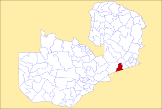
Chililabombwe District is a district of Zambia, located in Copperbelt Province. The capital is Chililabombwe. At the 2022 Zambian Census, the district had a population of 141,899.

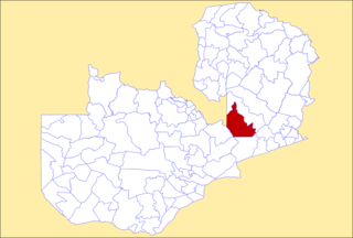
Ndola District is a district of Zambia, located in Copperbelt Province. The capital lies at Ndola. As of the 2022 Zambian Census, the district had a population of 624,579 people.

Kasempa District is a district of Zambia, located in North-Western Province. The capital lies at Kasempa. As of the 2022 Zambian Census, the district had a population of 111,272 people.

Gwembe District is a district of Zambia, located in Southern Province. The capital now lies at Munyumbwe. As of the 2022 Zambian Census, the district had a population of 79,273 people.
Petauke District is a district of Zambia, located in Eastern Province. The capital lies at Petauke. As of the 2022 Zambian Census, the district had a population of 259,385 people. It consists of two constituencies, namely Petauke Central and Kaumbwe.

Mwense District is a district of Zambia, located in Luapula Province. The capital lies at Mwense. As of the 2022 Zambian Census, the district had a population of 122,605 people. It consists of two constituencies, namely Mwense and Mambilima.

Isoka District is a district of Zambia, located in Muchinga Province. The capital lies at Isoka. As of the 2022 Zambian Census, the district had a population of 111,599 people.

Kaputa District is a district of Zambia, located in Northern Province. The capital lies at Kaputa. As of the 2022 Zambian Census, the district had a population of 102,854 people.

Mbala District is a district of Zambia, located in Northern Province. The capital lies at Mbala. As of the 2022 Zambian Census, the district had a population of 161,595 people.

Muchinga Province is one of the ten provinces of Zambia. It is located in the northeast of the country and borders with Tanzania in the north, Malawi in the east, Eastern Province in the south, Central Province in the southwest, Luapula Province in the west, and Northern Province in the northwest. The administrative center of the province is Chinsali.

Chisamba District is a district of Central Province, Zambia. It covers a total surface area of 5,204.5 sq km and is known for its agricultural activities with over 32,000 small scale farming families and 256 commercial farmers, the majority of whom are white Zambians. It shares borders with Lusaka, Chongwe, Chibombo, Kabwe, Kapiri Mposhi and Luano Districts. As of the 2022 Zambian Census, the district had a population of 160,828 people.
