
Zambia is a developing country, and it achieved middle-income status in 2011. Through the first decade of the 21st century, the economy of Zambia was one of the fastest-growing economies in Africa, and its capital, Lusaka, the fastest-growing city in the Southern African Development Community (SADC). Zambia's economic performance has stalled in recent years due to declining copper prices, significant fiscal deficits, and energy shortages.

Kafue is a town on the T2 road in the Lusaka Province of Zambia and it lies on the north bank of the Kafue River, after which it is named. It is the southern gateway to the central Zambian plateau on which Lusaka and the mining towns of Kabwe and the Copperbelt are located.

Copperbelt Province is a province in Zambia which covers the mineral-rich Copperbelt, and farming and bush areas to the south. It was the backbone of the Northern Rhodesian economy during British colonial rule and fuelled the hopes of the immediate post-independence period, but its economic importance was severely damaged by a crash in global copper prices in 1973. The province adjoins the Haut-Katanga province of the Democratic Republic of the Congo, which is similarly mineral-rich.

Kapiri Mposhi is a Zambian town and the seat of the Kapiri Mposhi District in Central Province. Located north of Lusaka, it stands on the Great North Road and is significant for the railway connection between the Zambia Railways line from Kitwe to Lusaka and the western terminus of the Tanzania-Zambia Railway Authority from Dar es Salaam since 1976.

Chavuma is a town in the North-Western Province of Zambia, lying immediately south of the border with Angola. The town is approximately 1,100 kilometers from Lusaka and 11 kilometers from the Angolan border town of Kalipande. It lies on the Zambezi River. Local attractions include the Chavuma Falls, while a market takes place on the border, permitting people from both nations to trade.
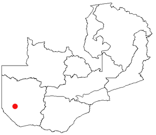
Senanga is the capital of the Senanga District, which is located in the Western Province of Zambia. The town is situated on the eastern bank of the Zambezi River, at the southern end of the Barotse Floodplain. It lies on the main road running parallel to the river from Livingstone and Sesheke to Mongu. Recently the Kaunga Lyeti Bridge was completed to cross the Kaunga Lyeti River near the junction to Sioma, traveling from Sesheke and Katima Mulilo. On top of the bridgework, recent road projects have improved travel conditions and inspired economic confidence and growth.

Central Province is one of Zambia's ten provinces. The provincial capital is Kabwe, which is the home of the Mulungushi Rock of Authority. Central Province has an area of 94,394 km (58,654 mi). It borders eight other provinces and has eleven districts. The total area of forest in the province is 9,095,566 ha, and it has a national park and three game management areas. The first mine in the region was opened up in 1905 making the then Broken Hill town the first mining town. In 1966, the town's name was reverted to its indigenous name - Kabwe meaning 'ore' or 'smelting'.

Southern Province is one of Zambia's ten provinces. It is home to Zambia's premier tourist attraction, Mosi-oa-Tunya, shared with Zimbabwe. The centre of the province, the Southern Plateau, has the largest area of commercial farmland of any Zambian province, and produces most of the maize crop.
The Kafue Flats are a vast area of swamp, open lagoon and seasonally inundated flood-plain on the Kafue River in the Southern, Central and Lusaka provinces of Zambia. They are a shallow flood plain 240 km (150 mi) long and about 50 km (31 mi) wide, flooded to a depth of less than a meter in the rainy season, and drying out to a clayey black soil in the dry season.

Misisi Compound is a shanty town or komboni located in Lusaka, Zambia. In 2008, it was estimated to have 10,000 inhabitants. Plans for redevelopment were announced by President Edgar Lungu in 2019.

Zambia National Commercial Bank, commonly referred to by the name "Zanaco", is a commercial bank in Zambia. It is licensed by Bank of Zambia, the central bank and national banking regulator. In 2021, Zanaco became the first bank in Zambia to register ZMW1bn in profit after tax.
Chisamba is a small town located near Chibombo, in the Central Province of Zambia. It is located roughly 60 miles (97 km) north of Lusaka. In February 2013 a bus crash killed 53 people near Chisamba. The Protea Hotel Safari Lodge Hotel is located in Chisamba.

Chibombo District is a district of Central Province, Zambia. As of the 2022 Zambian Census, the district had a population of 421,315 people. It consists of two constituencies, namely Keembe and Katuba.

Kaputa District is a district of Zambia, located in Northern Province. The capital lies at Kaputa. As of the 2022 Zambian Census, the district had a population of 102,854 people.
The diocese of Kabwe is a diocese of the Roman Catholic Church located in Kabwe, Zambia.
The proposed Batoka Gorge Hydroelectric Power Station is a 2400 MW hydroelectric power station, planned for the Zambezi River on the international border between Zambia and Zimbabwe.
Tourism in Zambia relates to tourism in the African nation Zambia. The tourism industry is a major and growing industry in Zambia. Zambia has more than 2500 lions along with several National parks, waterfalls, lakes, rivers, and historic monuments. Zambia has been involved in several agreements on tourism with nations like Uganda and Kenya. Uganda Ministry of Tourism and Arts said Zambia is a model in tourism in Africa. Zambia Tourism Agency (ZTA) has partnered with the Government through the Ministry of Tourism and private sector to enhance the marketing aspect in the tourism industry.

Katuba is a constituency of the National Assembly of Zambia. It covers the rural area to the north-west of Lusaka in the Chibombo District of Central Province.

The T2 is a trunk road in Zambia. The road runs from the Tunduma border with Tanzania via Mpika, Kabwe and Lusaka to the Chirundu border with Zimbabwe. The road is the longest route of the country, as it is approximately 1,155 kilometres (718 mi). The route from Mpika to Kafue is a toll road. The route from Tanzania to Lusaka is Zambia's Great North Road and is part of the Tanzam Highway.

Chitambo District is a district of Central Province, Zambia. It was separated from Serenje District in 2012 and is located some 357km north-east of Kabwe along the Great North Road. As of the 2022 Zambian Census, the district had a population of 100,603 people.
