
The Luapula River is a north-flowing river of central Africa, within the Congo River watershed. It rises in the wetlands of Lake Bangweulu (Zambia), which are fed by the Chambeshi River. The Luapula flows west then north, marking the border between Zambia and the Democratic Republic of the Congo before emptying into Lake Mweru. The river gives its name to Zambia's Luapula Province.
Mufulira is a town in the Copperbelt Province of Zambia. Mufulira means "Place of Abundance and Peace". The town developed around the Mufulira Copper Mine in the 1930s. The town also serves as the administrative capital of Mufulira District.
Nchelenge is a town in the Luapula Province of northern Zambia, lying on the south eastern shore of Lake Mweru. It is contiguous with Kashikishi, and they are sometimes referred to as Nchelenge-Kashikishi. Nchelenge is the administrative centre for the Zambian part of Lake Mweru, being the seat of the district government and branches of national agencies, while Kashikishi is the market and fisheries centre. Nchelenge attained District status in 1997 when it was upgraded from being a sub-District structure of the Kawambwa District in Luapula.
Kawambwa is a town in the Zambian province of Luapula located on the edge of the northern Zambian plateau above the Luapula valley at an altitude of 1300 m. It was chosen as an administrative district of the same name by the British colonial authorities who preferred the climate of the plateau rather than the hotter valley where most of the district's population live, and it continues as an administrative district today.

Mansa is the capital of the Luapula Province of Zambia, and headquarters of Mansa District. It takes its name from the local Chief Mansa and the small Mansa River which flows west to the Luapula River. During British rule the city was named Fort Rosebery.

Luapula Province is one of Zambia's ten provinces located in the northern part of the country. Luapula Province is named after the Luapula River and its capital is Mansa. As per the 2022 Zambian census, the Province had a population of 1,519,478, which accounted for 7.72 per cent of the total Zambian population.

The ten provinces of Zambia are divided into a total of 116 districts as of 2018.
Kashikishi is a town on the south-eastern shore of Lake Mweru in the Luapula Province of Zambia. It lies just north of the district headquarters Nchelenge, and close enough for them to be considered twin towns; they are sometimes referred to as Nchelenge–Kashikishi.
Kazembe is a name used for Mwata Kazembe's town in the Luapula Province of Zambia, especially on maps and in the Zambian postal service. The other name for the town is Mwansabombwe and this is the one used by its or Luba or Chibemba-speaking inhabitants. They may refer in English to "Kazembe's Village" or just "Kazembe", as traditionally a settlement is named after the chief or headman, rather than the location. The Luba-Lunda shared with many tribes the custom of moving to another village or a new site on the death of the chief. Historical references to a village or town may actually be to a different location. For instance when the explorer David Livingstone visited Mwata Kazembe in 1867 and 1868, "Casembe's town", as he wrote it, was further north at the town now called Kanyembo.
Kanyembo is the principal centre of the population on the Mofwe Lagoon, the largest of several lagoons in the Luapula River swamps south of Lake Mweru, in the Luapula Province of Zambia. It takes its name from its traditional ruler, Chief Kanyembo, one of the senior chiefs of the Kazembe-Lunda under Mwata Kazembe. In the past the incumbent Chief has been promoted to Mwata, and Kanyembo was the site of Mwata Kazembe's capital when it was visited by David Livingstone in 1867.

The Congo Pedicle road crosses the Congolese territory of the Congo Pedicle and was constructed by and is maintained by Zambia to connect its Copperbelt and Luapula Provinces. Both the road and the territory may be referred to as ‘the Pedicle’. It is designated as the N36 Route on the Congolese Road Network.
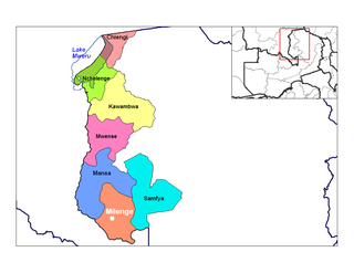
Milenge is a settlement in the Luapula Province of Zambia, and headquarters of Milenge District. It consists of the boma housing the district council and offices, with a village of a few thousand people on the dirt road which runs from Chembe in the west.
Chembe is a border town in Chembe District in the Luapula Province of Zambia. It once had the Chembe Ferry as a means of crossing the Luapula River from DR Congo to Zambia; but now, it is the home of the Mwanawasa Bridge, named after former president Levy Mwanawasa. The Mwanawasa Bridge connects the M3 road to the Congo Pedicle road, a dirt highway maintained by Zambia through Congolese territory to link Mansa to the Copperbelt.

Chiengi District with headquarters at Chiengi is the smallest and most northerly district in the Luapula Province of Zambia and was carved out of Nchelenge District after Zambia's independence. As of the 2022 Zambian Census, the district had a population of 189,893 people. Most of its population live in fishing villages along the 70 km (approx.) of the north-east shore of Lake Mweru which lies within the district. The largest settlement is Puta, 5 km south of Chiengi town, named after Chief Puta. The district is bounded by the DR Congo border in the north, Kaputa District in the east and the Kalungwishi River in the south.

Mansa District with headquarters at Mansa is a district located in Luapula Province. As of the 2022 Zambian Census, the district had a population of 327,063 people. It consists of two constituencies, namely Mansa Central and Bahati.

Samfya District is located in Luapula Province, Zambia. The headquarters is at Samfya.

Chembe District is a district of Zambia, located in Luapula Province. The capital lies at Chembe. It was created in 2012 by splitting Mansa District.
The M4 road is a road in the Copperbelt Province of Zambia. The road connects the city of Ndola with the city of Mufulira and extends to connect Mufulira with the city of Kitwe. As it is a v-shaped route, the M4 road starts and ends at a junction with the T3 road.
The M3 road is a road in northern Zambia that connects Kasama in the Northern Province with the Congo Pedicle border at Chembe in the Luapula Province via Luwingu and Mansa. The road contains two tollgates between Kasama and Mansa.
