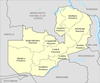
Zambia is divided into 10 provinces for administrative purposes. Each province is headed by a minister appointed by the President and there are ministries of central government for each province. The administrative head of each province is the Permanent Secretary, appointed by the President. There are Deputy Permanent Secretary, heads of government departments and civil servants at the provincial level.

Copperbelt Province is a province in Zambia which covers the mineral-rich Copperbelt, and farming and bush areas to the south. It was the backbone of the Northern Rhodesian economy during British colonial rule and fuelled the hopes of the immediate post-independence period, but its economic importance was severely damaged by a crash in global copper prices in 1973. The province adjoins the Haut-Katanga province of the Democratic Republic of the Congo, which is similarly mineral-rich.

Kapiri Mposhi is a Zambian town and the seat of the Kapiri Mposhi District in Central Province. Located north of Lusaka, it stands on the Great North Road and is significant for the railway connection between the Zambia Railways line from Kitwe to Lusaka and the western terminus of the Tanzania-Zambia Railway Authority from Dar es Salaam since 1976.

The ten provinces of Zambia are divided into a total of 116 districts as of 2018.

Lufwanyama is a small town on the M18 Road in the Copperbelt Province of Zambia.

Chibombo District is a district of Central Province, Zambia. As of the 2010 Zambian Census, the district had a population of 293,765 people. It consists of two constituencies, namely Keembe and Katuba.

Kapiri Mposhi District is a district of Zambia, located in Central Province. The capital lies at Kapiri Mposhi. As of the 2010 Zambian Census, the district had a population of 240,638 people.

Chililabombwe District is a district of Zambia, located in Copperbelt Province. The capital is Chililabombwe. At the 2010 Zambian Census, the district had a population of 91,833.

Chingola District is a district of Zambia, located in Copperbelt Province. The capital lies at Chingola. As of the 2010 Zambian Census, the district had a population of 216,626 people. It is divided into two constituencies, namely Chingola constituency and Nchanga constituency.

Kitwe District is a district of Zambia, located in Copperbelt Province. The capital is Kitwe. As of the 2000 Zambian Census, the district had a population of 376,124 people.

Masaiti District is a district of Zambia, located in Copperbelt Province. The capital lies at Masaiti. As of the 2000 Zambian Census, the district had a population of 95,581 people. It is divided into two constituencies, namely Masaiti constituency and Kafulafuta constituency.

Mpongwe District is a district of Zambia, located in Copperbelt Province. The capital lies at Mpongwe. As of the 2010 Zambian Census, the district had a population of 93,380 people.
Kafulafuta is a constituency of the National Assembly of Zambia. It covers the towns of Chondwe, Mubanga and Walamba in Masaiti District of Copperbelt Province.
Lufwanyama is a constituency of the National Assembly of Zambia. It covers a large rural area in the Lufwanyama District of Copperbelt Province, including the town of Lufwanyama.
Masaiti is a constituency of the National Assembly of Zambia. It covers the towns of Masaiti and Milomwe in Copperbelt Province.
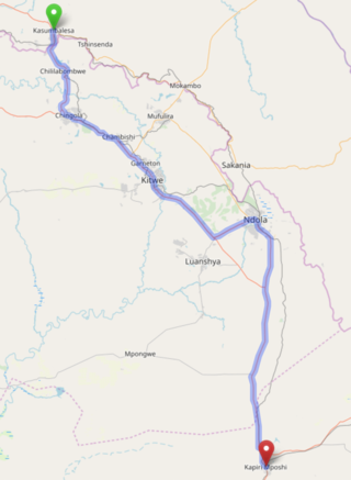
The T3 is a Trunk Road in Zambia. The road runs from Kapiri Mposhi via Ndola, Kitwe and Chingola to Kasumbalesa on the border with DR Congo. The route is a toll road from Kapiri Mposhi to just after Kitwe.

Kafubu River is a river in the Copperbelt Province of Zambia. It starts in Ndola and it cuts through the city's main area westwards into the area in-between Levy Mwanawasa Stadium and Masala before turning southwards after Masala and continuing through the Luanshya and Masaiti districts to join the Kafue River.
The T5 is a trunk road in Zambia. It connects Chingola in the Copperbelt Province with Solwezi and Mwinilunga in the North-Western Province. The Route extends to end at the Jimbe border post with Angola. It is the only other road after the M18 Road that connects the towns of the North-Western and Copperbelt provinces and is currently one of the main routes motorists use to reach Angola from Zambia. The first section of the road is a toll road.
The M8 Road is a road in the North-Western Province of Zambia. It connects Mutanda in Solwezi District with Zambezi Town via Mufumbwe, Manyinga & Kabompo.
The M18 Road is a road in Zambia that connects Kitwe in the Copperbelt Province with Kasempa in the North-Western Province via Kalulushi and Lufwanyama. It is the only other road after the T5 Road that connects the towns of the North-Western and Copperbelt provinces. The section from Kitwe to Kalulushi is designated as the M7 Road while the remainder of the route from Kalulushi westwards is designated as the M18 Road on Zambia's road network.
