
Western Province is one of the 10 provinces in Zambia and encompasses most of the area formerly known as Barotseland. The capital is Mongu, and together with the neighbouring town of Limulunga, Mongu is treated as the capital of Barotseland.

Pemba is a port city and district in Mozambique. It is the capital and largest city of the Cabo Delgado province and lies on a peninsula in Pemba Bay, the third largest in Africa. It is located northeast of Maputo, Mozambique's capital.

Northern Province is one of Zambia's ten provinces. It covers approximately one-sixth of Zambia in land area. The provincial capital is Kasama. The province is made up of 12 districts, namely Kasama District, Chilubi District, Kaputa District, Luwingu District, Mbala District, Mporokoso District, Mpulungu District, Mungwi District, Nsama District, Lupososhi District, Lunte District and Senga Hill District. Currently, only Kasama and Mbala have attained municipal council status, while the rest are still district councils. It is widely considered to be the heartland of the Bemba, one of the largest tribes in Zambia.
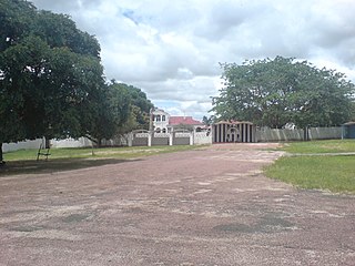
Mongu is the capital of Western Province in Zambia and was the capital of the formerly-named province and historic state of Barotseland. Its population is 179,585, and it is also the headquarters of Mongu District. Mongu is the home of the Litunga, King of the Lozi people.

Kalabo is an urban centre and the seat of Kalabo District, in the Western Province of Zambia.

Lusaka Province is one of the ten provinces of Zambia. It is the smallest in terms of land area, covering 21,896 km2. However, it is the most populated and densely populated province in Zambia, with a population of 3,079,964 as of 2022 and a population density of 140 persons per km2.

Southern Province is one of Zambia's ten provinces. It is home to Zambia's premier tourist attraction, Mosi-oa-Tunya, shared with Zimbabwe. The centre of the province, the Southern Plateau, has the largest area of commercial farmland of any Zambian province, and produces most of the maize crop.
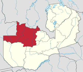
North-Western Province is one of ten Provinces of Zambia. It covers an area of 125,826 km2 (48,582 sq mi), has a population of 1,278,357 and a population density of 20 per square kilometre as of 2021. It is the most sparsely populated province in the country. The provincial capital is Solwezi. The literacy rate stood at 63 per cent in 2010 against a national average of 70.2 per cent. The rural population constituted 77.45%, while the urban population was 22.55%. North-Western Province is bordered along Angola in the west, the Democratic Republic of Congo in the north, Copperbelt Province in the east, Central in the south-east, and Western Province in the south-west.

The ten provinces of Zambia are divided into a total of 116 districts as of 2018.

The Luena River of Zambia's Western Province rises just west of the Kafue National Park and flows west through Kaoma to become a tributary of the Zambezi. In the dry season, just below its confluence with its seasonal tributary the Luampa River, it ends in swamps or marshes on the Luena Flats east of Lukulu. In the wet season the Luena Flats flood and overflow into the Ndandu channel or floodplain which leads south-west to the Barotse Floodplain of Zambezi north of Limulunga and Mongu. It is the widest 'tributary' floodplain of the Barotse Floodplain, reaching 20 kilometres (12 mi) wide at its mouth.

Chilubi District with headquarters at Chilubi is located in Northern Province, Zambia. It covers the north-east Lake Bangweulu and Bangweulu Wetlands containing several islands including Chilubi Island, and some of the mainland northeast of the lake. As of the 2022 Zambian Census, the district had a population of 114,011 people.
The biomes and ecoregions in the ecology of Zambia are described, listed and mapped here, following the World Wildlife Fund's classification scheme for terrestrial ecoregions, and the WWF freshwater ecoregion classification for rivers, lakes and wetlands. Zambia is in the Zambezian region of the Afrotropical biogeographic realm. Three terrestrial biomes are well represented in the country . The distribution of the biomes and ecoregions is governed mainly by the physical environment, especially climate.
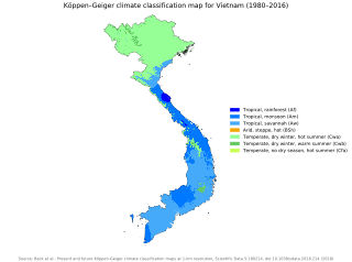
Vietnam has a monsoon-influenced climate typical of that of mainland Southeast Asia. The diverse topography, long latitude, and influences from the South China Sea lead to climatic conditions varying significantly between regions. The northern region experiences a monsoonal and temperate climate (Cfa) with four distinct seasons with winters typically dry and summers ranging from hot to mild. In southern and central areas, the climate is tropical monsoon (Aw) with only two seasons. In addition, a temperate climate exists in mountainous areas, which are found in Sa Pa and Da Lat, while a more continental climate exists in Lai Châu Province and Sơn La Province.

Kawambwa District is a district of Zambia, located in Luapula Province. The capital lies at Kawambwa, which lies at the intersection of three roads: D19, M13, and Kawambwa-Mbereshi. As of the 2022 Zambian Census, the district had a population of 123,652 people. It consists of two constituencies, namely Kawambwa and Pambashe.

Kaputa District is a district of Zambia, located in Northern Province. The capital lies at Kaputa. As of the 2022 Zambian Census, the district had a population of 102,854 people.

Mporokoso District is a district of Zambia, located in Northern Province. The capital lies at Mporokoso. As of the 2022 Zambian Census, the district had a population of 63,452 people.
Mpulungu District is a district of Zambia, located in Northern Province. The capital lies at Mpulungu. As of the 2022 Zambian Census, the district had a population of 153,564 people.

Muchinga Province is one of the ten provinces of Zambia. It is located in the northeast of the country and borders with Tanzania in the north, Malawi in the east, Eastern Province in the south, Central Province in the southwest, Luapula Province in the west, and Northern Province in the northwest. The administrative center of the province is Chinsali.

Manyinga District is a district of North-Western Province, Zambia. It was separated from Kabompo District in 2012. As of the 2022 Zambian Census, the district had a population of 75,030 people.

Lupososhi District is a district of Northern Province, Zambia. It was created in 2018 by splitting Luwingu District. As of the 2022 Zambian Census, the district had a population of 79,614 people.
