This article is about the Transport in Zambia.
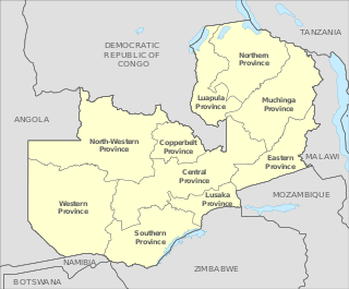
Zambia is divided into ten provinces. The provinces are further subdivided into districts. The Provincial Administration is headed by a Provincial Minister, who is appointed by the President, and is responsible for overseeing the implementation of government policies and coordinating the activities of various government departments within the province. The Provincial Minister is supported by a Provincial Permanent Secretary, who handles the day-to-day administration. Each province has a Provincial Development Coordinating Committee (PDCC) that plays a key role in development planning and coordinating projects within the province.

Chipata is a city and administrative centre of the Eastern Province of Zambia and Chipata District. It was declared the 5th city of the country, after Lusaka, Ndola, Kitwe and Livingstone, by President Edgar Lungu on 24 February 2017. The city has undergone rapid economic and infrastructure growth in the years, leading up to city status.

Northern Province is one of Zambia's ten provinces. It covers approximately one-sixth of Zambia in land area. The provincial capital is Kasama. The province is made up of 12 districts, namely Kasama District, Chilubi District, Kaputa District, Luwingu District, Mbala District, Mporokoso District, Mpulungu District, Mungwi District, Nsama District, Lupososhi District, Lunte District and Senga Hill District. Currently, only Kasama and Mbala have attained municipal council status, while the rest are still district councils. It is widely considered to be the heartland of the Bemba, one of the largest tribes in Zambia.

Mpika is a town in the Muchinga Province of Zambia, lying at the junction of the M1 Road to Kasama and Mbala and the Tanzam Highway to Dar es Salaam, Tanzania in the north-east and Lusaka in the south-west. It also has a railway station on the TAZARA Railway about 5 kilometres (3 mi) away. Mpika is situated between the Muchinga Escarpment to the east and vast miombo plains to the west. The town has an estimated population of 40,000 inhabitants (2008), while the district population is estimated at 150,000 inhabitants. Since Mpika District was the biggest district in Zambia before its division in 2017, the population density was less than 4 people per square kilometre.

The Great East Road is a major road in Zambia and the main route linking its Eastern Province with the rest of the country. It is also the major link between Zambia and Malawi and between Zambia and northern Mozambique. However, the route does not carry as much traffic as many of the other regional arterial roads and between the main cities it serves, Lusaka and Chipata, it passes through rural and wilderness areas. In Lusaka the road forms the main arterial road for the eastern suburbs. The entire route from Lusaka to Chipata and the border with Malawi is designated the T4 road on Zambia's road network.

Petauke is a town and seat of Petauke District located in the Eastern Province of Zambia.

Eastern Province is one of Zambia's ten provinces. The province lies between the Luangwa River and borders with Malawi to the east and Mozambique to the south, from Isoka in the northeast to the north of Luangwa in the south. The provincial capital is Chipata. Eastern province has an area of 51,476 km2 (19,875 sq mi), locally shares border with three other provinces of the country and is divided into fifteen districts.

Lusaka Province is one of the ten provinces of Zambia. It is the smallest in terms of land area, covering 21,896 km2. However, it is the most populated and densely populated province in Zambia, with a population of 3,079,964 as of 2022 and a population density of 140 persons per km2.

Southern Province is one of Zambia's ten provinces. It is home to Zambia's premier tourist attraction, Mosi-oa-Tunya, shared with Zimbabwe. The centre of the province, the Southern Plateau, has the largest area of commercial farmland of any Zambian province, and produces most of the maize crop.
Chipata Airport is an airport serving Chipata, a city in the Eastern Province of Zambia.
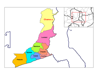
Chama is a small town in the Eastern Province of Zambia, and is headquarters of Chama District. It is one of the most remote district headquarters in the country, lying just inside the eastern edge of the upper Luangwa Rift Valley, at the foot of the highlands dividing Zambia and Malawi. It is served by only one gravel road which comes from Lundazi and the provincial capital of the Eastern Province, Chipata, 300 km to the south. A dirt track connects the town to the South Luangwa National Park 200 km south-west, running parallel to the Luangwa River. A little-used dirt track follows the Malawi border further north and crosses into Isoka District west of the Nyika Plateau. The Road Development Agency is also developing a road from Chama westwards across the Luangwa River to the town of Matumbo, where the road will end at a junction with the T2 Road, Zambia's Great North Road. It is meant to be the 2nd main road out of Chama after the Lundazi-Chipata Route and is meant to provide access for Chama Residents to the headquarters of Muchinga Province, which is Chinsali.

Lusaka is the capital and largest city of Zambia. It is one of the fastest-developing cities in southern Africa. Lusaka is in the southern part of the central plateau at an elevation of about 1,279 metres (4,196 ft). As of 2019, the city's population was about 3.3 million, while the urban population is estimated at 2.5 million in 2018. Lusaka is the centre of both commerce and government in Zambia and connects to the country's four main highways heading north, south, east, and west. English is the official language of the city administration, while Bemba and Nyanja are the commonly spoken street languages.

Kitwe District is a district of Zambia, located in Copperbelt Province. The capital is Kitwe. As of the 2022 Zambian Census, the district had a population of 661,901 people.

Ndola District is a district of Zambia, located in Copperbelt Province. The capital lies at Ndola. As of the 2022 Zambian Census, the district had a population of 624,579 people.
Choma District is a district of Zambia, located in Southern Province. The capital lies at Choma. As of the 2022 Zambian Census, the district had a population of 266,916 people. Choma has been the provincial capital of the Southern Province since 2012.

Monze District is a district of Zambia, located in Southern Province. The capital lies at Monze. As of the 2022 Zambian Census, the district had a population of 268,432 people.

Muchinga Province is one of the ten provinces of Zambia. It is located in the northeast of the country and borders with Tanzania in the north, Malawi in the east, Eastern Province in the south, Central Province in the southwest, Luapula Province in the west, and Northern Province in the northwest. The administrative center of the province is Chinsali.
Chozi is a town in the Nakonde District of Muchinga Province in Zambia.
Mwami is a town in the Eastern Province of Zambia. The town lies at the international border with Malawi, adjacent to the Malawian city of Mchinji.

