Kawambwa is a town in the Zambian province of Luapula located on thedge of the northern Zambian plateau above the Luapula valley at an altitude of 1300 m. It was chosen as an administrative district of the same name by the British colonial authorities who preferred the climate of the plateau rather than the hotter valley where most of the district's population live, and it continues as an administrative district today.

Mansa is the capital of the Luapula Province of Zambia, and headquarters of Mansa District. It takes its name from the local Chief Mansa and the small Mansa River which flows west to the Luapula River. During British rule the city was named Fort Rosebery.

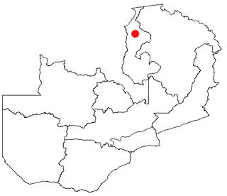
Luapula Province is one of Zambia's ten provinces located in the northern part of the country. Luapula Province is named after the Luapula River and its capital is Mansa. As per the 2010 Zambian census, the Province had a population of 991,927, which accounted for 7.57 per cent of the total Zambian population.
Kashikishi is a town on the south-eastern shore of Lake Mweru in the Luapula Province of Zambia. It lies just north of the district headquarters Nchelenge, and close enough for them to be considered twin towns; they are sometimes referred to as Nchelenge–Kashikishi.

The Ministry of Health is a ministry in Zambia. Its head offices are located in Lusaka.
Chembe is a new District pronounced by President Michael Sata in the Luapula Province of Zambia. It once had the Chembe Ferry as a means of crossing the Luapula River from DR Congo to Zambia; but now, it is the home of the Mwanawasa Bridge, named after former president Levy Mwanawasa. The Mwanawasa Bridge connects the principal Luapula highway to the Congo Pedicle road, a dirt highway maintained by Zambia through Congolese territory to link Mansa to the Copperbelt.
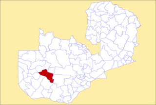
Milenge District with headquarters at Milenge, Zambia is the most southerly district in the Luapula Province and was carved out of Mansa District. As of the 2000 Zambian Census, the district had a population of 28,790 people. It is rural and undeveloped, lacking roads and infrastructure. Its southern boundary is the Luapula River which divides it from DR Congo and the district lies roughly between the Chembe Ferry to Mansa road in the west and the Kapalala Ferry to Samfya road in the east. A single dirt road runs through the central part of the district from Chembe in the west following the north-west bank of the Lwela River, passing through Milenge Boma, Milambo and Lwela Mission, eventually connecting to the provincial capital, Mansa in the north-west. Most of the population of the district lives along the shallow valley of the Lwela River. The district is gently undulating flat plateau with an elevation of about 1200 m, consisting of woodland and wooded grassland interspersed with dambos.

Chilubi District with headquarters at Chilubi is located in Northern Province, Zambia. It covers the north-east Lake Bangweulu and Bangweulu Wetlands containing several islands including Chilubi Island, and some of the mainland northeast of the lake. As of the 2000 Zambian Census, the district had a population of 66,338 people.

Samfya District is located in Luapula Province, Zambia. The headquarters is at Samfya.

Mkushi District is a district of Zambia, located in Central Province. The capital lies at Mkushi. As of the 2010 Zambian Census, the district had a population of 148,814 people. The Great North Road and Tazara railway runs through Mkushi district, connecting Kapiri Mposhi and Serenje districts. The area is largely undeveloped and home to numerous natural attractions including Lunsemfwa Wonder Gorge, Changwena Falls, and historic Fort Elwes.

Nchelenge District is a district of Zambia, located in the Luapula Province. The capital lies at Nchelenge. As of the 2000 Zambian Census, the district had a population of 111,119 people.
Mansa Airport is an airport serving Mansa, a city in the Luapula Province in Zambia. The airport is 4 kilometres (2.5 mi) north of the city.

Chitalu Chilufya is a Zambian physician and politician. He is currently a Member of the National Assembly for Mansa Central. He was Minister of Health from August 2016 to January 2021. He was fired after a scandal involving the distribution of defective leaking condoms and safety gloves.It was later discovered that the scandal was a hoax by the Dr. Christopher Kalila, MP led Parliamentary Committee on Health, Community Development and Social Services in June, 2022 as its Report for the First Session of the Thirteenth National Assembly revealed that the country had never procured expired, defective medicine and medical supplies it received were certified to be fit and safe for public consumption by the World Health Organization and Zambia Medicine Regulatory Authority.

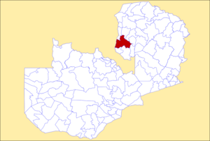
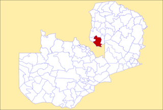
Chembe District is a district of Zambia, located in Luapula Province. The capital lies at Chembe. It was created in 2012 by splitting Mansa District.
Luampa District is a district of Zambia, located in Western Province. It was separated from Kaoma District in 2012.

Nalolo District is a district of Zambia, located in Western Province. It was separated from Senanga District in 2012.

Sikongo District is a district of Zambia, located in Western Province. It was separated from Kalabo District in 2012.
Bahati is a constituency of the National Assembly of Zambia. It covers the northern part of Mansa and a rural area to the north of the city in Mansa District of Luapula Province.
Mansa Central is a constituency of the National Assembly of Zambia. It covers the southern part of Mansa and a rural area to the south of the city in Mansa District of Luapula Province.