Northern Province is one of Zambia's ten provinces. It covers approximately one-sixth of Zambia in land area. The provincial capital is Kasama. The province is made up of 12 districts, namely Kasama District, Chilubi District, Kaputa District, Luwingu District, Mbala District, Mporokoso District, Mpulungu District, Mungwi District, Nsama District, Lupososhi District, Lunte District and Senga Hill District. Currently, only Kasama and Mbala have attained municipal council status, while the rest are still district councils. It is widely considered to be the heartland of the Bemba, one of the largest tribes in Zambia.

Central Province is one of Zambia's ten provinces. The provincial capital is Kabwe, which is the home of the Mulungushi Rock of Authority. Central Province has an area of 94,394 km (58,654 mi). It borders eight other provinces and has eleven districts. The total area of forest in the province is 9,095,566 ha, and it has a national park and three game management areas. The first mine in the region was opened up in 1905 making the then Broken Hill town the first mining town. In 1966, the town's name was reverted to its indigenous name - Kabwe meaning 'ore' or 'smelting'.

Luapula Province is one of Zambia's ten provinces located in the northern part of the country. Luapula Province is named after the Luapula River and its capital is Mansa. As per the 2022 Zambian census, the Province had a population of 1,519,478, which accounted for 7.72 per cent of the total Zambian population.

The ten provinces of Zambia are divided into a total of 116 districts as of 2018.

Chama District with the headquarters at Chama is the largest district of the Eastern Province in Zambia and includes a large wilderness in the Upper Luangwa valley just north-east of the North Luangwa National Park. It is made up of two constituencies, namely Chama North and Chama South.

Chipata District is a district of Zambia, located in Eastern Province. The capital lies at Chipata. As of the 2022 Zambian Census, the district had a population of 327,059 people.

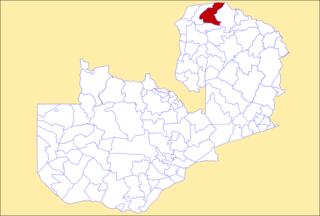
Mporokoso District is a district of Zambia, located in Northern Province. The capital lies at Mporokoso. As of the 2022 Zambian Census, the district had a population of 63,452 people.

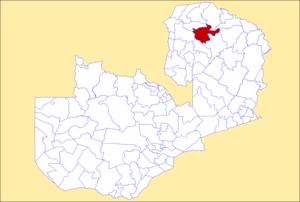
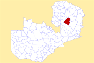
Mungwi District is a district of Zambia, located in Northern Province. The capital lies at Mungwi. As of the 2022 Zambian Census, the district had a population of 205,096 people.

Muchinga Province is one of the ten provinces of Zambia. It is located in the northeast of the country and borders with Tanzania in the north, Malawi in the east, Eastern Province in the south, Central Province in the southwest, Luapula Province in the west, and Northern Province in the northwest. The administrative center of the province is Chinsali.
Lunte is a constituency of the National Assembly of Zambia. It covers the towns of Chitoshi, Kapatu and Mukupa in Lunte District of Northern Province.

Ngabwe District is a district of Central Province, Zambia. It was separated from Kapiri Mposhi District in 2012. As of the 2022 Zambian Census, the district had a population of 42,104 people.

Shibuyunji District, also known as Sibuyunji District, is a district of Central Province, Zambia. As of the 2022 Zambian Census, the district had a population of 91,616 people.
Kanchibiya District is a district of Muchinga Province, Zambia. It was separated from Mpika District in 2017. As of the 2022 Zambian Census, the district had a population of 93,052 people.

Lavushimanda District is a district of Muchinga Province, Zambia. It was named after the Lavushi Manda National Park and separated from Mpika District in 2017. It also contains a town centre of the same name on the Great North Road. As of the 2022 Zambian Census, the district had a population of 55,755 people.
Nsama District is a district of Northern Province, Zambia. It was created in February 2012 by splitting Kaputa District. As of the 2022 Zambian Census, the district had a population of 77,651 people.

Senga District is a district of Northern Province, Zambia. It was separated from Mbala District in 2016. As of the 2022 Zambian Census, the district had a population of 126,308 people.

Mushindamo District is a district of North-Western Province, Zambia. It was created from part of Solwezi District in 2016. However, as of 2021, it is not clear where the Mushindamo Central Business District is to be located.

Pemba District is a district of Southern Province, Zambia. The district capital is Pemba. It was separated from Choma District in 2012. As of the 2022 Zambian Census, the district had a population of 101,021 people.

Lupososhi District is a district of Northern Province, Zambia. It was created in 2018 by splitting Luwingu District. As of the 2022 Zambian Census, the district had a population of 79,614 people.

Chipangali District is a district of Eastern Province, Zambia. It was made independent from Chipata District in 2018. As of the 2022 Zambian Census, the district had a population of 169,357 people.