This article is about the transport in Zambia.

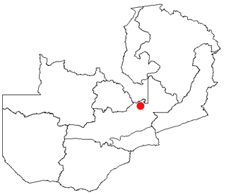
Kapiri Mposhi is a Zambian town, seat of the Kapiri Mposhi District, Central Province. Located north of Lusaka, it stands on the Great North Road and is significant for the railway connection between Zambia Railways line from Kitwe to Lusaka and Livingstone and western terminal of the Tanzania-Zambia Railway Authority from Dar es Salaam since 1976.

Serenje is a town of Serenje District, Zambia, lying just off the Great North Road and TAZARA Railway. Serenje has a railway station on the TAZARA railway. Serenje is approximately 191 km from Kapiri Mposhi on the Great North Road. Mkushi is the district west of Serenje. The Mulembo Falls lie near the town.
Mkushi is a town in the Central Province of Zambia, located on the Great North Road and the Tazara railway, northeast of Kapiri Mposhi. The Changwena Falls and Fort Elwes lie nearby. Mkushi is well known within Zambia for its commercial farms and is where Chengelo School is situated. An outbreak of fall armyworms started in Mkushi on January 6, 2022.

Central Province is one of Zambia's ten provinces. The provincial capital is Kabwe, which is the home of the Mulungushi Rock of Authority. Central Province has an area of 94,394 km (58,654 mi). It borders eight other provinces and has eleven districts. The total area of forest in the province is 9,095,566 ha, and it has a national park and three game management areas. The first mine in the region was opened up in 1905 making the then Broken Hill town the first mining town. In 1966, he town's name was reverted to its indigenous name - Kabwe meaning 'ore' or 'smelting'.
Mulungushi Rock of Authority, also known as Mulungushi Rock, is a kopje in the Central Province of Zambia associated with major political gatherings and speeches. Situated near the Mulungushi River north of Kabwe, it was first used in 1958 for a rally of the Zambian African National Congress and then in 1960 for the first conference of the newly-formed United National Independence Party. Since 1964, it has been regularly used by political parties for their annual conventions and meetings. A national symbol, the Rock of Authority is called "the birthplace of Zambian independence".
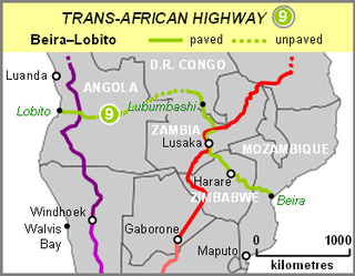
The Beira–Lobito Highway or TAH 9 is Trans-African Highway 9 in the transcontinental road network being developed by the United Nations Economic Commission for Africa (UNECA), the African Development Bank (ADB), and the African Union. The route has a length of 3,523 km (2,189 mi) crossing Angola, the most southerly part of the Democratic Republic of the Congo, Zambia, Zimbabwe, and central Mozambique.

Kapiri Mposhi is a constituency of the National Assembly of Zambia. It covers the town of Kapiri Mposhi in Central Province.
Chitemene, from the ciBemba word meaning “place where branches have been cut for a garden”, is a system of slash and burn agriculture practiced throughout northern Zambia. It involves coppicing or pollarding of standing trees in a primary or secondary growth Miombo woodland, stacking of the cut biomass, and eventual burning of the cut biomass in order to create a thicker layer of ash than would be possible with in situ burning. Crops such as maize, finger millet, sorghum, or cassava are then planted in the burned area.

Mkushi District is a district of Zambia, located in Central Province. The capital lies at Mkushi. As of the 2010 Zambian Census, the district had a population of 148,814 people. The Great North Road runs through Mkushi district, connecting Kapiri Mposhi and Serenje districts. The area is largely undeveloped and home to numerous natural attractions including Lunsemfwa Wonder Gorge, Changwena Falls, and historic Fort Elwes.
The diocese of Kabwe is a diocese of the Roman Catholic Church located in Kabwe, Zambia.
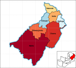
Muchinga Province is one of the ten provinces of Zambia. It is located in the northeast of the country and borders with Tanzania in the north, Malawi in the east, Eastern Province in the south, Central Province in the southwest, Luapula Province in the west, and Northern Province in the northwest. The administrative center of the province is Chinsali.
Chipepo Peter Friday Malwa is a Zambian politician. He served as Member of the National Assembly for Kapiri Mposhi from 2006 until 2011.
John Mwaimba is a Zambian politician. He served as Member of the National Assembly for Kapiri Mposhi from 2002 until 2006.
Macdonald Nkabika is a Zambian businessman and former politician. He served as Member of the National Assembly for Kapiri Mposhi from 1996 until 2001.
Gabriel Kanyenda Maka was a Zambian politician and diplomat. He served as Member of the National Assembly for Kapiri Mposhi from 1991 until 1996 and was the Zambian Ambassador to Egypt between 2003 and 2004.
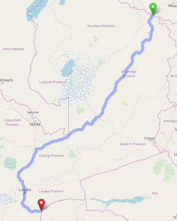
The T2 is a trunk road in Zambia. The road runs from the Tunduma border with Tanzania via Mpika, Kabwe and Lusaka to the Chirundu border with Zimbabwe. The road is the longest route of the country, as it is approximately 1,155 kilometres (718 mi). The entire route is a toll road.

The T3 is a Trunk Road in Zambia. The road runs from Kapiri Mposhi via Ndola, Kitwe and Chingola to Kasumbalesa on the border with DR Congo. The entire route is a toll road.
Chisamba District is a district of Central Province, Zambia, it covers a total surface area of 5, 526 sq.km and is known for its agricultural activities with over 32,000 small scale farming families and 256 commercial farmers, the majority of whom are white Zambians. It shares borders with Lusaka, Chongwe, Chibombo, Kabwe, Kapiri Mposhi and Luano Districts. The District has a total population of 103,983 of which 51,955 are females and 52,028 are males.
Ngabwe District is a district of Central Province, Zambia. It was separated from Kapiri Mposhi District in 2012.
