D'Aguilar National Park

Last updated

D'Aguilar National Park
Queensland
Westridge Outlook view, D'Aguilar National Park.jpg
Westridge Outlook, D'Aguilar National Park
Australia Queensland location map.svg
Red pog.svg
D'Aguilar National Park
Coordinates 27°18′32″S152°46′40″E / 27.30889°S 152.77778°E / -27.30889; 152.77778
Established1938
Area20.50 km2 (7.9 sq mi)
Managing authorities Queensland Parks and Wildlife Service
Website D'Aguilar National Park
See also Protected areas of Queensland
Water hole in D'Aguilar National Park D'Aguilar National Park reflections.jpg
Water hole in D'Aguilar National Park

D'Aguilar National Park is a national park in Queensland, Australia. It contains the D'Aguilar Range and is located along the northwest of the Brisbane metropolitan area. The park is traversed by the winding scenic Mount Nebo Road and Mount Glorious Road.

Contents

The park contains eucalyptus woodlands, sheltered pockets of sub-tropical rainforest, a number of crevasses and views of Moreton Bay and the Glass House Mountains. [1] The Walkabout Creek Visitor Centre is located at the edge of the park. There are two formal, vehicle accessible camping areas in the Mount Mee section and eight remote bush camping sites (accessible only by walking) in the southern D'Aguilar (formerly Brisbane Forest Park) section. [2] Popular lookouts include Jolly's Lookout, Westridge Outlook, Camp Mountain Lookout and Wivenhoe Lookout, overlooking Lake Wivenhoe. The villages of Mount Nebo and Mount Glorious are located on Mount Nebo Road on the edges of the national park and are popular stops for tourists driving through the park.

The southern part of the park was formerly known as Brisbane Forest Park, while the northern part of the park is at Mount Mee.

Flora

Woodlands and dry eucalypt forests predominate on the drier, shallower soils of the park's foothills. Spotted Gum (Corymbia variegata) and Narrow-leaved Ironbark are two of the main species. There are also small areas of heath and ridges dominated by grass trees (Xanthorrhoea spp). Remnant pockets of lowland rainforest occur in the valleys along some of the watercourses. [3]

At higher altitudes the forests become more complex due to the increased rainfall and generally deeper soils. These mid-altitude forests are dominated by Grey Gum, Pink Bloodwood and Brush Box. Occasional rainforest species are also present and there is a thick understorey of ferns, vines and shrubs. [3]

Mount Glorious Road, 2016 Following mountains ridge Mount Glorious Road through D'Aguilar National Park, Queensland 02.jpeg
Mount Glorious Road, 2016
View from Greenes Falls, Mt Glorious Greenes Falls.jpg
View from Greenes Falls, Mt Glorious

Moist sub-tropical rainforest grows on the highest parts of the range where the rainfall is two-thirds greater than in the foothills, particularly on the rich basaltic soils north of Mt Glorious. Huge strangler figs (Ficus watkinsiana) can be seen emerging through the canopy. [3]

Fauna

More than 240 species of birds have been recorded in the park, including the noisy pitta (Pitta versicolor), southern logrunner (Orthonyx temminckii), paradise riflebird (Ptiloris paradiseus), regent bowerbird (Sericulus chrysocephalus), satin bowerbird (Ptilonorhynchus violaceus), brush-turkey (Alectura lathami), laughing kookaburra (Dacelo novaeguineae), pied currawong (Strepera graculina), red goshawk (Erythrotriorchis radiatus), marbled frogmouth (Podargus ocellatus), bush-hen (Amaurornis olivacea), black-breasted button quail (Turnix melanogaster), white-bellied sea eagle (Haliaeetus leucogaster), comb-crested jacana (Irediparra gallinacea) and cotton pygmy goose (Nettapus coromandelianus). [3]

66 mammal species have been recorded in the park, including the echidna (Tachyglossus aculeatus), platypus (Ornithorhynchus anatinus), red-necked pademelon (Thylogale thetis), short-eared possum (Trichosurus caninus), common ringtail possum (Pseudocheirus peregrinus), northern brown bandicoot (Isoodon macrourus), long-nosed bandicoot (Perameles nasuta), Long-nosed potoroo (Potorous tridactylus), insectivorous bats, fruit bats ("flying foxes") (Pteropus spp.), several species of gliding possums and small numbers of koalas (Phascolarctos cinereus) and kangaroos. [3]

There are a variety of reptile species in the park. This includes the tree goanna/lace monitor (Varanus varius), which is a large monitor lizard and the land mullet (Egernia major), which is a large, shiny black skink. 26 species of frogs have been recorded in the park, including the great barred frog (Mixophyes fasciolatus). The most common amphibian in the park is an introduced pest, the cane toad (Rhinella marina). [3]

See also

Related Research Articles

<span class="mw-page-title-main">New England National Park</span> Protected area in New South Wales, Australia

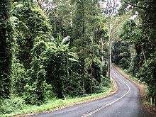
The New England National Park is a protected national park located on the Northern Tablelands in the New England region of New South Wales, Australia. The 67,303-hectare (166,310-acre) park was created in May 1935 and is situated approximately 560 kilometres (350 mi) north of Sydney, and 10 kilometres (6.2 mi) south of Waterfall Way, just 85 kilometres (53 mi) east of Armidale and 65 kilometres (40 mi) west of Coffs Harbour. The closest village to New England National Park is Ebor, located 20 kilometres (12 mi) away.

<span class="mw-page-title-main">Bunya Mountains National Park</span> Protected area in Queensland, Australia

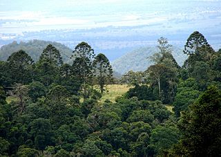
Bunya Mountains is a national park in the South Burnett Region, Queensland, Australia.

<span class="mw-page-title-main">Burleigh Head National Park</span> Protected area in Queensland, Australia

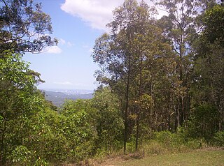
Burleigh Head is a small national park at Burleigh Heads in the City of Gold Coast in South East Queensland, Australia.

<span class="mw-page-title-main">Noosa National Park</span> Protected area in Queensland, Australia

Noosa National Park is a national park in Queensland, Australia, 121 km north of Brisbane. It is situated near Noosa Heads between the Pacific Ocean and the Sunshine Coasts's northern area of urban development and extends southwards, past Lake Weyba to Coolum.

<span class="mw-page-title-main">Springbrook National Park</span> Protected area in Queensland, Australia

The Springbrook National Park is a protected national park that is located in the Gold Coast hinterland of Queensland, Australia. The 6,197-hectare (15,310-acre) park is situated on the McPherson Range, near Springbrook, approximately 100 kilometres (62 mi) south of Brisbane. The park is part of the Shield Volcano Group of the UNESCO World Heritage–listed Gondwana Rainforests of Australia.

<span class="mw-page-title-main">Tamborine National Park</span> Protected area in Queensland, Australia

Tamborine is a national park in the Gold Coast hinterland and is a part of the Scenic Rim Regional Council of South East Queensland, Australia, 45 km (28 mi) south of Brisbane.

<span class="mw-page-title-main">D'Aguilar Range</span> Mountain range in Australia

The D'Aguilar Range is a mountain range near Brisbane, Queensland, Australia. The town of Dayboro is situated on the lower foothills midway along the range and the Sunshine Coast Hinterland town of Mooloolah lies at the northernmost point of the range. Many residential areas line its eastern slopes including the town of Samford and the suburb of Ferny Hills. In the west, numerous ridges and gullies are heavily forested and designated as state forest or national park.

<span class="mw-page-title-main">Mount Glorious</span> Suburb of City of Moreton Bay, Queensland, Australia

Mount Glorious is a rural locality in the City of Moreton Bay, Queensland, Australia. In the 2016 census, Mount Glorious had a population of 296 people.

<span class="mw-page-title-main">Brisbane Forest Park</span> Protected area in Queensland, Australia

Brisbane Forest Park, is located on parts of the D'Aguilar Range. The large nature reserve lies on the western boundary of City of Brisbane into the City of Moreton Bay, Queensland, Australia, in Enoggera Reservoir, adjacent to The Gap and between the Mount Coot-tha Reserve on the Taylor Range and higher peaks to the north. Brisbane Forest Park supports plants and animals and is essential to their survival. The main entrance is located in the suburb of The Gap although there are a number of other access points.

<span class="mw-page-title-main">Camp Mountain, Queensland</span> Suburb of City of Moreton Bay, Queensland, Australia

Camp Mountain is a rural locality in the City of Moreton Bay, Queensland, Australia. In the 2016 census, Camp Mountain had a population of 1,416 people.

<span class="mw-page-title-main">Mount Mee, Queensland</span> Town in Queensland, Australia

Mount Mee is a rural town and locality in the City of Moreton Bay, Queensland, Australia. In the 2021 census, Mount Mee had a population of 519 people.

Burpengary Creek is a tidal creek in the City of Moreton Bay, Queensland, Australia. It has a total catchment area of 7,960 hectares. It is about 40 kilometres north of Brisbane,

<span class="mw-page-title-main">Springbrook, Queensland</span> Town in Queensland, Australia

Springbrook is a rural town and locality in the City of Gold Coast, Queensland, Australia. In the 2016 census, the locality of Springbrook had a population of 659 people.

<span class="mw-page-title-main">Boorganna Nature Reserve</span> Protected area in New South Wales, Australia

The Boorganna Nature Reserve is a protected nature reserve located northwest of Taree on the Comboyne Plateau in New South Wales, Australia. The 396-hectare (980-acre) reserve, managed by the NSW National Parks & Wildlife Service, was gazetted in 1904 and is the second oldest nature reserve in the state. The reserve features various forest types, including stands of sub tropical rainforest of which the large rosewood, yellow carabeen and small leaf fig are particularly noteworthy. The reserve is a remnant of the former extensive rainforest on the Comboyne Plateau. The plateau was cleared between 1900 and 1925. Australian red cedar was logged in the area in the nineteenth century. Originally proposed to be part of the world heritage rainforest group. The exploration, knowledge, uses and history of this area by Indigenous Australians is not well known in the present day. Boorganna Nature Reserve was proposed, but rejected for inclusion on the UNESCO World Heritage, due to being geographically isolated from other rainforests in the group.

<span class="mw-page-title-main">Minyon Falls</span> Waterfall in New South Wales, Australia

The Minyon Falls is a plunge waterfall on Repentance Creek in the Northern Rivers region of New South Wales, Australia. The waterfall descends more than 100 metres (330 ft) over the huge rhyolite cliffs which were once part of the Tweed Volcano. The water flow eroded the rocks to create the waterfall.

<span class="mw-page-title-main">Brisbane Valley Rail Trail</span> Rail trail in Queensland, Australia

The Brisbane Valley Rail Trail (BVRT) is a 161-kilometre (100 mi) recreation trail from Wulkuraka to Yarraman in Queensland, Australia. The trail follows the old Brisbane Valley railway line and is open to walkers, touring cyclists and horse riders. The trail details the history and landscape of the Brisbane Valley. It is the longest rail trail in Queensland.

<span class="mw-page-title-main">Jollys Lookout, Queensland</span> Suburb of City of Moreton Bay, Queensland, Australia

Jollys Lookout is a rural locality in the City of Moreton Bay, Queensland, Australia. In the 2016 census, Jollys Lookout had a population of 76 people.

<span class="mw-page-title-main">Dundas, Queensland</span> Suburb of Somerset Region, Queensland, Australia

Dundas is a rural locality in the Somerset Region, Queensland, Australia. In the 2016 census Dundas had a population of 77 people.

<span class="mw-page-title-main">Geography of Brisbane</span> Geography of the city of Brisbane in Queensland, Australia

The geography of Brisbane is characterised by its coastal location in the south eastern corner of the Queensland state of Australia. It is located halfway up the Australian east coast with longitudinal and latitudinal coordinates of 27.5° south and 153° east. The city resides within the Moreton Bay Floodplain, stretching from Caboolture to the north, Beenleigh to the south and as far as Ipswich to the west whilst being bordered by the Pacific Ocean to the east.

References

  1. D'Aguilar National Park. Retrieved 18 November 2012.
  2. Camping information. Retrieved 18 November 2012.
  3. 1 2 3 4 5 6 Wild places of Greater Brisbane - Stephen Poole et al. Queensland Museum. 1996. ISBN   0 7242 7110 4